Difference between revisions of "2012-06-30 -38 145"
imported>Talex (View of the river from the hash) |
m (More specific location) |
||
| (14 intermediate revisions by 5 users not shown) | |||
| Line 1: | Line 1: | ||
| − | |||
<!-- If you did not specify these parameters in the template, please substitute appropriate values for IMAGE, LAT, LON, and DATE (YYYY-MM-DD format) | <!-- If you did not specify these parameters in the template, please substitute appropriate values for IMAGE, LAT, LON, and DATE (YYYY-MM-DD format) | ||
| Line 15: | Line 14: | ||
}} | }} | ||
| − | + | ||
__NOTOC__ | __NOTOC__ | ||
== Location == | == Location == | ||
| − | + | On the bank of the Lang Lang River, next to farm land. | |
== Participants == | == Participants == | ||
| − | + | * [[User:Talex|Talex]], | |
| − | + | * Aimee and | |
| + | * [[User:Lachie|Lachie]] | ||
== Plans == | == Plans == | ||
| Line 28: | Line 28: | ||
== Expedition == | == Expedition == | ||
| − | + | Lachie, Aimee, MJ and [[User:Talex|Talex]] were in a car off to a party at [[User:Felix Dance|Felix Dance]]'s place, conveniently the route was rather close to the geohash. | |
| + | |||
| + | As we approached the threatening clouds began to rain and our prospects of a dry hash diminished. Lachie and I | ||
| + | decided to do the hash with no pants (to keep them dry for party time). Aimee was more sensible and had spare clothes. | ||
| + | MJ was lame and stayed in the car. | ||
| + | |||
| + | We walked along the river bank, keeping to public land, bashing through some spiky scrub and eventually making it to the hash. After uploading a photo and message, we returned to the car. | ||
| + | |||
| + | Now at Felix's with 4 kegs. Yay! | ||
*Geohash success -- [[User:Talex|Talex]] [http://www.openstreetmap.org/?lat=-38.24212322&lon=145.66152911&zoom=16&layers=B000FTF @-38.2421,145.6615] 02:46, 30 June 2012 (EDT) | *Geohash success -- [[User:Talex|Talex]] [http://www.openstreetmap.org/?lat=-38.24212322&lon=145.66152911&zoom=16&layers=B000FTF @-38.2421,145.6615] 02:46, 30 June 2012 (EDT) | ||
| − | |||
| − | |||
== Photos == | == Photos == | ||
| − | + | ||
| − | + | ||
| − | |||
<gallery perrow="5"> | <gallery perrow="5"> | ||
| − | |||
Image:2012-06-30_-38_145_17-14-22-560.jpg | | Image:2012-06-30_-38_145_17-14-22-560.jpg | | ||
| − | + | Image:2012-06-30_-38_145_17-15-23-207.jpg | tAlex, aimee and lachie at the hash point. | |
| − | Image:2012-06-30_-38_145_17-15-23-207.jpg | | ||
| − | |||
Image:2012-06-30_-38_145_17-17-14-417.jpg | View of the river from the hash | Image:2012-06-30_-38_145_17-17-14-417.jpg | View of the river from the hash | ||
| + | Image:2012-06-30_-38_145_17-17-52-974.jpg | Walking out to the hash | ||
</gallery> | </gallery> | ||
== Achievements == | == Achievements == | ||
{{#vardefine:ribbonwidth|800px}} | {{#vardefine:ribbonwidth|800px}} | ||
| − | |||
| − | + | {{land geohash | |
| − | + | | latitude = -38 | |
| − | [[ | + | | longitude = 145 |
| + | | date = 2012-06-30 | ||
| + | | name = [[User:Lachie|Lachlan Gordon]] | ||
| + | }} | ||
| − | + | [[Category:Expeditions]] | |
| − | |||
| − | [[Category: | ||
| − | |||
| − | |||
| − | |||
| − | |||
[[Category:Expeditions with photos]] | [[Category:Expeditions with photos]] | ||
| − | |||
| − | |||
| − | |||
| − | |||
| − | |||
[[Category:Coordinates reached]] | [[Category:Coordinates reached]] | ||
| − | + | {{location|AU|VIC|CA}} | |
| − | |||
| − | |||
| − | |||
| − | |||
| − | |||
| − | |||
| − | |||
| − | |||
| − | |||
Latest revision as of 12:18, 1 August 2020
| Sat 30 Jun 2012 in -38,145: -38.2420946, 145.6615016 geohashing.info google osm bing/os kml crox |
Location
On the bank of the Lang Lang River, next to farm land.
Participants
Plans
Expedition
Lachie, Aimee, MJ and Talex were in a car off to a party at Felix Dance's place, conveniently the route was rather close to the geohash.
As we approached the threatening clouds began to rain and our prospects of a dry hash diminished. Lachie and I decided to do the hash with no pants (to keep them dry for party time). Aimee was more sensible and had spare clothes. MJ was lame and stayed in the car.
We walked along the river bank, keeping to public land, bashing through some spiky scrub and eventually making it to the hash. After uploading a photo and message, we returned to the car.
Now at Felix's with 4 kegs. Yay!
- Geohash success -- Talex @-38.2421,145.6615 02:46, 30 June 2012 (EDT)
Photos

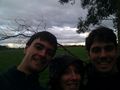
tAlex, aimee and lachie at the hash point.
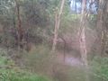
View of the river from the hash
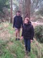
Walking out to the hash


Achievements
Lachlan Gordon earned the Land geohash achievement
|