Difference between revisions of "2013-10-28 -34 138"
imported>DODO (→Enough about Metadata Already) |
m (More specific location) |
||
| (One intermediate revision by one other user not shown) | |||
| Line 100: | Line 100: | ||
(Don't forget to delete this final close comment marker) --> | (Don't forget to delete this final close comment marker) --> | ||
| + | {{location|AU|SA|BU}} | ||
Latest revision as of 12:40, 1 August 2020
| Mon 28 Oct 2013 in -34,138: -34.9409902, 138.6599519 geohashing.info google osm bing/os kml crox |
Location
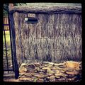
559 Glynburn Road, Hazelwood Park. Just a suburban house, really. The actual point was in the back yard somewhere, and I don't know the people who live there, so I didn't go in.
Participants
Just Brendan. Nobody else. :-(
Plans
I was thinking about geohashing last night, and this morning when I saw the location I thought - cool. A location that's close enough to get to, on a day when I don't have to go to work, and I have a half hour when I don't have any other stuff I need to get done.
Expedition
Just drove ... dropped the wifey off at a physio appointment, and had 30 minutes to kill.
Tracklog
I don't actually have a tracklog (unless you count the metadata in the iPhone / Instragram photo), nor proof of date (again unless you count the photo metadata).
Pity, I might have gotten the Land geohash achievement... if I'd had my StupidGrinTM in the photo...
Photos
Achievements
Well, I nearly got the Land geohash achievement, but the photo doesn't have the GrinTM. Nor does it have proof of date or location, unless you count the photo metadata.
Enough about Metadata Already
...so, does anyone actually know whether photo metadata is considered Good Enough EvidenceTM for achievements?
