Difference between revisions of "2015-11-10 -38 144"
From Geohashing
imported>Benkaiser |
m (More specific location) |
||
| (One intermediate revision by one other user not shown) | |||
| Line 35: | Line 35: | ||
[[Category:Expeditions with photos]] | [[Category:Expeditions with photos]] | ||
[[Category:Coordinates reached]] | [[Category:Coordinates reached]] | ||
| + | {{location|AU|VIC|GG}} | ||
Latest revision as of 12:45, 1 August 2020
| Tue 10 Nov 2015 in -38,144: -38.0818643, 144.3245593 geohashing.info google osm bing/os kml crox |
Contents
[hide]Location
In a field near Lovely Banks
Participants
Samuel Kaiser
Expedition
Drove to the road near the location with Sam. We didn't have to jump any fences, it was an open field so we walked straight to the geohash, took some photos and left.
Photos
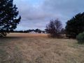
View from the hashpoint
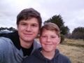
Selfie of Sam and I
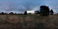
Photosphere of the road at the hashpoint
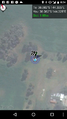
Screenshot at geohash


