imported>Felix Dance |
|
| (5 intermediate revisions by 3 users not shown) |
| Line 27: |
Line 27: |
| | Not today though! Seeing this hash near the Altona wetlands I jumped on my bike, did some things in the city, then came back the other way via Seddon and Williamstown to get to Altona and hence the hash, stopping only for some potato cakes at a fish and chips place. | | Not today though! Seeing this hash near the Altona wetlands I jumped on my bike, did some things in the city, then came back the other way via Seddon and Williamstown to get to Altona and hence the hash, stopping only for some potato cakes at a fish and chips place. |
| | | | |
| − | When I got to the locality, my ride through the coastal park quickly turned to mud, so I back-tracked and found another way, this one involving ditching my bike and proceeding on foot. Soon I came to a creek, which I washed across sans shoes and socks (still drenched my jeans though). But the path got easier and soon I was walking along a narrow spit of land with metres to go. | + | When I got to the locality, my ride through the Cheetham Wetlands, which is where I was, quickly turned to mud, so I back-tracked and found another way, this one involving ditching my bike and proceeding on foot. Soon I came to a creek, which I washed across sans shoes and socks (still drenched my jeans though). But the path got easier and soon I was walking along a narrow spit of land with metres to go. |
| | | | |
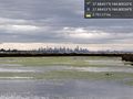
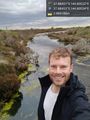
| | It started raining, but I already had it. The hash was an arm's length out into a pondage, so I captured it, and my surroundings, including a great view of the city skyline and oncoming storm. I am making my way back to the bike as we speak. | | It started raining, but I already had it. The hash was an arm's length out into a pondage, so I captured it, and my surroundings, including a great view of the city skyline and oncoming storm. I am making my way back to the bike as we speak. |
| | | | |
| − | [Shared route | + | [https://goo.gl/maps/xh1zYvY2cAG2 Here] is the route I took. |
| − | From Home to Westona via Macaulay Rd.
| |
| − | | |
| − | 2 hr 9 min (35 km)
| |
| − | | |
| − | | |
| − | 1. Head north-east on Ormond St towards Bellair St
| |
| − | 2. Turn left onto Bellair St
| |
| − | 3. Turn right onto Macaulay Rd
| |
| − | 4. Continue onto Dryburgh St
| |
| − | 5. Turn left onto Queensberry St
| |
| − | 6. Turn right onto Abbotsford St
| |
| − | 7. Turn left onto Elm St
| |
| − | 8. Turn right onto Curzon St/State Route 60
| |
| − | 9. Turn left onto King St/State Route 60
| |
| − | 10. Turn left towards William St
| |
| − | 11. Turn right onto William St
| |
| − | 12. Turn left onto Flinders St/State Route 30
| |
| − | 13. Turn right onto St Kilda Rd/Swanston St
| |
| − | 14. Arrive at location: Flinders Street Station
| |
| − | 15. Head north on St Kilda Rd/Swanston St towards Flinders St/State Route 30
| |
| − | 16. Turn right onto Flinders St/State Route 30
| |
| − | 17. Turn left onto Spring St
| |
| − | 18. Slight left to stay on Spring St
| |
| − | 19. Arrive at location: 1 Lonsdale St
| |
| − | 20. Head north on Spring St towards Little Lonsdale St
| |
| − | 21. Turn left onto Victoria St/Victoria Parade/State Route 32
| |
| − | 22. Turn left onto La Trobe St
| |
| − | 23. Turn right onto Harbour Esplanade
| |
| − | 24. Turn left
| |
| − | 25. Slight right
| |
| − | 26. Keep left
| |
| − | 27. Continue straight
| |
| − | 28. Turn right onto the ramp to Footscray Rd/State Route 32
| |
| − | 29. Merge onto Footscray Rd/State Route 32
| |
| − | 30. Turn left onto Hyde St
| |
| − | 31. Continue onto Douglas Parade/State Route 35
| |
| − | 32. Turn left onto North Rd
| |
| − | 33. Turn right onto The Strand
| |
| − | 34. Enter the roundabout
| |
| − | 35. Arrive at location: 270 Nelson Pl
| |
| − | 36. Head south towards Nelson Pl
| |
| − | 37. Exit the roundabout onto Ferguson St
| |
| − | 38. At the roundabout, continue straight onto Ferguson St/State Route 35
| |
| − | 39. Exit the roundabout onto Ferguson St/State Route 35
| |
| − | 40. At the roundabout, continue straight to stay on Ferguson St/State Route 35
| |
| − | 41. Exit the roundabout onto Ferguson St/State Route 35
| |
| − | 42. At the roundabout, continue straight onto Kororoit Creek Rd/State Route 35
| |
| − | 43. Exit the roundabout onto Kororoit Creek Rd/State Route 35
| |
| − | 44. At the roundabout, continue straight to stay on Kororoit Creek Rd/State Route 35
| |
| − | 45. Exit the roundabout onto Kororoit Creek Rd/State Route 35
| |
| − | 46. At the roundabout, continue straight to stay on Kororoit Creek Rd/State Route 35
| |
| − | 47. Exit the roundabout onto Kororoit Creek Rd/State Route 35
| |
| − | 48. Turn left onto Maddox Rd
| |
| − | 49. Turn right onto Bay Trail W
| |
| − | 50. Turn right to stay on Bay Trail W
| |
| − | 51. Turn right to stay on Bay Trail W
| |
| − | 52. Slight left to stay on Bay Trail W
| |
| − | 53. Turn left onto Esplanade
| |
| − | 54. Slight right onto Bay Trail W
| |
| − | 55. Turn left to stay on Bay Trail W
| |
| − | 56. Arrive at location: -37.8845140, 144.8053190
| |
| − | 57. Head north-east on Bay Trail W
| |
| − | 58. Turn right to stay on Bay Trail W
| |
| − | 59. Slight left onto Esplanade
| |
| − | 60. Turn left onto Maidstone St
| |
| − | 61. At the roundabout, continue straight onto Maidstone St/State Route 39
| |
| − | 62. Exit the roundabout onto Maidstone St/State Route 39
| |
| − | 63. At the roundabout, continue straight to stay on Maidstone St/State Route 39
| |
| − | 64. Exit the roundabout onto Maidstone St/State Route 39
| |
| − | 65. Turn right onto Harrington St
| |
| − | 66. Arrive at location: Westona
| |
| − | | |
| − | To see this route visit https://goo.gl/maps/QQoUkDNQygN2 Here] is the route I took.
| |
| | | | |
| | == Photos == | | == Photos == |
| Line 126: |
Line 53: |
| | | | |
| | == Achievements == | | == Achievements == |
| − | {{#vardefine:ribbonwidth|800px}} | + | {{bicycle geohash |
| − | <!-- Add any achievement ribbons you earned below, or remove this section -->
| |
| | | | |
| − | <!-- =============== USEFUL CATEGORIES FOLLOW ================
| + | | latitude = -37 |
| − | Delete the next line ONLY if you have chosen the appropriate categories below. If you are unsure, don't worry. People will read your report and help you with the classification. -->
| + | | longitude = 144 |
| − | [[Category:New report]] | + | | date = 2018-08-31 |
| | + | | name = [[User:Felix Dance|Felix Dance]] |
| | + | | distance = 35 kms |
| | + | | bothways = false |
| | + | | image = 2018-08-31 -37 144 Felix Dance 1535688617984.jpg |
| | + | }} |
| | | | |
| − | <!-- ==REQUEST FOR TWITTER BOT== Please leave either the New report or the Expedition planning category in as long as you work on it. This helps the twitter bot a lot with announcing the right outcome at the right moment. -->
| |
| − |
| |
| − | <!-- Potential categories. Please include all the ones appropriate to your expedition -->
| |
| − | <!-- If this is a planning page:
| |
| − | [[Category:Expedition planning]]
| |
| − | -->
| |
| − |
| |
| − | <!-- If all those plans are never acted upon, change [[Category:Expedition planning]] to [[Category:Not reached - Did not attempt]]. -->
| |
| − |
| |
| − | <!-- An actual expedition:
| |
| | [[Category:Expeditions]] | | [[Category:Expeditions]] |
| − | -- and one or more of --
| |
| | [[Category:Expeditions with photos]] | | [[Category:Expeditions with photos]] |
| − | [[Category:Expeditions with videos]]
| |
| | [[Category:Expedition without GPS]] | | [[Category:Expedition without GPS]] |
| − | -->
| |
| − |
| |
| − | <!-- if you reached your coords:
| |
| | [[Category:Coordinates reached]] | | [[Category:Coordinates reached]] |
| − | | + | {{location|AU|VIC|HB}} |
| − | | |
| − | --><!-- or if you failed :(
| |
| − | [[Category:Coordinates not reached]]
| |
| − | -- and a reason --
| |
| − | When there is a natural obstacle between you and the target:
| |
| − | [[Category:Not reached - Mother Nature]]
| |
| − |
| |
| − | When there is a man-made obstacle between you and the target:
| |
| − | [[Category:Not reached - No public access]]
| |
| − | | |
| − | When you failed get your GPS, car, bike or such to work:
| |
| − | [[Category:Not reached - Technology]]
| |
| − |
| |
| − | When you went to an alternate location instead of the actual geohash:
| |
| − | [[Category:Not reached - Attended alternate location]]
| |
| − | | |
| − | (Don't forget to delete this final close comment marker) -->
| |
Location
In marshy swampland on the Altona coast.
Participants
Expedition
I've been looking out for geohashes each day as I bum my way around at home not being gainfully employed. Most have been sort-of accessible but not very interesting, so I'd been feeling guilty about not going for any.
Not today though! Seeing this hash near the Altona wetlands I jumped on my bike, did some things in the city, then came back the other way via Seddon and Williamstown to get to Altona and hence the hash, stopping only for some potato cakes at a fish and chips place.
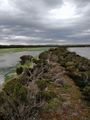
When I got to the locality, my ride through the Cheetham Wetlands, which is where I was, quickly turned to mud, so I back-tracked and found another way, this one involving ditching my bike and proceeding on foot. Soon I came to a creek, which I washed across sans shoes and socks (still drenched my jeans though). But the path got easier and soon I was walking along a narrow spit of land with metres to go.
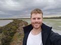
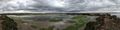
It started raining, but I already had it. The hash was an arm's length out into a pondage, so I captured it, and my surroundings, including a great view of the city skyline and oncoming storm. I am making my way back to the bike as we speak.
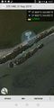
Here is the route I took.
Photos
Achievements