Difference between revisions of "2018-09-26 -37 144"
imported>Felix Dance ([live picture]Squinty me at hash) |
m (More specific location) |
||
| (11 intermediate revisions by 3 users not shown) | |||
| Line 1: | Line 1: | ||
| − | |||
| − | |||
| − | |||
| − | |||
| − | |||
| − | |||
| − | |||
| − | |||
| − | |||
| − | |||
{{meetup graticule | {{meetup graticule | ||
| lat=-37 | | lat=-37 | ||
| Line 14: | Line 4: | ||
| date=2018-09-26 | | date=2018-09-26 | ||
}} | }} | ||
| − | |||
| − | |||
| − | |||
== Location == | == Location == | ||
| − | + | On pigface in the Altona wetlands. | |
== Participants == | == Participants == | ||
| − | + | *[[User:Felix Dance|Felix Dance]] | |
| − | + | ||
| + | == Expedition == | ||
| + | Lovely hash! Got up, saw the accessibility of this one, got on my bike and headed off towards hash, following my usual south-western bike path route. | ||
| − | + | Arriving in Spotswood, I decided to vary it up a bit, discovering new bike paths in the Seddon region by heading inland somewhat. Obviously, these bike paths had already been discovered by those who came before, but they were new to me. | |
| − | |||
| − | + | Pretty quickly I was 50m from the hash. I stepped off my bike and gingerly walked over the red and green (?) coastal pigface to arrive at the hash location. A passing cyclist eyed me curiously. | |
| − | + | ||
| + | I took some ace photos of my surrounds and headed home back along the coast, stopping briefly to see the 1pm timeball fall and to have a snack lunch at a park in Williamstown, feeling impressed with the sunny weather and my ability to be submerged within it. | ||
| + | [https://goo.gl/maps/zQUiW2PJBbM2 Here] is the route of my trip. | ||
*Geohash success! -- [[User:Felix Dance|Felix Dance]] ([[User talk:Felix Dance|talk]]) [http://www.openstreetmap.org/?lat=-37.85810440&lon=144.85250910&zoom=16&layers=B000FTF @-37.8581,144.8525] 12:11, 26 September 2018 (GMT+10:00) | *Geohash success! -- [[User:Felix Dance|Felix Dance]] ([[User talk:Felix Dance|talk]]) [http://www.openstreetmap.org/?lat=-37.85810440&lon=144.85250910&zoom=16&layers=B000FTF @-37.8581,144.8525] 12:11, 26 September 2018 (GMT+10:00) | ||
| − | |||
| − | |||
== Photos == | == Photos == | ||
| − | |||
| − | |||
| − | |||
<gallery perrow="5"> | <gallery perrow="5"> | ||
| Line 47: | Line 32: | ||
Image:2018-09-26_-37_144_Felix Dance_1537927991924.jpg|Squinty me at hash | Image:2018-09-26_-37_144_Felix Dance_1537927991924.jpg|Squinty me at hash | ||
| − | |||
| − | + | Image:2018-09-26_-37_144_Felix Dance_1537928027925.jpg|My bike waiting for me | |
| − | |||
| − | |||
| − | + | Image:2018-09-26_-37_144_Felix Dance_1537928060170.jpg|City view | |
| − | |||
| − | |||
| − | + | Image:2018-09-26_-37_144_Felix Dance_1537928093832.jpg|Cool container ship going under the Westgate Bridge on the way to the hash | |
| − | + | Image:2018-09-26_-37_144_Felix Dance_1537929858407.jpg|Floating boat [http://www.openstreetmap.org/?lat=-37.86891660&lon=144.89593030&zoom=16&layers=B000FTF @-37.8689,144.8959] | |
| − | |||
| − | |||
| − | -- | ||
| − | + | Image:2018-09-26_-37_144_Felix Dance_1537934405134.jpg|Hashorama! | |
| + | </gallery> | ||
| − | + | More, higher resolution photos [https://photos.app.goo.gl/uuvQLRc9WWiBpmFY7 here]. | |
| − | |||
| − | |||
| − | |||
| − | |||
| − | |||
| − | |||
| − | |||
| − | |||
| − | |||
| + | == Achievements == | ||
| + | {{bicycle geohash | ||
| − | -- | + | | latitude = -37 |
| − | [[ | + | | longitude = 144 |
| − | + | | date = 2018-09-26 | |
| − | + | | name = [[User:Felix Dance|Felix Dance]] | |
| − | + | | distance = 32 kms | |
| − | + | | bothways = true | |
| − | + | | image = 2018-09-26_-37_144_Felix Dance_1537927940336.jpg | |
| − | |||
| − | + | }} | |
| − | |||
| − | |||
| − | |||
| − | |||
| − | + | {{#vardefine:ribbonwidth|800px}} | |
| + | [[Category:Expeditions]] | ||
| + | [[Category:Expeditions with photos]] | ||
| + | [[Category:Coordinates reached]] | ||
| + | {{location|AU|VIC|HB}} | ||
Latest revision as of 12:55, 1 August 2020
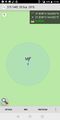
| Wed 26 Sep 2018 in -37,144: -37.8581103, 144.8525365 geohashing.info google osm bing/os kml crox |
Location
On pigface in the Altona wetlands.
Participants
Expedition
Lovely hash! Got up, saw the accessibility of this one, got on my bike and headed off towards hash, following my usual south-western bike path route.
Arriving in Spotswood, I decided to vary it up a bit, discovering new bike paths in the Seddon region by heading inland somewhat. Obviously, these bike paths had already been discovered by those who came before, but they were new to me.
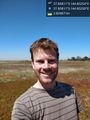
Pretty quickly I was 50m from the hash. I stepped off my bike and gingerly walked over the red and green (?) coastal pigface to arrive at the hash location. A passing cyclist eyed me curiously.
I took some ace photos of my surrounds and headed home back along the coast, stopping briefly to see the 1pm timeball fall and to have a snack lunch at a park in Williamstown, feeling impressed with the sunny weather and my ability to be submerged within it.
Here is the route of my trip.
- Geohash success! -- Felix Dance (talk) @-37.8581,144.8525 12:11, 26 September 2018 (GMT+10:00)
Photos
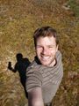
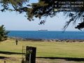
Me at the hash @-37.8581,144.8525
Proof
Squinty me at hash
My bike waiting for me
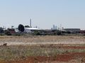
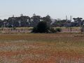
City view

Cool container ship going under the Westgate Bridge on the way to the hash
Floating boat @-37.8689,144.8959
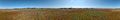
Hashorama!


More, higher resolution photos here.
Achievements
Felix Dance earned the Bicycle geohash achievement
|