Difference between revisions of "2019-02-18 -37 144"
imported>Felix Dance ([live picture]Taking the Yarra punt to work [http://www.openstreetmap.org/?lat=-37.83198650&lon=144.89591870&zoom=16&layers=B000FTF @-37.8320,144.8959]) |
m (More specific location) |
||
| (7 intermediate revisions by 2 users not shown) | |||
| Line 1: | Line 1: | ||
| − | |||
| − | |||
| − | |||
| − | |||
| − | |||
| − | |||
| − | |||
| − | |||
| − | |||
| − | |||
{{meetup graticule | {{meetup graticule | ||
| lat=-37 | | lat=-37 | ||
| Line 14: | Line 4: | ||
| date=2019-02-18 | | date=2019-02-18 | ||
}} | }} | ||
| − | |||
| − | |||
| − | |||
== Location == | == Location == | ||
| − | + | In the wall between a supermarket and a car park in central Yarraville. | |
== Participants == | == Participants == | ||
| − | + | *[[User: Felix Dance|Felix Dance]] | |
| − | + | *[[User: Lachie|Lachie]] | |
| + | |||
| + | == Expedition == | ||
| + | === Felix Dance === | ||
| + | I noticed this geohash the day before and knew I had to go for it. Strangely, I was at the geohash location that day, attending the Yarraville Festival, and almost occupied the exact same spot. | ||
| + | |||
| + | This morning, I woke up a bit earlier than usual, jumped on my bike and headed west, away from work. I reprised yesterday's route to Yarraville, and it wasn't long before I was standing outside the supermarket where the hash was located. Unfortunately, the supermarket was closed and I'd have to wait for 20 minutes before I could get in, so I looked around for a cafe. | ||
| − | + | But, having a closer look, I saw that the hash was actually virtually inside the wall between the supermarket and an open carpark next door. So I just took it from the other side. | |
| − | |||
| − | + | After uploading the photos, I decided to ride back a different way. I headed towards the public punt across the Yarra, underneath the Westgate bridge. Luckily the timing was good, because the punt was arriving at my side of the river just as I got there. I crossed the river and rode to work through Port Melbourne and St Kilda along the beach bike path. | |
| − | |||
| − | + | [https://goo.gl/maps/WtjQdLnbzgx Here] is the route of my trip. | |
| − | |||
| − | == Photos == | + | ==== Photos ==== |
<!-- Insert pictures between the gallery tags using the following format: | <!-- Insert pictures between the gallery tags using the following format: | ||
Image:2012-##-## ## ## Alpha.jpg | Witty Comment | Image:2012-##-## ## ## Alpha.jpg | Witty Comment | ||
| Line 51: | Line 41: | ||
</gallery> | </gallery> | ||
| − | |||
| − | |||
| − | |||
| − | + | === Lachie === | |
| − | + | Lachie was alerted to this geohash by Felix in the morning and determined to reach the point that afternoon on his way home from work, also in Yarraville. Since the supermarket of the hash was open at this time, he managed to get the hash from the other direction. It turned out to be inside the shelf of butter against the wall. | |
| − | + | ||
| + | It was also an opportunity for him to try out his new geohashing app he's developing. The trial was a success. | ||
| − | + | Since the deviation from Lachie's commute was minimal, this qualified as a very easy geohash. | |
| − | + | ==== Photos ==== | |
| − | < | + | <gallery perrow="5"> |
| − | |||
| − | |||
| − | + | Image:Geohash 2019-02-18 -37 144 Butter.jpeg|Geohash butter | |
| + | </gallery> | ||
| − | + | == Achievements == | |
| − | |||
| − | |||
| − | |||
| − | |||
| − | |||
| − | |||
| − | |||
| − | |||
| − | |||
| − | |||
| − | |||
| + | {{bicycle geohash | ||
| − | -- | + | | latitude = -37 |
| − | [[ | + | | longitude = 144 |
| − | + | | date = 2019-02-18 | |
| − | + | | name = [[User:Felix Dance|Felix Dance]] and [[User:Lachie|Lachie]] | |
| − | [[ | + | | distance = 19kms |
| − | + | | bothways = true | |
| − | + | | image = 2019-02-18_-37_144_Felix Dance_1550434627613.jpg | |
| − | |||
| − | + | }} | |
| − | |||
| − | |||
| − | |||
| − | |||
| − | + | [[Category:Expeditions]] | |
| + | [[Category:Expeditions with photos]] | ||
| + | [[Category:Coordinates reached]] | ||
| + | {{location|AU|VIC|MB}} | ||
Latest revision as of 12:56, 1 August 2020
| Mon 18 Feb 2019 in -37,144: -37.8165497, 144.8917731 geohashing.info google osm bing/os kml crox |
Contents
Location
In the wall between a supermarket and a car park in central Yarraville.
Participants
Expedition
Felix Dance
I noticed this geohash the day before and knew I had to go for it. Strangely, I was at the geohash location that day, attending the Yarraville Festival, and almost occupied the exact same spot.
This morning, I woke up a bit earlier than usual, jumped on my bike and headed west, away from work. I reprised yesterday's route to Yarraville, and it wasn't long before I was standing outside the supermarket where the hash was located. Unfortunately, the supermarket was closed and I'd have to wait for 20 minutes before I could get in, so I looked around for a cafe.
But, having a closer look, I saw that the hash was actually virtually inside the wall between the supermarket and an open carpark next door. So I just took it from the other side.
After uploading the photos, I decided to ride back a different way. I headed towards the public punt across the Yarra, underneath the Westgate bridge. Luckily the timing was good, because the punt was arriving at my side of the river just as I got there. I crossed the river and rode to work through Port Melbourne and St Kilda along the beach bike path.
Here is the route of my trip.
Photos
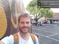
Geohash success :) @-37.8168,144.8916
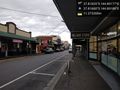
Yarraville street @-37.8166,144.8919
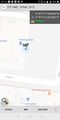
GPS proof
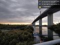
Westgate bridge near the hash @-37.8320,144.8959
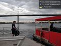
Taking the Yarra punt to work @-37.8320,144.8959


Lachie
Lachie was alerted to this geohash by Felix in the morning and determined to reach the point that afternoon on his way home from work, also in Yarraville. Since the supermarket of the hash was open at this time, he managed to get the hash from the other direction. It turned out to be inside the shelf of butter against the wall.
It was also an opportunity for him to try out his new geohashing app he's developing. The trial was a success.
Since the deviation from Lachie's commute was minimal, this qualified as a very easy geohash.
Photos
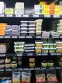
Geohash butter

Achievements
Felix Dance and Lachie earned the Bicycle geohash achievement
|