Difference between revisions of "2019-08-19 -38 145"
imported>Felix Dance ([live picture]Starting out on French Island) |
m (More specific location) |
||
| (6 intermediate revisions by 3 users not shown) | |||
| Line 1: | Line 1: | ||
| − | |||
| − | |||
| − | |||
| − | |||
| − | |||
| − | |||
| − | |||
| − | |||
| − | |||
| − | |||
{{meetup graticule | {{meetup graticule | ||
| lat=-38 | | lat=-38 | ||
| Line 14: | Line 4: | ||
| date=2019-08-19 | | date=2019-08-19 | ||
}} | }} | ||
| − | |||
| − | |||
| − | |||
== Location == | == Location == | ||
| − | + | In bush on French Island. | |
== Participants == | == Participants == | ||
| − | + | *[[User:Felix Dance|Felix Dance]] | |
| − | + | ||
| + | == Expedition == | ||
| + | I was already planning on going on a long bike ride on Monday, so when the geohash location came out I was torn about whether to make my bike ride go to French Island. In the end, yes - I decided it would. | ||
| + | |||
| + | I rode to Flinders St Station, took the train to Frankston, took another train to Stony Point, then waited for an hour for the ferry to French Island (it turns out they don't line up exactly). I got off the ferry right on midday and headed out into the sporadic rain. | ||
| + | |||
| + | The Coast Road along the west side of the island was not too bad - a sandy, unsealed road, but navigable with my fat-tyred Surly Troll. I passed a few nice beach campsites and tea tree dens. The rain was sheeting down about half the time with a cold, north-westerly wind. | ||
| + | |||
| + | Soon I got off this road and turned onto one of the muddiest, wettest 'roads' I'd ever come across. It was a mess! At times I rode through water right up to my shins, completely drenching my cycling shoes. I had the wet weather gear to cope with the rest of my body though. | ||
| − | + | A few more twists and turns and I was at closest approach to the hash. I hid my bike (not that there was any traffic) and bashed my way 60m through thick scrub to get to the hash point. I danced the hash dance finding the exact spot, took some photos and returned to my bike. | |
| − | |||
| − | + | I decided to keep circumnavigating the island. The road got a little better, but I also had to go faster, as I wanted to catch the 16:35 ferry back to the mainland. I rode over the top of the east end of the island and got a great view south to Philip Island. Soon I arrived at the south coast again. I took a short detour to see Freeman Point, where the historic prison was located (ironically), and then headed back towards the jetty. | |
| − | + | ||
| + | Annoyingly, the head wind was severe. I really had to push it (and my knees) to get back in time - the ferry left in an hour and 45 minutes. In the end I made it with 10 mins to spare, although I didn't check out French Island's only shop, in 'Tankerton' out of fear I'd miss the boat. | ||
| + | |||
| + | When I arrived back at Stony Point I hung out at the train station waiting for my 17:04 train. It never arrived. I later found out there was a mechanical failure. I washed my bike on the platform using my universal tap opener, and then rode along bike paths in the dark back to Frankston, 30kms away. I just missed a train here, so bought a fried dinner on the platform before returning home at around 9pm. | ||
| + | |||
| + | Overall a successful hash - and the first one on French Island :) | ||
| − | + | [https://goo.gl/maps/tL9q4WrdP1xMxdqw7 Here] is the map of my route of the bike ride. | |
| − | |||
== Photos == | == Photos == | ||
| − | |||
| − | |||
| − | |||
<gallery perrow="5"> | <gallery perrow="5"> | ||
| Line 51: | Line 46: | ||
Image:2019-08-19_-38_145_Felix Dance_1566187076735.jpg|Starting out on French Island | Image:2019-08-19_-38_145_Felix Dance_1566187076735.jpg|Starting out on French Island | ||
| + | |||
| + | Image:2019-08-19_-38_145_Felix Dance_1566187496786.jpg|My bike waiting for me [http://www.openstreetmap.org/?lat=-38.32413420&lon=145.39707860&zoom=16&layers=B000FTF @-38.3241,145.3971] | ||
</gallery> | </gallery> | ||
== Achievements == | == Achievements == | ||
| − | {{ | + | {{bicycle geohash |
| − | |||
| − | + | | latitude = -38 | |
| − | + | | longitude = 145 | |
| − | + | | date = 2019-08-19 | |
| + | | name = Felix Dance | ||
| + | | distance = 85kms | ||
| + | | bothways = true | ||
| + | | image = 2019-08-19_-38_145_Felix Dance_1566187076735.jpg | ||
| + | }} | ||
| − | |||
| − | |||
| − | |||
| − | |||
| − | |||
| − | |||
| − | |||
| − | |||
| − | |||
| − | |||
[[Category:Expeditions]] | [[Category:Expeditions]] | ||
| − | |||
[[Category:Expeditions with photos]] | [[Category:Expeditions with photos]] | ||
| − | |||
| − | |||
| − | |||
| − | |||
| − | |||
[[Category:Coordinates reached]] | [[Category:Coordinates reached]] | ||
| − | + | {{location|AU|VIC|FI}} | |
| − | |||
| − | |||
| − | |||
| − | |||
| − | |||
| − | |||
| − | |||
| − | |||
| − | |||
| − | |||
| − | |||
| − | |||
| − | |||
| − | |||
| − | |||
| − | |||
| − | |||
Latest revision as of 12:57, 1 August 2020
| Mon 19 Aug 2019 in -38,145: -38.3245958, 145.3970780 geohashing.info google osm bing/os kml crox |
Location
In bush on French Island.
Participants
Expedition
I was already planning on going on a long bike ride on Monday, so when the geohash location came out I was torn about whether to make my bike ride go to French Island. In the end, yes - I decided it would.
I rode to Flinders St Station, took the train to Frankston, took another train to Stony Point, then waited for an hour for the ferry to French Island (it turns out they don't line up exactly). I got off the ferry right on midday and headed out into the sporadic rain.
The Coast Road along the west side of the island was not too bad - a sandy, unsealed road, but navigable with my fat-tyred Surly Troll. I passed a few nice beach campsites and tea tree dens. The rain was sheeting down about half the time with a cold, north-westerly wind.
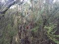
Soon I got off this road and turned onto one of the muddiest, wettest 'roads' I'd ever come across. It was a mess! At times I rode through water right up to my shins, completely drenching my cycling shoes. I had the wet weather gear to cope with the rest of my body though.
A few more twists and turns and I was at closest approach to the hash. I hid my bike (not that there was any traffic) and bashed my way 60m through thick scrub to get to the hash point. I danced the hash dance finding the exact spot, took some photos and returned to my bike.
I decided to keep circumnavigating the island. The road got a little better, but I also had to go faster, as I wanted to catch the 16:35 ferry back to the mainland. I rode over the top of the east end of the island and got a great view south to Philip Island. Soon I arrived at the south coast again. I took a short detour to see Freeman Point, where the historic prison was located (ironically), and then headed back towards the jetty.
Annoyingly, the head wind was severe. I really had to push it (and my knees) to get back in time - the ferry left in an hour and 45 minutes. In the end I made it with 10 mins to spare, although I didn't check out French Island's only shop, in 'Tankerton' out of fear I'd miss the boat.
When I arrived back at Stony Point I hung out at the train station waiting for my 17:04 train. It never arrived. I later found out there was a mechanical failure. I washed my bike on the platform using my universal tap opener, and then rode along bike paths in the dark back to Frankston, 30kms away. I just missed a train here, so bought a fried dinner on the platform before returning home at around 9pm.
Overall a successful hash - and the first one on French Island :)
Here is the map of my route of the bike ride.
Photos
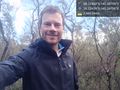
Me at the geohash @-38.3246,145.3971
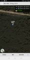
GPS proof
At The Geohash
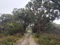
The road to the geohash
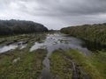
Wet terrain on French Island
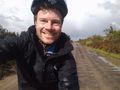
Starting out on French Island
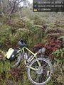
My bike waiting for me @-38.3241,145.3971


Achievements
Felix Dance earned the Bicycle geohash achievement
|