Difference between revisions of "2009-08-06 51 -113"
imported>Ekorren m (Applying template. Wondering how much later "later" will be.) |
m (More specific location) |
||
| (7 intermediate revisions by 3 users not shown) | |||
| Line 5: | Line 5: | ||
}} | }} | ||
| − | '' | + | <!-- edit as necessary --> |
| + | __NOTOC__ | ||
| + | == Location == | ||
| + | In a farm field, some kilometres south of Red Deer. | ||
| + | |||
| + | == Participants == | ||
| + | *[[User:Robyn|Robyn]] | ||
| + | |||
| + | == Plans == | ||
| + | I had bought a bicycle out of someone's back yard for about $35 and so decided to try to ride it to the nearest geohash. I said I wasn't going to go, but then I went anyway. | ||
| + | |||
| + | == Expedition == | ||
| + | <!-- how it all turned out. your narrative goes here. --> | ||
| + | It was a little windy and many of the roads were both less flat and less paved than I had expected, but there was little traffic and those vehicles that came by were extremely considerate, slowing right down and giving my lots of room to pass, although there must not have been many bicycles on those roads. The seat, pedals, handlebars and tires all remained attached to the bicycle in their original configuration. I gave a little cheer when I crossed the 51st parallel from the Red Deer into the Calgary graticule. I reached the field in which the geohash lay, but it was clearly private property, so I did not walk into it to reach the geohash. | ||
| + | |||
| + | The bicycle did not self destruct on the way back, either, and then I took it apart to fly it north to Fort Saskatchewan, where I reassembled it and gave it to [[User:Meghan|Meghan]]. | ||
| + | |||
| + | == Photos == | ||
| + | <!-- Insert pictures between the gallery tags using the following format: | ||
| + | Image:2009-##-## ## ## Alpha.jpg | Witty Comment | ||
| + | --> | ||
| + | <gallery perrow="5"> | ||
| + | Image:2009-08-06 51 -113.me.jpg |Clumsy photograph of the geohasher and her bike. | ||
| + | Image:2009-08-06 51 -113.gps.jpg|Blurry photograph of the GPS | ||
| + | Image:2010-08-06 51 -113.bike.jpg|The bike, and 572 m beyond it, the geohash. | ||
| + | </gallery> | ||
| − | |||
[[Category:Expeditions]] | [[Category:Expeditions]] | ||
| + | [[Category:Expeditions with photos]] | ||
| + | |||
| + | |||
[[Category:Coordinates not reached]] | [[Category:Coordinates not reached]] | ||
[[Category:Not reached - No public access]] | [[Category:Not reached - No public access]] | ||
| + | {{location|CA|AB|RD}} | ||
Latest revision as of 23:10, 9 August 2020
| Thu 6 Aug 2009 in 51,-113: 51.9224046, -113.7456359 geohashing.info google osm bing/os kml crox |
Location
In a farm field, some kilometres south of Red Deer.
Participants
Plans
I had bought a bicycle out of someone's back yard for about $35 and so decided to try to ride it to the nearest geohash. I said I wasn't going to go, but then I went anyway.
Expedition
It was a little windy and many of the roads were both less flat and less paved than I had expected, but there was little traffic and those vehicles that came by were extremely considerate, slowing right down and giving my lots of room to pass, although there must not have been many bicycles on those roads. The seat, pedals, handlebars and tires all remained attached to the bicycle in their original configuration. I gave a little cheer when I crossed the 51st parallel from the Red Deer into the Calgary graticule. I reached the field in which the geohash lay, but it was clearly private property, so I did not walk into it to reach the geohash.
The bicycle did not self destruct on the way back, either, and then I took it apart to fly it north to Fort Saskatchewan, where I reassembled it and gave it to Meghan.
Photos

Clumsy photograph of the geohasher and her bike.
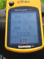
Blurry photograph of the GPS
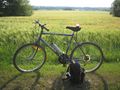
The bike, and 572 m beyond it, the geohash.


