Difference between revisions of "2009-08-15 50 -120"
imported>Rhonda's mom (New page: {{meetup graticule | map=<map lat="50" lon="-120" date="2009-08-15" /> | lat=50 | lon=-120 | date=2009-08-15 }} ==Location== In a field in Knutsford ==Participants== *[[User:Rhonda's m...) |
m (More specific location) |
||
| (3 intermediate revisions by 3 users not shown) | |||
| Line 19: | Line 19: | ||
It was time to go for a little hike again, so Rhonda's dad asked what the geohash point for the day was, and if it was accessible. We checked out a couple of possible routes on the computer to reach the point and thought that parking on Rose hill road and hiking from there would be the best way. We then decided to drive up Rose Hill road to get to Knutsford rather than take the highway. Once we reached the bend in the road that we figured we could hike from it turned out there wasn't a good place to park and there were fences between the road and the field. So on we went to the second access point. We took the Beresford road off the highway and went through an old abandoned barn yard. Just a short jaunt up the hill and we were there. The point itself was only about 7k from our house as the crow flies, but a little longer going by roads. | It was time to go for a little hike again, so Rhonda's dad asked what the geohash point for the day was, and if it was accessible. We checked out a couple of possible routes on the computer to reach the point and thought that parking on Rose hill road and hiking from there would be the best way. We then decided to drive up Rose Hill road to get to Knutsford rather than take the highway. Once we reached the bend in the road that we figured we could hike from it turned out there wasn't a good place to park and there were fences between the road and the field. So on we went to the second access point. We took the Beresford road off the highway and went through an old abandoned barn yard. Just a short jaunt up the hill and we were there. The point itself was only about 7k from our house as the crow flies, but a little longer going by roads. | ||
| + | |||
| + | ==Pictures== | ||
| + | <gallery> | ||
| + | Image:Image2009_08_15_50_-120_At_destination.jpg|Unfortunately I only took a picture of the screen that said 0 meters to go, but not proof of the actual coordinates. | ||
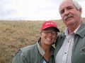
| + | Image:2009_08_15_50_-120_Goofy_grin.jpg | ||
| + | Image:2009_08_15_50_-120_Barnyard.jpg|The grass is so dry after a hot summer | ||
| + | Image:2009_08_15_50_-120_Old_trailer.jpg | ||
| + | Image:2009_08_15_50_-120_Scrap.jpg|Not sure what this was or if it is a bunch of old stuff piled together | ||
| + | Image:2009_08_15_50_-120_Who_flung_poo.jpg|I did say it was a barnyard | ||
| + | |||
| + | Image:2009_08_15_50_-120_Kamloops_lake.jpg|On top of the world while driving home | ||
| + | Image:2009_08_15_50_-120_Across_the_hill.jpg|Looking east while driving Rose hill road you can see where we live now that a lot of the pine trees are gone | ||
| + | Image:2009_08_15_50_-120_Rose_hill_water_tower.jpg|Water tower along the route | ||
| + | Image:2009_08_15_50_-120_Usual_running_trail.jpg|Standing dead pine | ||
| + | </gallery> | ||
| + | [[Category:Expeditions]] | ||
| + | [[Category:Coordinates reached]] | ||
| + | [[Category:Expeditions with photos]] | ||
| + | {{location|CA|BC|TN}} | ||
Latest revision as of 23:10, 9 August 2020
| Sat 15 Aug 2009 in 50,-120: 50.5997355, -120.2830193 geohashing.info google osm bing/os kml crox |
Contents
Location
In a field in Knutsford
Participants
- Rhonda's mom
- Rhonda's dad
Expedition
It was time to go for a little hike again, so Rhonda's dad asked what the geohash point for the day was, and if it was accessible. We checked out a couple of possible routes on the computer to reach the point and thought that parking on Rose hill road and hiking from there would be the best way. We then decided to drive up Rose Hill road to get to Knutsford rather than take the highway. Once we reached the bend in the road that we figured we could hike from it turned out there wasn't a good place to park and there were fences between the road and the field. So on we went to the second access point. We took the Beresford road off the highway and went through an old abandoned barn yard. Just a short jaunt up the hill and we were there. The point itself was only about 7k from our house as the crow flies, but a little longer going by roads.
Pictures
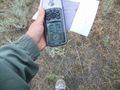
Unfortunately I only took a picture of the screen that said 0 meters to go, but not proof of the actual coordinates.
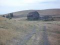
The grass is so dry after a hot summer
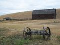
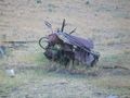
Not sure what this was or if it is a bunch of old stuff piled together
I did say it was a barnyard

On top of the world while driving home

Looking east while driving Rose hill road you can see where we live now that a lot of the pine trees are gone
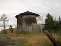
Water tower along the route

Standing dead pine


