Difference between revisions of "2013-05-28 48 -123"
From Geohashing
imported>Wijnland |
m (More specific location) |
||
| (2 intermediate revisions by 2 users not shown) | |||
| Line 23: | Line 23: | ||
== Participants == | == Participants == | ||
* [[User:Wijnland|Wijnland]] ([[User talk:Wijnland|talk]]) | * [[User:Wijnland|Wijnland]] ([[User talk:Wijnland|talk]]) | ||
| + | * Ryan | ||
| + | * Mikko | ||
| + | * Nini | ||
| + | * Adam | ||
| + | |||
<!-- who attended: If you link to your wiki user name in this section, your expedition will be picked up by the various statistics generated for geohashing. You may use three tildes ~ as a shortcut to automatically insert the user signature of the account you are editing with. | <!-- who attended: If you link to your wiki user name in this section, your expedition will be picked up by the various statistics generated for geohashing. You may use three tildes ~ as a shortcut to automatically insert the user signature of the account you are editing with. | ||
--> | --> | ||
| Line 31: | Line 36: | ||
== Expedition == | == Expedition == | ||
| + | I got a party of 5 together, we drove to the site, and did some bushwacking. The forest was dense and amazing and the phone gps would not cooperate well, so we were likely a bit off. But I still consider the expedition coordinates reached. | ||
<!-- how it all turned out. your narrative goes here. --> | <!-- how it all turned out. your narrative goes here. --> | ||
| Line 41: | Line 47: | ||
--> | --> | ||
<gallery perrow="5"> | <gallery perrow="5"> | ||
| + | Image:2013-05-28_48_-123_1.jpg | parked 100m from hash | ||
| + | Image:2013-05-28_48_-123_2.jpg | Coordinates reached | ||
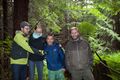
| + | Image:2013-05-28_48_-123_3.jpg | Coordinates reached | ||
</gallery> | </gallery> | ||
== Achievements == | == Achievements == | ||
{{#vardefine:ribbonwidth|800px}} | {{#vardefine:ribbonwidth|800px}} | ||
| − | + | ||
| + | {{land geohash | latitude = 48 | longitude = -123 | date = 2013-05-28 | name = Wijnland | image = 2013-05-28_48_-123_3.jpg }} | ||
| + | |||
| + | {{drag-along | ||
| + | | latitude = 48 | ||
| + | | longitude = -123 | ||
| + | | date = 2013-05-28 | ||
| + | | name = Wijnland | ||
| + | | partner = Ryan, Adam, Mikko, Nini | ||
| + | | image = 2013-05-28_48_-123_2.jpg | ||
| + | }} | ||
| − | <!-- | + | <!-- Add any achievement ribbons you earned below, or remove this section --> |
| − | |||
| − | |||
| − | |||
| − | |||
| − | |||
[[Category:Expeditions]] | [[Category:Expeditions]] | ||
-- and one or more of -- | -- and one or more of -- | ||
[[Category:Expeditions with photos]] | [[Category:Expeditions with photos]] | ||
| − | + | ||
| − | + | ||
| − | |||
| − | |||
| − | |||
[[Category:Coordinates reached]] | [[Category:Coordinates reached]] | ||
| − | + | {{location|CA|BC|CV}} | |
| − | |||
| − | |||
| − | |||
| − | |||
| − | |||
| − | |||
| − | |||
| − | |||
| − | |||
| − | |||
| − | |||
| − | |||
| − | |||
| − | |||
| − | |||
| − | |||
| − | |||
Latest revision as of 00:01, 10 August 2020
| Tue 28 May 2013 in 48,-123: 48.7864748, -123.9022623 geohashing.info google osm bing/os kml crox |
Location
Just off Riverbottom road, Cowichan Lake area
Participants
Plans
I am having a lab reatreat close to this site, so will try to round up some people for a quick hash between 5 an 6PM
Expedition
I got a party of 5 together, we drove to the site, and did some bushwacking. The forest was dense and amazing and the phone gps would not cooperate well, so we were likely a bit off. But I still consider the expedition coordinates reached.
Tracklog
Photos
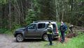
parked 100m from hash
Coordinates reached

Coordinates reached


Achievements
Wijnland earned the Land geohash achievement
|
Wijnland earned the Drag-along achievement
|
-- and one or more of --