Difference between revisions of "2015-07-25 45 -75"
imported>Jlam (An expedition message sent via Geohash Droid for Android.) |
m (More specific location) |
||
| (8 intermediate revisions by 2 users not shown) | |||
| Line 2: | Line 2: | ||
<!-- If you did not specify these parameters in the template, please substitute appropriate values for IMAGE, LAT, LON, and DATE (YYYY-MM-DD format) | <!-- If you did not specify these parameters in the template, please substitute appropriate values for IMAGE, LAT, LON, and DATE (YYYY-MM-DD format) | ||
| − | [[Image:{{{image| | + | [[Image:{{{image|2015-07-25_45_-75_jlam_1437870894120.jpg}}}|thumb|left]] |
Remove this section if you don't want an image at the top (left) of your report. You should remove the "Image:" or "File:" | Remove this section if you don't want an image at the top (left) of your report. You should remove the "Image:" or "File:" | ||
| Line 19: | Line 19: | ||
== Location == | == Location == | ||
| − | + | ||
| + | Bujold Ct in Kanata | ||
== Participants == | == Participants == | ||
| − | + | ||
| − | + | * [[User:Jlam|Jlam]] ([[User talk:Jlam|talk]]) | |
== Plans == | == Plans == | ||
| − | + | ||
| + | I had reserved VrtuCar's Nissan Leaf for the weekend. Noticed the geohash was within range of the 100% electric Leaf so I went. | ||
== Expedition == | == Expedition == | ||
<!-- how it all turned out. your narrative goes here. --> | <!-- how it all turned out. your narrative goes here. --> | ||
| − | + | As I turned onto to Bujold Ct, I noticed the no trespassing sign. However I decided to proceed as although it was a private road, it was not a personal road. Went arround the Ct to confirm the location of the hash. Parked in the visitors parking. Went to the coordinates and took the picture. | |
| − | + | ||
| + | The rerurn trip was interesting. I had decided to stop at the Library on Campeau Dr as Nissan's car wings service was showing a recharging station there. Turns out to be a very good station. I had now have a very good way point if we want to take a road trip out west or north west with the 100% electric leaf as I'm guessing there is wifi at the Library. | ||
== Photos == | == Photos == | ||
| Line 39: | Line 42: | ||
--> | --> | ||
<gallery perrow="5"> | <gallery perrow="5"> | ||
| − | |||
| − | == | + | Image:2015-07-25_45_-75_jlam_1437870894120.jpg | Bujold Cr. [http://www.openstreetmap.org/?lat=45.30680000&lon=-75.88880000&zoom=16&layers=B000FTF @45.3068,-75.8888] |
| − | |||
| − | |||
| − | + | Image:2015-07-25_45_-75_jlam_1437870857999.jpg | Bujold Cr. [http://www.openstreetmap.org/?lat=45.30680000&lon=-75.88880000&zoom=16&layers=B000FTF @45.3068,-75.8888] | |
| − | + | </gallery> | |
| − | |||
| − | |||
| − | |||
| − | < | ||
| − | |||
| − | |||
| − | |||
| − | |||
[[Category:Expeditions]] | [[Category:Expeditions]] | ||
| − | |||
[[Category:Expeditions with photos]] | [[Category:Expeditions with photos]] | ||
| − | |||
| − | |||
| − | |||
| − | |||
| − | |||
[[Category:Coordinates reached]] | [[Category:Coordinates reached]] | ||
| − | + | {{location|CA|ON|OT}} | |
| − | |||
| − | |||
| − | |||
| − | |||
| − | |||
| − | |||
| − | |||
| − | |||
| − | |||
| − | |||
| − | |||
| − | |||
| − | |||
| − | |||
| − | |||
| − | |||
| − | |||
Latest revision as of 00:10, 10 August 2020
| Sat 25 Jul 2015 in 45,-75: 45.3067980, -75.8888245 geohashing.info google osm bing/os kml crox |
Location
Bujold Ct in Kanata
Participants
Plans
I had reserved VrtuCar's Nissan Leaf for the weekend. Noticed the geohash was within range of the 100% electric Leaf so I went.
Expedition
As I turned onto to Bujold Ct, I noticed the no trespassing sign. However I decided to proceed as although it was a private road, it was not a personal road. Went arround the Ct to confirm the location of the hash. Parked in the visitors parking. Went to the coordinates and took the picture.
The rerurn trip was interesting. I had decided to stop at the Library on Campeau Dr as Nissan's car wings service was showing a recharging station there. Turns out to be a very good station. I had now have a very good way point if we want to take a road trip out west or north west with the 100% electric leaf as I'm guessing there is wifi at the Library.
Photos
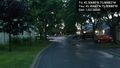
Bujold Cr. @45.3068,-75.8888

Bujold Cr. @45.3068,-75.8888
