Difference between revisions of "2018-02-26 43 -79"
imported>Frogman (→Plans) |
m (More specific location) |
||
| (5 intermediate revisions by 4 users not shown) | |||
| Line 19: | Line 19: | ||
== Location == | == Location == | ||
| − | + | The location was in a parking lot to Wismer Park along Castlemore Ave. in Markham. | |
== Participants == | == Participants == | ||
<!-- who attended: If you link to your wiki user name in this section, your expedition will be picked up by the various statistics generated for geohashing. You may use three tildes ~ as a shortcut to automatically insert the user signature of the account you are editing with. | <!-- who attended: If you link to your wiki user name in this section, your expedition will be picked up by the various statistics generated for geohashing. You may use three tildes ~ as a shortcut to automatically insert the user signature of the account you are editing with. | ||
--> | --> | ||
| + | *[[User:Splitdipless|Splitdipless]] ([[User talk:Splitdipless|talk]]) | ||
== Plans == | == Plans == | ||
| Line 31: | Line 32: | ||
== Expedition == | == Expedition == | ||
| − | + | === [[User:Splitdipless|Splitdipless]] ([[User talk:Splitdipless|talk]]) === | |
| + | I had some errands to run after work, so I ended up taking a sunset drive through the country just North of work, and then a bit as I was heading West. Eventually, suburbia started cropping up around as I got nearer. Fortunately, it looked like the hash was delivering me to a parking lot, so parking was not an issue. | ||
== Tracklog == | == Tracklog == | ||
| Line 41: | Line 43: | ||
--> | --> | ||
<gallery perrow="5"> | <gallery perrow="5"> | ||
| + | Image:2018-02-26 43 -79 A.jpg | It would probably look nicer in daylight. | ||
| + | Image:2018-02-26 43 -79 B.jpg | Stupid grin, as required. | ||
| + | Image:2018-02-26 43 -79 C.png | I'm liking this app. It's a lot easier than the early days. | ||
</gallery> | </gallery> | ||
| Line 46: | Line 51: | ||
{{#vardefine:ribbonwidth|800px}} | {{#vardefine:ribbonwidth|800px}} | ||
<!-- Add any achievement ribbons you earned below, or remove this section --> | <!-- Add any achievement ribbons you earned below, or remove this section --> | ||
| + | {{land geohash | ||
| − | <!-- = | + | | latitude = 43 |
| − | + | | longitude = -79 | |
| − | + | | date = 2018-02-26 | |
| + | | name = Splitdipless | ||
| + | <!-- | image = image name (optional) --> | ||
| − | + | }} | |
<!-- Potential categories. Please include all the ones appropriate to your expedition --> | <!-- Potential categories. Please include all the ones appropriate to your expedition --> | ||
| − | |||
| − | |||
| − | |||
| − | |||
| − | |||
| − | |||
[[Category:Expeditions]] | [[Category:Expeditions]] | ||
| − | |||
[[Category:Expeditions with photos]] | [[Category:Expeditions with photos]] | ||
| − | |||
| − | |||
| − | |||
| − | |||
| − | |||
[[Category:Coordinates reached]] | [[Category:Coordinates reached]] | ||
| − | + | {{location|CA|ON|YO}} | |
| − | |||
| − | |||
| − | |||
| − | |||
| − | |||
| − | |||
| − | |||
| − | |||
| − | |||
| − | |||
| − | |||
| − | |||
| − | |||
| − | |||
| − | |||
| − | |||
| − | |||
Latest revision as of 00:15, 10 August 2020
| Mon 26 Feb 2018 in 43,-79: 43.9002347, -79.2808176 geohashing.info google osm bing/os kml crox |
Location
The location was in a parking lot to Wismer Park along Castlemore Ave. in Markham.
Participants
Plans
I'm in Pickering, and I live in North York, so an expedition to Markham isn't too difficult. Splitdipless (talk) 15:18, 26 February 2018 (UTC)
I'm also planning on swinging by this at some point today. Frogman (talk) 17:43, 26 February 2018 (UTC)
Expedition
Splitdipless (talk)
I had some errands to run after work, so I ended up taking a sunset drive through the country just North of work, and then a bit as I was heading West. Eventually, suburbia started cropping up around as I got nearer. Fortunately, it looked like the hash was delivering me to a parking lot, so parking was not an issue.
Tracklog
Photos
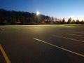
It would probably look nicer in daylight.

Stupid grin, as required.
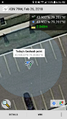
I'm liking this app. It's a lot easier than the early days.


Achievements
Splitdipless earned the Land geohash achievement
|