Difference between revisions of "2020-08-03 48 -117"
([retro picture]Overlook Northport and Columbia River) |
m (Location correction) |
||
| Line 51: | Line 51: | ||
[[Category:Expeditions with photos]] | [[Category:Expeditions with photos]] | ||
[[Category:Coordinates reached]] | [[Category:Coordinates reached]] | ||
| − | {{location|US|WA| | + | {{location|US|WA|ST}} |
Latest revision as of 07:12, 1 September 2020
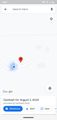
| Mon 3 Aug 2020 in Colville: 48.8888431, -117.7266647 geohashing.info google osm bing/os kml crox |
Location
A driveway near Northport
Participants
Plans
Quick drive from the campsite - with AC!
Expedition
Very spotty (Tmobile) internet access, so I took screenshots in the expectation that I wouldn't be able to upload. AT&T is apparently better, but you go with what you have.
Drove directly south from Northport, which is also up and above. Took a nice picture of the view. Continued on to the driveway in question.
Did not look like anyone was home, and in the time of COVID I am unlikely to knock on the door. Driveway had a sign that video recording was in progress, so perhaps my image appears on a server somewhere else.
Drove in, turned around quite near the spot, then drove out, grabbing another screenshot or two on the way.
Tracklog
Photos

Top of driveway
From open street map

Turn around spot
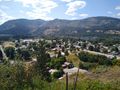
Overlook Northport and Columbia River


