Difference between revisions of "2015-11-08 -12 131"
imported>Felix Dance (Added text) |
m (Location correction) |
||
| (6 intermediate revisions by 3 users not shown) | |||
| Line 1: | Line 1: | ||
| + | [[Image:{{{image|Geohash 2015-11-08 -12 131 05 Stout.JPG}}}|thumb|left]] | ||
| + | |||
{{meetup graticule | {{meetup graticule | ||
| lat=-12 | | lat=-12 | ||
| lon=131 | | lon=131 | ||
| − | | date=2015-11- | + | | date=2015-11-08 |
}} | }} | ||
__NOTOC__ | __NOTOC__ | ||
== Location == | == Location == | ||
| − | On a hillside in the bush near the road from the Stuart Highway to Marakai, opposite | + | '''100th Successful Geohash!''' On a hillside in the bush near the road from the Stuart Highway to Marakai, opposite Marton Dam. |
== Participants == | == Participants == | ||
| Line 15: | Line 17: | ||
Saturday brought my attention to this one. A bit of a no-brainer, really. I'd been sitting on 99 successful geohashes for a couple of weeks and had my eye out for a worthy 100th - this was the opportunity. | Saturday brought my attention to this one. A bit of a no-brainer, really. I'd been sitting on 99 successful geohashes for a couple of weeks and had my eye out for a worthy 100th - this was the opportunity. | ||
| − | Having slept in a bit, I left the house at 8am on my dilapidated road bike and rode down the old Katherine Rail Trail to Finlay's Joint at Palmerston. Here | + | Having slept in a bit, I left the house at 8am on my dilapidated road bike and rode down the old Katherine Rail Trail to Finlay's Joint at Palmerston. Here I luxuriated in a long, eggy breakfast reading The Saturday Paper before venturing on towards the hash. |
| − | Rather than take my usual circumperambulating route through Berry Springs like usual, I went straight at it down the Stuart Highway, carefully not freaking out when road-trains passed by | + | Rather than take my usual circumperambulating route through Berry Springs like usual, I went straight at it down the Stuart Highway, carefully not freaking out when road-trains passed me by, snaking and swaying all over the road as they do. |
| − | At Acacia Springs I stopped off at a servo to refuel my | + | At Acacia Springs I stopped off at a servo to refuel my water stocks, it having reached 38 degrees C and fluctuating between 40 and 80 percent humidity. I stashed one of my drink bottles in the ice-bag cooler for the ride home, all the while chortling at my own brilliance for having thought of this. Unfortunately, my mood was somewhat dampened by the 'Reduced-to-clear' basket containing post-used-by-date muesli bars that were in fact sold at full price - I'd left the shop by the time I'd realised this. I believe this problem to be universal, rather than just being confined to the First World. |
After another hour or so, in which I rode through the intense heat along the highway while fretting about having somehow completely stuffed up the transcription of the geohash coordinates to my GPS and relying on non-existent phone reception for accurate positioning, I hit the turnoff to Marakai. It was a dusty, corrugated dirt road winding deep into the bush. After a couple of kms, and just before I was about to turn left to trek through the wilderness for the hash, my phone suddenly (bizarrely) regained full 4G reception, so I was able to get the coordinates and correctly turn RIGHT for the hash, all the while live-messaging my approach to fellow-geohasher [[User:Lachie|Lachie]] in Melbourne. | After another hour or so, in which I rode through the intense heat along the highway while fretting about having somehow completely stuffed up the transcription of the geohash coordinates to my GPS and relying on non-existent phone reception for accurate positioning, I hit the turnoff to Marakai. It was a dusty, corrugated dirt road winding deep into the bush. After a couple of kms, and just before I was about to turn left to trek through the wilderness for the hash, my phone suddenly (bizarrely) regained full 4G reception, so I was able to get the coordinates and correctly turn RIGHT for the hash, all the while live-messaging my approach to fellow-geohasher [[User:Lachie|Lachie]] in Melbourne. | ||
| − | Clomping around a hill I reached the point, cracked my home-brought | + | Clomping around a hill I reached the point, cracked my home-brought homebrew stout for the big One-O-O, and feverishly shared the experience to Facebook denizens the world over. Quietly, I contemplated my [[2008-06-21 -37 145|geohash #1]] and how far I've come since then. Pretty much nowhere. |
| − | I returned to 'civilisation' via a view of Marton Dam, the Berry Springs non-road-trainy route, a cracking sunset over the Inpex Gas Plant | + | I returned to 'civilisation' via a view of Marton Dam, the Berry Springs non-road-trainy route, a cracking sunset over the Inpex Gas Plant beyond Elizabeth River and a lamb kebab in Berrimer. Oh, and I got a flat outside Acacia Springs on the way back, which was a bit of a bitch. |
All up, I rode 175 kms. [https://goo.gl/maps/NHnaPLZ6oK22 Here] is my route. | All up, I rode 175 kms. [https://goo.gl/maps/NHnaPLZ6oK22 Here] is my route. | ||
| Line 31: | Line 33: | ||
== Photos == | == Photos == | ||
<gallery perrow="6"> | <gallery perrow="6"> | ||
| + | Image:Geohash 2015-11-08 -12 131 01 Highway.JPG|Stuart Highway<br/> | ||
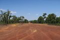
| + | Image:Geohash 2015-11-08 -12 131 02 Dirt.JPG|Turn-off to Marakai<br/> | ||
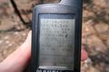
| + | Image:Geohash 2015-11-08 -12 131 03 GPS.JPG|GPS Proof<br/> | ||
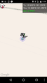
| + | Image:Geohash 2015-11-08 -12 131 10 Phone.png|Phone GPS<br/> | ||
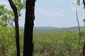
| + | Image:Geohash 2015-11-08 -12 131 04 View.JPG|View from Geohash Mons<br/> | ||
| + | Image:Geohash 2015-11-08 -12 131 05 Stout.JPG|100th Successful Geohash Stout!<br/> | ||
| + | Image:Geohash 2015-11-08 -12 131 06 Dam.JPG|Marton Dam<br/> | ||
| + | Image:Geohash 2015-11-08 -12 131 07 Inpex.JPG|The Inpex Gas Plant<br/> | ||
| + | Image:Geohash 2015-11-08 -12 131 08 Sunset.JPG|Sunset on the way home<br/> | ||
| + | Image:Geohash 2015-11-08 -12 131 09 Felix.JPG|Tired-out Felix at night<br/> | ||
| + | </gallery> | ||
| + | |||
| + | == Audio == | ||
| + | [https://drive.google.com/open?id=0B3IN-7Bbq6SDYUowY19SQjdpRjg Hashsounds] | ||
| − | + | == Awards == | |
{{bicycle geohash | {{bicycle geohash | ||
| Line 42: | Line 58: | ||
| distance = 175 kms | | distance = 175 kms | ||
| bothways = TRUE | | bothways = TRUE | ||
| − | | image = Geohash 2015-11-08 -12 131 | + | | image = Geohash 2015-11-08 -12 131 09 Felix.JPG |
}} | }} | ||
| Line 48: | Line 64: | ||
[[Category:Expeditions with photos]] | [[Category:Expeditions with photos]] | ||
[[Category:Coordinates reached]] | [[Category:Coordinates reached]] | ||
| + | {{location|AU|NT|CO}} | ||
Latest revision as of 14:32, 4 October 2020

| Sun 8 Nov 2015 in -12,131: -12.9053471, 131.1586973 geohashing.info google osm bing/os kml crox |
Location
100th Successful Geohash! On a hillside in the bush near the road from the Stuart Highway to Marakai, opposite Marton Dam.
Participants
Expedition
Saturday brought my attention to this one. A bit of a no-brainer, really. I'd been sitting on 99 successful geohashes for a couple of weeks and had my eye out for a worthy 100th - this was the opportunity.
Having slept in a bit, I left the house at 8am on my dilapidated road bike and rode down the old Katherine Rail Trail to Finlay's Joint at Palmerston. Here I luxuriated in a long, eggy breakfast reading The Saturday Paper before venturing on towards the hash.
Rather than take my usual circumperambulating route through Berry Springs like usual, I went straight at it down the Stuart Highway, carefully not freaking out when road-trains passed me by, snaking and swaying all over the road as they do.
At Acacia Springs I stopped off at a servo to refuel my water stocks, it having reached 38 degrees C and fluctuating between 40 and 80 percent humidity. I stashed one of my drink bottles in the ice-bag cooler for the ride home, all the while chortling at my own brilliance for having thought of this. Unfortunately, my mood was somewhat dampened by the 'Reduced-to-clear' basket containing post-used-by-date muesli bars that were in fact sold at full price - I'd left the shop by the time I'd realised this. I believe this problem to be universal, rather than just being confined to the First World.
After another hour or so, in which I rode through the intense heat along the highway while fretting about having somehow completely stuffed up the transcription of the geohash coordinates to my GPS and relying on non-existent phone reception for accurate positioning, I hit the turnoff to Marakai. It was a dusty, corrugated dirt road winding deep into the bush. After a couple of kms, and just before I was about to turn left to trek through the wilderness for the hash, my phone suddenly (bizarrely) regained full 4G reception, so I was able to get the coordinates and correctly turn RIGHT for the hash, all the while live-messaging my approach to fellow-geohasher Lachie in Melbourne.
Clomping around a hill I reached the point, cracked my home-brought homebrew stout for the big One-O-O, and feverishly shared the experience to Facebook denizens the world over. Quietly, I contemplated my geohash #1 and how far I've come since then. Pretty much nowhere.
I returned to 'civilisation' via a view of Marton Dam, the Berry Springs non-road-trainy route, a cracking sunset over the Inpex Gas Plant beyond Elizabeth River and a lamb kebab in Berrimer. Oh, and I got a flat outside Acacia Springs on the way back, which was a bit of a bitch.
All up, I rode 175 kms. Here is my route.
Photos

Stuart Highway
Turn-off to Marakai
GPS Proof
Phone GPS
View from Geohash Mons
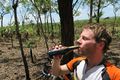
100th Successful Geohash Stout!
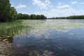
Marton Dam

The Inpex Gas Plant
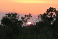
Sunset on the way home

Tired-out Felix at night


Audio
Awards
Felix Dance earned the Bicycle geohash achievement
|