Difference between revisions of "2015-04-02 52 9"
imported>Fippe ({{location|DE|NI|H}} Category:Expeditions by Fippe) |
m (Format) |
||
| Line 32: | Line 32: | ||
==Achievements== | ==Achievements== | ||
| − | {{#vardefine:ribbonwidth| | + | {{#vardefine:ribbonwidth|100%}} |
{{land geohash|latitude=52|longitude=9|date=2015-04-02|name=[[User:Fippe|Fippe]]|image=2015-04-02 52 09 03 Geohash.jpg}} | {{land geohash|latitude=52|longitude=9|date=2015-04-02|name=[[User:Fippe|Fippe]]|image=2015-04-02 52 09 03 Geohash.jpg}} | ||
Revision as of 17:54, 13 October 2020
| Thu 2 Apr 2015 in Hannover: 52.2805713, 9.6952112 geohashing.info google osm bing/os kml crox |
Location
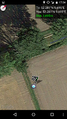
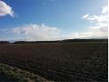
The Geohash is located next to a river on a field near Hiddestorf.
Participants
Plans
I planned to go to Hiddestorf by bus, then grab the Geohash and go back the same way.
Expedition
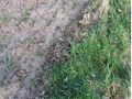
The way to the geohash was nice. After getting of the bus, I followed the small river Arnumer Landwehr, eventually crossed it and found the hash nearby. It was on a border between to fields, one plowed and one green.
Unfortunately I was to slow on my way back, so I just missed my bus for a single minute. I decided go the 4km back to the main road in Arnum by foot, because the bus only stops once in a hour. In Arnum, busses stop more frequently, and from there I got back home.
Photos

Proof
Proof
The Geohash
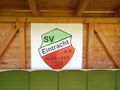
The local sports club's coat of arms
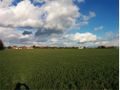
Landscape
Landscape


Achievements
Fippe earned the Land geohash achievement
|
I relinquish my former claim on the last man standing achievement for this day, because more than three years later Michael5000 and Jennifer documented their expedition on the same day.