Difference between revisions of "2020-10-04 47 8"
m (Location) |
(→Tracklog) |
||
| (8 intermediate revisions by 2 users not shown) | |||
| Line 9: | Line 9: | ||
== Participants == | == Participants == | ||
| − | [[User:Tungmar|Tungmar]] ([[User talk:Tungmar|talk]]) | + | * [[User:Tungmar|Tungmar]] ([[User talk:Tungmar|talk]]) |
== Plans == | == Plans == | ||
| Line 18: | Line 18: | ||
The trip was uneventful. | The trip was uneventful. | ||
| + | |||
| + | I did add the pond and a barely visible track to OSM. Here is [https://www.openstreetmap.org/changeset/92002682#map=19/47.39179/8.37447 my commit]. | ||
== Tracklog == | == Tracklog == | ||
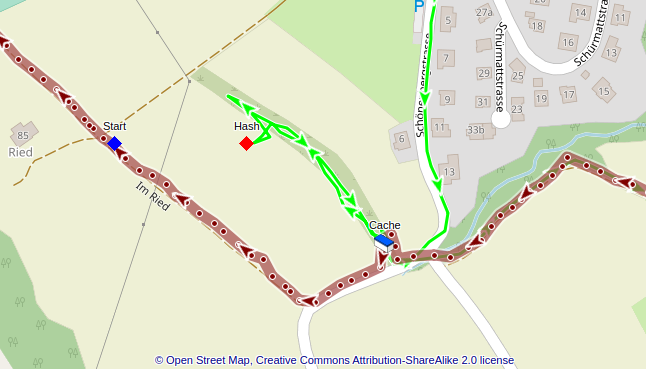
[[File:2020-10-04 47 8 Trackshot.png]] | [[File:2020-10-04 47 8 Trackshot.png]] | ||
| − | Red is the track from Friday, green the one from Sunday. | + | Red is the track from Friday, green the one from Sunday. Ths blue rhombus marks my location when I got to know about this geohash. |
== Photos == | == Photos == | ||
| Line 33: | Line 35: | ||
Image:2020-10-04 47 8 View 2.jpeg|View from the hashpoint | Image:2020-10-04 47 8 View 2.jpeg|View from the hashpoint | ||
Image:2020-10-04 47 8 View 3.jpeg|View from the hashpoint | Image:2020-10-04 47 8 View 3.jpeg|View from the hashpoint | ||
| − | Image:2020-10-04 47 8 View to Cache.jpeg|View from the hashpoint towards the GeoCache. | + | Image:2020-10-04 47 8 View to Cache.jpeg|View from the hashpoint towards the GeoCache. |
| − | Image:2020-10-04 47 8 View from Cache.jpeg|Bad bad picture, but through the bush the hashsite was clearly visible. | + | Image:2020-10-04 47 8 View from Cache.jpeg|Bad bad picture, but through the bush the hashsite was clearly visible. The N is the nice cover of the cache! |
Image:2020-10-04 47 8 Cache Log.jpeg|My two entries in to the log of the cache. | Image:2020-10-04 47 8 Cache Log.jpeg|My two entries in to the log of the cache. | ||
Image:2020-10-04 47 8 Cows.jpeg|On the way back, I meet some cows. | Image:2020-10-04 47 8 Cows.jpeg|On the way back, I meet some cows. | ||
| Line 42: | Line 44: | ||
== Achievements == | == Achievements == | ||
{{#vardefine:ribbonwidth|800px}} | {{#vardefine:ribbonwidth|800px}} | ||
| − | + | {{OpenStreetMap achievement | |
| + | | latitude = 47 | ||
| + | | longitude = 8 | ||
| + | | date = 2020-10-04 | ||
| + | | OSMlink = 92002682 | ||
| + | | name = [[User:Tungmar|Tungmar]] ([[User talk:Tungmar|talk]]) | ||
| + | }} | ||
| + | {{Hash collision | latitude = 47 | longitude = 8 | date = 2020-10-04 | name = [[User:Tungmar|Tungmar]] ([[User talk:Tungmar|talk]]) | id = GC4YGJE | link = https://coord.info/GC4YGJE | distance = 139m}} | ||
| + | {{Radio Yerevan | ||
| + | |achievement = [[Déjà Vu Geohash|Déjà-vu geohash achievement]] | ||
| + | |detail = "Downy" was to fast for him | ||
| + | |date = 2020-10-04 | ||
| + | |latitude = 47 | ||
| + | |longitude = 8 | ||
| + | |user = [[User:Tungmar|Tungmar]] ([[User talk:Tungmar|talk]]) | ||
| + | }} | ||
| − | <!-- =============== USEFUL CATEGORIES FOLLOW ================ | + | <!-- =============== USEFUL CATEGORIES FOLLOW ================ --> |
[[Category:Expeditions]] | [[Category:Expeditions]] | ||
[[Category:Expeditions with photos]] | [[Category:Expeditions with photos]] | ||
[[Category:Coordinates reached]] | [[Category:Coordinates reached]] | ||
{{location|CH|AG}} | {{location|CH|AG}} | ||
Latest revision as of 17:08, 13 November 2020
| Sun 4 Oct 2020 in 47,8: 47.3921119, 8.3739426 geohashing.info google osm bing/os kml crox |
Location
On a field near Kindhausen.
Participants
Plans
Take the bus 305 to Kindhausen and walk to the hashpoint - like two days ago.
Expedition
Two days ago I visited the GeoCache GC4YGJE Der Nachtwächter. Soon later I checked the website to see where the Geohashes for the weekend are. The one for Sunday was just a few meters away and in plain sight! With the clock at 17:28+02:00 the hashes where already 2h out however. Any way, today I had to visit the place again. Just for the memory of this coincidence. Near the hash is a tiny pond a bit hidden. It's a nice location - on Sundays: There is a army shooting range near by and they are quiet loud with all that explosives they "test" there.
The trip was uneventful.
I did add the pond and a barely visible track to OSM. Here is my commit.
Tracklog
Red is the track from Friday, green the one from Sunday. Ths blue rhombus marks my location when I got to know about this geohash.
Photos
Achievements
Tungmar (talk) earned the OpenStreetMap achievement
|
Tungmar (talk) earned the Hash collision achievement
|
Is it true that Tungmar (talk) earned the Déjà-vu geohash achievement?
|


