Difference between revisions of "2013-06-01 52 9"
imported>Oliver |
m (Linking to The Dance™) |
||
| (4 intermediate revisions by 3 users not shown) | |||
| Line 1: | Line 1: | ||
| − | |||
| − | |||
| − | |||
| − | |||
| − | |||
| − | |||
| − | |||
| − | |||
| − | |||
| − | |||
{{meetup graticule | {{meetup graticule | ||
| lat=52 | | lat=52 | ||
| Line 15: | Line 5: | ||
}} | }} | ||
| − | |||
__NOTOC__ | __NOTOC__ | ||
== Location == | == Location == | ||
| Line 27: | Line 16: | ||
== Expedition == | == Expedition == | ||
| − | + | Cycled to Bremen main station and took the 14:19h train, which arrived in Nienburg/Weser around 15:00h. Cycled through the city and got lost a bit (that's what you get from completely relying on your GPS), and hence got a good look at the city which is quite beautiful with lots of little streets and shops. Finally got into the open fields and leisurely cycled towards the hashpoint. It was located in a meadow with high grass (luckily - if it had been a few meters south, it would have been in some crop field). Being in the midst of the meadow, GPS reception was perfect, and [[The Dance™|the dance]] was really easy (every step was exactly visible on the display). Wrote a marker and left it at a fencepost, then went back to the bike and had some cookies; and as it was 16:00h just then, I rode off. | |
| − | Cycled to Bremen main station and took the 14:19h train, which arrived in Nienburg/Weser around 15:00h. Cycled through the city and got lost a bit (that's what you get from completely relying on your GPS), and hence got a good look at the city which is quite beautiful with lots of little streets and shops. Finally got into the open fields and leisurely cycled towards the hashpoint. It was located in a meadow with high grass (luckily - if it had been a few meters south, it would have been in some crop field). Being in the midst of the meadow, GPS reception was perfect, and the dance was really easy (every step was exactly visible on the display). Wrote a marker and left it at a fencepost, then went back to the bike and had some cookies; and as it was 16:00h just then, I rode off. | ||
For the way home I had already noticed that the "Weserradweg" (national cycling way along Weser river) passed some kilometers north of the hashpoint, so I went there and then just followed the signs. It was mostly uneventful, except when I lost the track near Achim and then in addition hit a flooded road. Having all materials for a geohash marker in the backpack anyway, I was able to set up some makeshift detour sign a few kilometers earlier, so other cyclists wouldn't have to go all the way to the blockade. As it was late already, I then stopped in Achim for some baguette, and finally got home by about 22:00h. All in all not very adventurous, but a nice trip anyway. | For the way home I had already noticed that the "Weserradweg" (national cycling way along Weser river) passed some kilometers north of the hashpoint, so I went there and then just followed the signs. It was mostly uneventful, except when I lost the track near Achim and then in addition hit a flooded road. Having all materials for a geohash marker in the backpack anyway, I was able to set up some makeshift detour sign a few kilometers earlier, so other cyclists wouldn't have to go all the way to the blockade. As it was late already, I then stopped in Achim for some baguette, and finally got home by about 22:00h. All in all not very adventurous, but a nice trip anyway. | ||
| Line 34: | Line 22: | ||
== Photos == | == Photos == | ||
| − | |||
| − | |||
| − | |||
<gallery perrow="5"> | <gallery perrow="5"> | ||
| + | Image:Geohash-2013-06-01-grat-52-9-nienburg-2s.jpg | View from the hashpoint | ||
| + | Image:Geohash-2013-06-01-grat-52-9-nienburg-3s.jpg | Here we are! | ||
| + | Image:Geohash-2013-06-01-grat-52-9-nienburg-1s2.jpg | Left a note | ||
| + | Image:Geohash-2013-06-01-grat-52-9-nienburg-4s.jpg | Back on track (bicycle in the background) | ||
</gallery> | </gallery> | ||
== Achievements == | == Achievements == | ||
{{#vardefine:ribbonwidth|800px}} | {{#vardefine:ribbonwidth|800px}} | ||
| − | |||
| + | {{land geohash | ||
| + | | latitude = 52 | ||
| + | | longitude = 9 | ||
| + | | date = 2013-06-01 | ||
| + | | name = Oliver | ||
| + | | image = Geohash-2013-06-01-grat-52-9-nienburg-1s2.jpg | ||
| + | }} | ||
| + | {{Minesweeper geohash | ||
| + | | graticule = Bremen, Germany | ||
| + | | ranknumber = 2 | ||
| + | | se = true | ||
| + | | s = true | ||
| + | | name = Oliver | ||
| + | }} | ||
| − | |||
| − | |||
| − | |||
| − | |||
| − | |||
| − | |||
| − | |||
| − | |||
| − | |||
| − | |||
[[Category:Expeditions]] | [[Category:Expeditions]] | ||
| − | |||
[[Category:Expeditions with photos]] | [[Category:Expeditions with photos]] | ||
| − | |||
| − | |||
| − | |||
| − | |||
| − | |||
[[Category:Coordinates reached]] | [[Category:Coordinates reached]] | ||
| − | + | {{location|DE|NI|NI}} | |
| − | |||
| − | |||
| − | |||
| − | |||
| − | |||
| − | |||
| − | |||
| − | |||
| − | |||
| − | |||
| − | |||
| − | |||
| − | |||
| − | |||
| − | |||
| − | |||
| − | |||
Latest revision as of 17:00, 14 November 2020
| Sat 1 Jun 2013 in 52,9: 52.6477531, 9.1495333 geohashing.info google osm bing/os kml crox |
Location
On a field near Nienburg/Weser.
Participants
Plans
Ambitious plan: will try to get to Nienburg by train, then cycle to the geohash, then cycle back to Bremen. As the way home is quite long, I will probably leave the hashpoint before 16:00h (will try to leave a sign, however).
Expedition
Cycled to Bremen main station and took the 14:19h train, which arrived in Nienburg/Weser around 15:00h. Cycled through the city and got lost a bit (that's what you get from completely relying on your GPS), and hence got a good look at the city which is quite beautiful with lots of little streets and shops. Finally got into the open fields and leisurely cycled towards the hashpoint. It was located in a meadow with high grass (luckily - if it had been a few meters south, it would have been in some crop field). Being in the midst of the meadow, GPS reception was perfect, and the dance was really easy (every step was exactly visible on the display). Wrote a marker and left it at a fencepost, then went back to the bike and had some cookies; and as it was 16:00h just then, I rode off.
For the way home I had already noticed that the "Weserradweg" (national cycling way along Weser river) passed some kilometers north of the hashpoint, so I went there and then just followed the signs. It was mostly uneventful, except when I lost the track near Achim and then in addition hit a flooded road. Having all materials for a geohash marker in the backpack anyway, I was able to set up some makeshift detour sign a few kilometers earlier, so other cyclists wouldn't have to go all the way to the blockade. As it was late already, I then stopped in Achim for some baguette, and finally got home by about 22:00h. All in all not very adventurous, but a nice trip anyway.
Photos
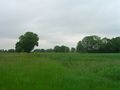
View from the hashpoint
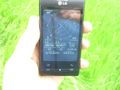
Here we are!
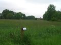
Left a note
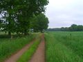
Back on track (bicycle in the background)


Achievements
Oliver earned the Land geohash achievement
|
Oliver achieved level 2 of the Minesweeper Geohash achievement
|