Difference between revisions of "2019-06-18 -35 138"
From Geohashing
imported>BrendanTWhite (Created page with "{{subst:Expedition |lat = -35 |lon = 138 |date = 2019-06-18 }}") |
|||
| (12 intermediate revisions by 3 users not shown) | |||
| Line 20: | Line 20: | ||
== Location == | == Location == | ||
<!-- where you've surveyed the hash to be --> | <!-- where you've surveyed the hash to be --> | ||
| + | [http://maps.google.com/maps?q=-35.0170359%2C%20138.6251473 -35.0170359, 138.6251473] | ||
| + | |||
| + | This Geohash is located in Hawthorndene, a suburb in the leafy foothills of the [https://en.wikipedia.org/wiki/Adelaide_Hills Adelaide hills]. | ||
== Participants == | == Participants == | ||
<!-- who attended: If you link to your wiki user name in this section, your expedition will be picked up by the various statistics generated for geohashing. You may use three tildes ~ as a shortcut to automatically insert the user signature of the account you are editing with. | <!-- who attended: If you link to your wiki user name in this section, your expedition will be picked up by the various statistics generated for geohashing. You may use three tildes ~ as a shortcut to automatically insert the user signature of the account you are editing with. | ||
--> | --> | ||
| − | + | Just me, [[User:BrendanTWhite|BrendanTWhite]] ([[User talk:BrendanTWhite|talk]]), and my daughter. | |
| − | |||
| − | |||
== Expedition == | == Expedition == | ||
<!-- how it all turned out. your narrative goes here. --> | <!-- how it all turned out. your narrative goes here. --> | ||
| + | We just drove over there - it's only a fairly short drive from our house - and took a couple of photos. | ||
| + | |||
| + | The actual point was in the front garden of someone's home, so we just got as close as we could without trespassing. | ||
| − | + | The good part is that the kiddo now wants to do more geohashing whenever the point is close enough! :-) | |
| − | |||
== Photos == | == Photos == | ||
| Line 39: | Line 42: | ||
--> | --> | ||
<gallery perrow="5"> | <gallery perrow="5"> | ||
| + | Image: 2019-06 18 -35 138 gps.png | The Proof | ||
| + | Image: 2019-06 18 -35 138 pergola.jpg | The pergola | ||
| + | Image: 2019-06 18 -35 138 house.jpg | The house | ||
</gallery> | </gallery> | ||
== Achievements == | == Achievements == | ||
{{#vardefine:ribbonwidth|800px}} | {{#vardefine:ribbonwidth|800px}} | ||
| − | |||
| − | + | {{drag-along | |
| − | + | | latitude = -35 | |
| − | + | | longitude = 138 | |
| + | | date = 2019-06-18 | ||
| + | | partner = his daughter | ||
| + | | name = BrendanTWhite | ||
| + | }} | ||
| − | |||
| − | |||
| − | |||
| − | |||
| − | |||
| − | |||
| − | |||
| − | |||
| − | |||
| − | |||
[[Category:Expeditions]] | [[Category:Expeditions]] | ||
| − | |||
[[Category:Expeditions with photos]] | [[Category:Expeditions with photos]] | ||
| − | + | ||
| − | |||
| − | |||
| − | |||
| − | |||
| − | |||
| − | |||
[[Category:Coordinates reached]] | [[Category:Coordinates reached]] | ||
| − | + | [[Category:Expeditions by BrendanTWhite]] | |
| − | + | {{location|AU|SA|MI}} | |
| − | |||
| − | |||
| − | |||
| − | |||
| − | |||
| − | |||
| − | |||
| − | |||
| − | |||
| − | |||
| − | [[Category: | ||
| − | |||
| − | |||
| − | |||
| − | |||
| − | |||
Latest revision as of 10:10, 22 December 2020
| Tue 18 Jun 2019 in -35,138: -35.0170359, 138.6251473 geohashing.info google osm bing/os kml crox |
Location
This Geohash is located in Hawthorndene, a suburb in the leafy foothills of the Adelaide hills.
Participants
Just me, BrendanTWhite (talk), and my daughter.
Expedition
We just drove over there - it's only a fairly short drive from our house - and took a couple of photos.
The actual point was in the front garden of someone's home, so we just got as close as we could without trespassing.
The good part is that the kiddo now wants to do more geohashing whenever the point is close enough! :-)
Photos
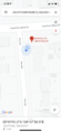
The Proof
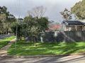
The pergola
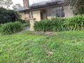
The house


Achievements
BrendanTWhite earned the Drag-along achievement
|