Difference between revisions of "2021-01-18 46 4"
From Geohashing
m (Location) |
(Coordinates reached) |
||
| Line 16: | Line 16: | ||
== Photos == | == Photos == | ||
| + | <gallery> | ||
| + | Image:2021-01-18 46 4 01.jpg | At the train station | ||
| + | Image:2021-01-18 46 4 02.jpg | At the geohash | ||
| + | Image:2021-01-18 46 4 03.png | Coordinates reached | ||
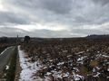
| + | Image:2021-01-18 46 4 04.jpg | View from the geohash | ||
| + | Image:2021-01-18 46 4 05.jpg | Stupid grin | ||
| + | Image:2021-01-18 46 4 06.jpg | At the chapel | ||
| + | Image:2021-01-18 46 4 07.jpg | Passing through Fleurie | ||
| + | Image:2021-01-18 46 4 08.jpg | My ride back home | ||
| + | </gallery> | ||
== Achievements == | == Achievements == | ||
{{#vardefine:ribbonwidth|800px}} | {{#vardefine:ribbonwidth|800px}} | ||
| + | {{land geohash | ||
| + | | latitude = 46 | ||
| + | | longitude = 4 | ||
| + | | date = 2021-01-18 | ||
| + | | name = [[User:Baarde|Baarde]] | ||
| + | }} | ||
__NOTOC__ | __NOTOC__ | ||
[[Category:Expeditions]] | [[Category:Expeditions]] | ||
| + | [[Category:Expeditions with photos]] | ||
| + | [[Category:Coordinates reached]] | ||
{{location|FR|69}} | {{location|FR|69}} | ||
Revision as of 19:59, 18 January 2021
| Mon 18 Jan 2021 in 46,4: 46.1856815, 4.6870272 geohashing.info google osm bing/os kml crox |
Location
In the vineyards near Fleurie.
Participants
Plans
I will take the train to Romanèche-Thorins and walk from there to the geohash. I should reach the coordinates around 15:00.
Expedition
Photos
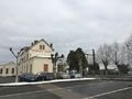
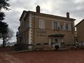
At the train station
At the geohash
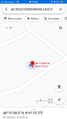
Coordinates reached
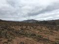
View from the geohash
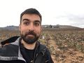
Stupid grin
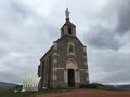
At the chapel
Passing through Fleurie
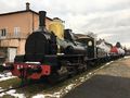
My ride back home


Achievements
Baarde earned the Land geohash achievement
|