Difference between revisions of "2021-08-10 49 6"
m (Location) |
(Photos and Expedition) |
||
| (One intermediate revision by the same user not shown) | |||
| Line 5: | Line 5: | ||
}} | }} | ||
== Location == | == Location == | ||
| − | In a cemetery, in [[wikipedia:Saarbrücken|Saarbrücken]]. | + | In a woodland cemetery, in [[wikipedia:Saarbrücken|Saarbrücken]]. |
== Participants == | == Participants == | ||
| Line 12: | Line 12: | ||
== Plans == | == Plans == | ||
I will take the train from Sélestat to Sarreguemines, then cycle across the border. I expect to reach the coordinates around 15:30. | I will take the train from Sélestat to Sarreguemines, then cycle across the border. I expect to reach the coordinates around 15:30. | ||
| + | |||
| + | == Expedition == | ||
| + | I cycled from Sarreguemines to Saarbrücken, on a bicycle road on the left bank of the Saar river. In Saarbrücken, I crossed the river and arrived to Waldfriedhof Burbach, a woodland cemetery. The section of the cemetery where the coordinates were located looked more like a forest than a cemetery. The graves were few and scattered and the paths surrounded by shrubs and brambles (with delicious blackberries). | ||
| + | |||
| + | After recording proof, I struggled to exit the city because most of the bridges in Saarbrücken are elevated highways built with regards for cyclists or pedestrians (which, for a city named ''Bridges on the Saar'', is ironic). | ||
| + | |||
| + | == Photos == | ||
| + | <gallery> | ||
| + | Image:2021-08-10 49 6 01.jpg | Cycling along the Saar | ||
| + | Image:2021-08-10 49 6 02.jpg | Crossing the France-Germany border | ||
| + | Image:2021-08-10 49 6 10.jpg | The Saar in Saarbrücken | ||
| + | Image:2021-08-10 49 6 03.jpg | At the cemetery | ||
| + | Image:2021-08-10 49 6 04.jpg | which doesn't look like a cemetery | ||
| + | Image:2021-08-10 49 6 09.jpg | Yum! | ||
| + | Image:2021-08-10 49 6 05.png | Coordinates reached | ||
| + | Image:2021-08-10 49 6 06.jpg | Stupid grin | ||
| + | Image:2021-08-10 49 6 07.jpg | Surroundings (East) | ||
| + | Image:2021-08-10 49 6 08.jpg | Surroundings (West) | ||
| + | </gallery> | ||
| + | |||
| + | == Achievements == | ||
| + | {{#vardefine:ribbonwidth|100%}} | ||
| + | {{land geohash | ||
| + | | latitude = 49 | ||
| + | | longitude = 6 | ||
| + | | date = 2021-08-10 | ||
| + | | name = [[User:Baarde|Baarde]] | ||
| + | }} | ||
| + | {{Border geohash achievement | ||
| + | | latitude = 49 | ||
| + | | longitude = 6 | ||
| + | | date = 2021-08-10 | ||
| + | | name = [[User:Baarde|Baarde]] | ||
| + | | country1 = France | ||
| + | | country2 = Germany | ||
| + | }} | ||
| + | {{Minesweeper geohash | ||
| + | | graticule = Strasbourg, France | ||
| + | | name = [[User:Baarde|Baarde]] | ||
| + | | ranknumber = 2 | ||
| + | | s = true | ||
| + | | nw = true | ||
| + | }} | ||
| + | {{Minesweeper geohash | ||
| + | | graticule = Luxembourg, Luxembourg | ||
| + | | name = [[User:Baarde|Baarde]] | ||
| + | | ranknumber = 1 | ||
| + | | se = true | ||
| + | }} | ||
__NOTOC__ | __NOTOC__ | ||
[[Category:Expeditions]] | [[Category:Expeditions]] | ||
| + | [[Category:Expeditions with photos]] | ||
| + | [[Category:Coordinates reached]] | ||
{{location|DE|SL|SB}} | {{location|DE|SL|SB}} | ||
Latest revision as of 14:22, 11 August 2021
| Tue 10 Aug 2021 in 49,6: 49.2539957, 6.9484850 geohashing.info google osm bing/os kml crox |
Location
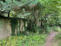
In a woodland cemetery, in Saarbrücken.
Participants
Plans
I will take the train from Sélestat to Sarreguemines, then cycle across the border. I expect to reach the coordinates around 15:30.
Expedition
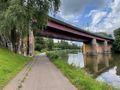
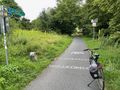
I cycled from Sarreguemines to Saarbrücken, on a bicycle road on the left bank of the Saar river. In Saarbrücken, I crossed the river and arrived to Waldfriedhof Burbach, a woodland cemetery. The section of the cemetery where the coordinates were located looked more like a forest than a cemetery. The graves were few and scattered and the paths surrounded by shrubs and brambles (with delicious blackberries).
After recording proof, I struggled to exit the city because most of the bridges in Saarbrücken are elevated highways built with regards for cyclists or pedestrians (which, for a city named Bridges on the Saar, is ironic).
Photos
Cycling along the Saar
Crossing the France-Germany border
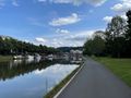
The Saar in Saarbrücken
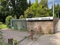
At the cemetery
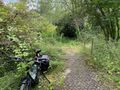
which doesn't look like a cemetery
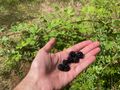
Yum!
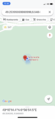
Coordinates reached
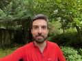
Stupid grin
Surroundings (East)
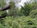
Surroundings (West)


Achievements
Baarde earned the Land geohash achievement
|
Baarde earned the Border geohash achievement
|
Baarde achieved level 2 of the Minesweeper Geohash achievement
|
Baarde achieved level 1 of the Minesweeper Geohash achievement
|