Difference between revisions of "2021-09-04 48 7"
(Create expedition report) |
(Coordinates reached) |
||
| (One intermediate revision by one other user not shown) | |||
| Line 9: | Line 9: | ||
== Participants == | == Participants == | ||
* [[User:Baarde|Baarde]] | * [[User:Baarde|Baarde]] | ||
| + | |||
| + | == Expedition == | ||
| + | My mother had suggested that I come visit her for the weekend in her home in Colroy-la-Roche, a (relatively) remote village in the Vosges mountains. Today's coordinates were conveniently located in Colroy-la-Grande, only 8 km from there and, more importantly, more or less in the same valley: the perfect opportunity to kill two birds with one stone. | ||
| + | |||
| + | I departed at 13:30 and cycled from Sélestat to Saales via the Steige Pass. Shortly after exiting Saales, I left the road and took a mountain path across the railway and around the Voyemont mountain. I abandoned my bicycle near the remains of a WW1 bunker, 20 meters below the coordinates, and hiked the between the trees up to the hashpoint. | ||
| + | |||
| + | There I waited a few minutes for the clock to mark [[Saturday meetup|16:00]]. | ||
| + | |||
| + | == Photos == | ||
| + | <gallery> | ||
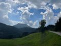
| + | File:2021-09-04 48 7 01.jpg | Nice day for a bicycle geohash | ||
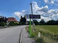
| + | File:2021-09-04 48 7 02.jpg | My first expedition in the Vosges | ||
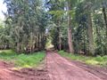
| + | File:2021-09-04 48 7 03.jpg | In the forest | ||
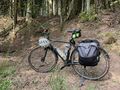
| + | File:2021-09-04 48 7 04.jpg | My bicycle near the geohash | ||
| + | File:2021-09-04 48 7 05.jpg | The geohash | ||
| + | File:2021-09-04 48 7 06.jpg | Surroundings (South) | ||
| + | File:2021-09-04 48 7 07.jpg | Surroundings (North) | ||
| + | File:2021-09-04 48 7 08.jpg | Stupid grin | ||
| + | File:2021-09-04 48 7 09.png | Coordinates reached | ||
| + | </gallery> | ||
== Achievements == | == Achievements == | ||
| Line 33: | Line 53: | ||
__NOTOC__ | __NOTOC__ | ||
[[Category:Expeditions]] | [[Category:Expeditions]] | ||
| + | [[Category:Expeditions with photos]] | ||
| + | [[Category:Coordinates reached]] | ||
| + | {{location|FR|88}} | ||
Latest revision as of 15:44, 6 September 2021
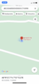
| Sat 4 Sep 2021 in 48,7: 48.3326847, 7.1209803 geohashing.info google osm bing/os kml crox |
Location
On a small mountain near Colroy-la-Grande.
Participants
Expedition
My mother had suggested that I come visit her for the weekend in her home in Colroy-la-Roche, a (relatively) remote village in the Vosges mountains. Today's coordinates were conveniently located in Colroy-la-Grande, only 8 km from there and, more importantly, more or less in the same valley: the perfect opportunity to kill two birds with one stone.
I departed at 13:30 and cycled from Sélestat to Saales via the Steige Pass. Shortly after exiting Saales, I left the road and took a mountain path across the railway and around the Voyemont mountain. I abandoned my bicycle near the remains of a WW1 bunker, 20 meters below the coordinates, and hiked the between the trees up to the hashpoint.
There I waited a few minutes for the clock to mark 16:00.
Photos
Nice day for a bicycle geohash
My first expedition in the Vosges
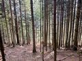
In the forest
My bicycle near the geohash
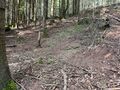
The geohash
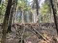
Surroundings (South)
Surroundings (North)
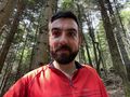
Stupid grin
Coordinates reached


Achievements
Baarde earned the Land geohash achievement
|
Baarde earned the Bicycle geohash achievement
|
Baarde earned the xkcd Nullaturion achievement
|