Difference between revisions of "2010-04-05 50 -1"
imported>Sermoa m (→Location: update the location) |
m (Removing expedition planning category) |
||
| (5 intermediate revisions by 3 users not shown) | |||
| Line 1: | Line 1: | ||
| − | |||
| − | |||
| − | |||
| − | |||
| − | |||
| − | |||
{{meetup graticule | {{meetup graticule | ||
| lat=50 | | lat=50 | ||
| Line 23: | Line 17: | ||
== Plans == | == Plans == | ||
<!-- what were the original plans --> | <!-- what were the original plans --> | ||
| − | [[User:Sermoa|Sermoa]] plans to get to this geohash somehow. it's been way too long since i went geohashing! unfortunately there seem to be engineering works between winchester and eastleigh, which means it'll be a replacement bus to eastleigh, then a train to fareham before getting a train to swanwick. after which there is a short walk to the geohash location. i shall try to be there for 4pm. | + | <strike>[[User:Sermoa|Sermoa]] plans to get to this geohash somehow. it's been way too long since i went geohashing! unfortunately there seem to be engineering works between winchester and eastleigh, which means it'll be a replacement bus to eastleigh, then a train to fareham before getting a train to swanwick. after which there is a short walk to the geohash location. i shall try to be there for 4pm. |
| − | I'm hoping i might be able to combine the expedition with [http://www.geocaching.com/seek/cache_details.aspx?guid=040fc6e7-3115-4e87-9eea-b42d561e0545 Sidetracked - Swanwick] geocache as i have a geocoin to drop off somewhere :) | + | I'm hoping i might be able to combine the expedition with [http://www.geocaching.com/seek/cache_details.aspx?guid=040fc6e7-3115-4e87-9eea-b42d561e0545 Sidetracked - Swanwick] geocache as i have a geocoin to drop off somewhere :)</strike> |
'''Cancel that!''' | '''Cancel that!''' | ||
| − | I've just had the presence of mind to check the google streetview and i find out [http://maps.google.com/maps?q=loc:50.8796674722457239981,-1.2561087985562102456(Geohash+on+2010-04-05+in+50,+-1:+Rookery+Ave,+Hampshire+PO15+7,+UK)&ie=UTF8&ll=50.880463,-1.257226&spn=0.003879,0.008862&t=rh&z=17&layer=c&cbll=50.880397,-1.257323&panoid=k8SBKrn6EXjUhwE8GGvgdA&cbp=12,135.62,,0,8.16 the geohash is in a school] | + | I've just had the presence of mind to check the google streetview and i find out [http://maps.google.com/maps?q=loc:50.8796674722457239981,-1.2561087985562102456(Geohash+on+2010-04-05+in+50,+-1:+Rookery+Ave,+Hampshire+PO15+7,+UK)&ie=UTF8&ll=50.880463,-1.257226&spn=0.003879,0.008862&t=rh&z=17&layer=c&cbll=50.880397,-1.257323&panoid=k8SBKrn6EXjUhwE8GGvgdA&cbp=12,135.62,,0,8.16 the geohash is in a school] - Whiteley Primary School in fact. which means i won't be going after all. Thank Google for UK-wide Streetview! |
| − | |||
== Expedition == | == Expedition == | ||
| Line 36: | Line 29: | ||
*Creating page from the android app -- [[User:Sermoa|sermoa]] 13:11, 03 April 2010 (GMT+01:00) | *Creating page from the android app -- [[User:Sermoa|sermoa]] 13:11, 03 April 2010 (GMT+01:00) | ||
| − | |||
| − | |||
== Photos == | == Photos == | ||
| Line 44: | Line 35: | ||
--> | --> | ||
<gallery perrow="4"> | <gallery perrow="4"> | ||
| + | Image:Whiteley-school.png | Google Streetview shows me that this is not a good place to attempt to go geohashing! | ||
</gallery> | </gallery> | ||
| − | + | [[Category:Not reached - Did not attempt]] | |
| − | + | {{location|GB|ENG|HAM}} | |
| − | |||
| − | |||
| − | |||
| − | |||
| − | |||
| − | |||
| − | |||
| − | |||
| − | |||
| − | |||
| − | |||
| − | |||
| − | |||
| − | |||
| − | |||
| − | |||
| − | |||
| − | |||
| − | |||
| − | [[Category:Not reached | ||
| − | |||
| − | |||
Latest revision as of 17:54, 6 September 2021
| Mon 5 Apr 2010 in 50,-1: 50.8796675, -1.2561088 geohashing.info google osm bing/os kml crox |
Location
Whiteley Primary School. Without privileged access, i think this would be a failed expedition from the start.
Participants
Plans
Sermoa plans to get to this geohash somehow. it's been way too long since i went geohashing! unfortunately there seem to be engineering works between winchester and eastleigh, which means it'll be a replacement bus to eastleigh, then a train to fareham before getting a train to swanwick. after which there is a short walk to the geohash location. i shall try to be there for 4pm.
I'm hoping i might be able to combine the expedition with Sidetracked - Swanwick geocache as i have a geocoin to drop off somewhere :)
Cancel that! I've just had the presence of mind to check the google streetview and i find out the geohash is in a school - Whiteley Primary School in fact. which means i won't be going after all. Thank Google for UK-wide Streetview!
Expedition
- Creating page from the android app -- sermoa 13:11, 03 April 2010 (GMT+01:00)
Photos
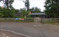
Google Streetview shows me that this is not a good place to attempt to go geohashing!
