Difference between revisions of "2010-04-05 50 -1"
imported>Sermoa m (remove the tracklog) |
m (Removing expedition planning category) |
||
| (2 intermediate revisions by 2 users not shown) | |||
| Line 1: | Line 1: | ||
| − | |||
| − | |||
| − | |||
| − | |||
| − | |||
| − | |||
{{meetup graticule | {{meetup graticule | ||
| lat=50 | | lat=50 | ||
| Line 45: | Line 39: | ||
| − | + | [[Category:Not reached - Did not attempt]] | |
| − | + | {{location|GB|ENG|HAM}} | |
| − | |||
| − | |||
| − | |||
| − | |||
| − | |||
| − | |||
| − | |||
| − | |||
| − | |||
| − | |||
| − | |||
| − | |||
| − | |||
| − | |||
| − | |||
| − | |||
| − | |||
| − | |||
| − | |||
| − | [[Category:Not reached | ||
| − | |||
| − | |||
Latest revision as of 17:54, 6 September 2021
| Mon 5 Apr 2010 in 50,-1: 50.8796675, -1.2561088 geohashing.info google osm bing/os kml crox |
Location
Whiteley Primary School. Without privileged access, i think this would be a failed expedition from the start.
Participants
Plans
Sermoa plans to get to this geohash somehow. it's been way too long since i went geohashing! unfortunately there seem to be engineering works between winchester and eastleigh, which means it'll be a replacement bus to eastleigh, then a train to fareham before getting a train to swanwick. after which there is a short walk to the geohash location. i shall try to be there for 4pm.
I'm hoping i might be able to combine the expedition with Sidetracked - Swanwick geocache as i have a geocoin to drop off somewhere :)
Cancel that! I've just had the presence of mind to check the google streetview and i find out the geohash is in a school - Whiteley Primary School in fact. which means i won't be going after all. Thank Google for UK-wide Streetview!
Expedition
- Creating page from the android app -- sermoa 13:11, 03 April 2010 (GMT+01:00)
Photos
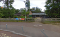
Google Streetview shows me that this is not a good place to attempt to go geohashing!
