Difference between revisions of "2010-04-28 45 -122"
imported>Aperfectring (*poof*) |
m |
||
| (16 intermediate revisions by 3 users not shown) | |||
| Line 1: | Line 1: | ||
| − | |||
<!-- If you did not specify these parameters in the template, please substitute appropriate things for IMAGE, LAT, LON, and DATE (YYYY-MM-DD format) | <!-- If you did not specify these parameters in the template, please substitute appropriate things for IMAGE, LAT, LON, and DATE (YYYY-MM-DD format) | ||
| Line 12: | Line 11: | ||
}} | }} | ||
| − | + | {{PBGH battleship | |
| + | | lat=45 | ||
| + | | lon=-122 | ||
| + | | date=2010-04-28 | ||
| + | }} | ||
__NOTOC__ | __NOTOC__ | ||
== Location == | == Location == | ||
| − | + | Near the intersection of Cornell and Barnes out on the west side. Tax maps show the properties to be zoned commercial, so "no trespassing" seems less likely than if it were residential. | |
== Participants == | == Participants == | ||
| − | + | * [[User:Aperfectring|APR]] - Likely to make the trip after work (probably at the hashpoint around 6:30 or so). | |
| + | * [[User:Jiml|Jim]] - Has grabbed the camera and batteries. | ||
== Plans == | == Plans == | ||
| − | + | I plan to go home, grab GPS unit, camera, and head out shortly after. I would prefer not to drive, as my car is shifting a bit roughly, but am more than willing to do so if needed. I may also end up trying to take the train+bike, but going down Barnes and Cornell during rush hour doesn't sound like too nice of a prospect to me, esp. if it is still rainy. --[[User:Aperfectring|aperfectring]] 15:11, 28 April 2010 (UTC) | |
== Expedition == | == Expedition == | ||
<!-- how it all turned out. your narrative goes here. --> | <!-- how it all turned out. your narrative goes here. --> | ||
| − | |||
| − | |||
| − | == | + | *The expedition is off to a great start. I walk out the door, the sun is shining in my eyes, and pea sized hailstones are hitting my head! -- [[User:Aperfectring|aperfectring]] [http://www.openstreetmap.org/?lat=45.523275&lon=-122.935947&zoom=16&layers=B000FTF @45.5233,-122.9359] 00:12, 29 April 2010 (UTC) |
| − | + | ||
| − | + | *Ooh, a rainbow, or is that a hailbow? No pic as it faded too quick. -- [[User:Aperfectring|aperfectring]] [http://www.openstreetmap.org/?lat=45.56870838333333&lon=-122.92493793333334&zoom=16&layers=B000FTF @45.5687,-122.9249] 00:20, 29 April 2010 (UTC) | |
| − | -- | + | |
| − | + | *Tax maps lied, residential not commercial, no one to ask, so no trespassing. -- [[User:Aperfectring|aperfectring]] [http://www.openstreetmap.org/?lat=45.52544331666667&lon=-122.80359088333333&zoom=16&layers=B000FTF @45.5254,-122.8036] 00:56, 29 April 2010 (UTC) | |
| − | + | ||
| + | |||
| + | == Photos == | ||
| + | <gallery> | ||
| + | Image:2010-04-28_45_-122_17-23-40-344.jpg | It a (rain|hail)bow! (Look closely at power pole) [http://www.openstreetmap.org/?lat=45.571868333333335&lon=-122.90116828333333&zoom=16&layers=B000FTF @45.5719,-122.9012] | ||
| + | Image:2010-04-28_45_-122_18-11-29-150.jpg | Deja vu! It seems like we were just here a couple months ago! [http://www.openstreetmap.org/?lat=45.55932248333333&lon=-122.91339775&zoom=16&layers=B000FTF @45.5593,-122.9134] | ||
| − | + | Image:2010-04-28_45_-122-hashpoint.jpg | A view of the inaccessible hashpoint | |
| − | + | Image:2010-04-28_45_-122-sad-APR.jpg | A sad APR | |
| − | + | Image:2010-04-28_45_-122-sad-Jim.jpg | A sad Jim | |
| − | < | + | </gallery> |
| − | |||
| − | |||
| − | |||
| − | |||
[[Category:Expeditions]] | [[Category:Expeditions]] | ||
| − | |||
| − | |||
| − | |||
| − | |||
| − | |||
| − | |||
| − | |||
| − | |||
| − | |||
| − | |||
| − | |||
[[Category:Coordinates not reached]] | [[Category:Coordinates not reached]] | ||
| − | |||
| − | |||
[[Category:Not reached - No public access]] | [[Category:Not reached - No public access]] | ||
| − | + | {{location|US|OR|WI}} | |
| − | |||
| − | |||
Latest revision as of 12:24, 12 September 2021
| Wed 28 Apr 2010 in 45,-122: 45.5255562, -122.8042341 geohashing.info google osm bing/os kml crox |
Today's battleship location is: B
6
Location
Near the intersection of Cornell and Barnes out on the west side. Tax maps show the properties to be zoned commercial, so "no trespassing" seems less likely than if it were residential.
Participants
- APR - Likely to make the trip after work (probably at the hashpoint around 6:30 or so).
- Jim - Has grabbed the camera and batteries.
Plans
I plan to go home, grab GPS unit, camera, and head out shortly after. I would prefer not to drive, as my car is shifting a bit roughly, but am more than willing to do so if needed. I may also end up trying to take the train+bike, but going down Barnes and Cornell during rush hour doesn't sound like too nice of a prospect to me, esp. if it is still rainy. --aperfectring 15:11, 28 April 2010 (UTC)
Expedition
- The expedition is off to a great start. I walk out the door, the sun is shining in my eyes, and pea sized hailstones are hitting my head! -- aperfectring @45.5233,-122.9359 00:12, 29 April 2010 (UTC)
- Ooh, a rainbow, or is that a hailbow? No pic as it faded too quick. -- aperfectring @45.5687,-122.9249 00:20, 29 April 2010 (UTC)
- Tax maps lied, residential not commercial, no one to ask, so no trespassing. -- aperfectring @45.5254,-122.8036 00:56, 29 April 2010 (UTC)
Photos
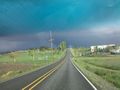
hail)bow! (Look closely at power pole) @45.5719,-122.9012
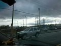
Deja vu! It seems like we were just here a couple months ago! @45.5593,-122.9134
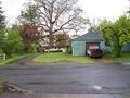
A view of the inaccessible hashpoint

A sad APR

A sad Jim


