Difference between revisions of "2017-01-29 47 11"
From Geohashing
imported>Claralucia9 (→Location) |
m (Username changed) |
||
| (5 intermediate revisions by 3 users not shown) | |||
| Line 22: | Line 22: | ||
== Participants == | == Participants == | ||
| − | + | [[User:Clearlucid9|Claralucia9]] ([[User talk:Clearlucid9|talk]]) | |
| − | |||
| − | [[User: | ||
== Plans == | == Plans == | ||
| Line 30: | Line 28: | ||
== Expedition == | == Expedition == | ||
| − | + | Been there just after sunrise! A marvelous walk through a snowy forest with bright morning light. What more can you ask for? I started following the footprints of a deer until I came within 9m to the hash point that was located in a densely grown section of the forest. Fighting my way through the branches the GPS started to shift forth and back, but I managed to get within 2m of the given coordinates. On my way back to the car I felt lucky to have risen early in the morning to go for this hash. Else I would have missed the spectacular views of the rising sun over the snow fields. | |
| − | Been there just after sunrise! A marvelous walk through a snowy | ||
== Tracklog == | == Tracklog == | ||
| Line 58: | Line 55: | ||
<!-- =============== USEFUL CATEGORIES FOLLOW ================ | <!-- =============== USEFUL CATEGORIES FOLLOW ================ | ||
| − | |||
| − | |||
| − | |||
| − | |||
| − | |||
<!-- Potential categories. Please include all the ones appropriate to your expedition --> | <!-- Potential categories. Please include all the ones appropriate to your expedition --> | ||
| − | |||
| − | |||
| − | |||
| − | |||
| − | |||
| − | |||
| − | |||
[[Category:Expeditions]] | [[Category:Expeditions]] | ||
| − | |||
[[Category:Expeditions with photos]] | [[Category:Expeditions with photos]] | ||
| − | |||
| − | |||
| − | |||
| − | |||
| − | |||
[[Category:Coordinates reached]] | [[Category:Coordinates reached]] | ||
| − | + | {{location|DE|BY|M}} | |
| − | |||
| − | |||
| − | |||
| − | |||
| − | |||
| − | |||
| − | |||
| − | |||
| − | |||
| − | |||
| − | |||
| − | |||
| − | |||
| − | |||
| − | |||
| − | |||
| − | |||
Latest revision as of 12:32, 31 October 2021
| Sun 29 Jan 2017 in 47,11: 47.9710690, 11.7476478 geohashing.info google osm bing/os kml crox |
Location
In a forest close to Aying south of Munich
Participants
Plans
Expedition
Been there just after sunrise! A marvelous walk through a snowy forest with bright morning light. What more can you ask for? I started following the footprints of a deer until I came within 9m to the hash point that was located in a densely grown section of the forest. Fighting my way through the branches the GPS started to shift forth and back, but I managed to get within 2m of the given coordinates. On my way back to the car I felt lucky to have risen early in the morning to go for this hash. Else I would have missed the spectacular views of the rising sun over the snow fields.
Tracklog
Photos

logproof
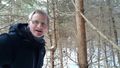
Me at the hashpoint
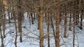
At the hash
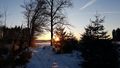
Sunrise1
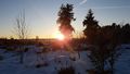
Sunrise 2


