Difference between revisions of "2017-04-23 48 11"
imported>Claralucia9 (→Location) |
m (Username changed) |
||
| (10 intermediate revisions by 3 users not shown) | |||
| Line 19: | Line 19: | ||
== Location == | == Location == | ||
| − | + | deep in a forest between Hohenbrunn and Höhenkirchen-Siegertsbrunn, southeast of Munich | |
| − | deep in a | ||
== Participants == | == Participants == | ||
| − | + | [[User:Clearlucid9|Claralucia9]] ([[User talk:Clearlucid9|talk]]) | |
| − | |||
== Plans == | == Plans == | ||
| Line 31: | Line 29: | ||
== Expedition == | == Expedition == | ||
<!-- how it all turned out. your narrative goes here. --> | <!-- how it all turned out. your narrative goes here. --> | ||
| + | I left home very early on Sunday morning to go for this Geohash because of other plans for later this day... | ||
| + | Arriving at a parking as close as possible to the hash my mobile phone told my I'd have to walk for about 1.5 km. So I headed of, trying to follow the instructions from Google Maps. But given the jumping coordinates in the forest and the limited number of footpaths on Maps it didn't take long to get lost. So I had to rely on coordinates and general orientation. Zig-zaging my way towards the hash point my shoes started to get wet as it had rained over night. The nice thing was that there were a lot of birds singing their early morning songs. | ||
| + | When I got close to the final coordinates in a very nice area of the forest the coordinates started jumping again and it took a lot of forth and back to stand as close as possible to ground zero. | ||
| + | I marked the spot with an "X" formed by two branches, took my photos and then faced the challenged to find my way back to the car. I did manage in the end and concluded my 1 h walk happy to have reached the hash point today. | ||
| + | *Reached at 7.42 am -- [[User:Clearlucid9|Claralucia9]] ([[User talk:Clearlucid9|talk]]) 07:42, 23 April 2017 (GMT+02:00) | ||
| − | |||
== Tracklog == | == Tracklog == | ||
<!-- if your GPS device keeps a log, you may post a link here --> | <!-- if your GPS device keeps a log, you may post a link here --> | ||
| Line 42: | Line 44: | ||
--> | --> | ||
<gallery perrow="5"> | <gallery perrow="5"> | ||
| + | Image:2017-04-23_07.41.34-1.jpg|Panorama from the hash | ||
| + | Image:2017-04-23_07.41.52.jpg|Me at the hash | ||
| + | Image:2017-04-23 07.45.34.jpg|"X" marks the spot | ||
| + | Image:Screenshot_20170423-074037.png|Logproof | ||
</gallery> | </gallery> | ||
| Line 48: | Line 54: | ||
<!-- Add any achievement ribbons you earned below, or remove this section --> | <!-- Add any achievement ribbons you earned below, or remove this section --> | ||
| − | |||
| − | |||
| − | |||
| − | |||
| − | |||
| − | |||
| − | |||
| − | |||
| − | |||
| − | |||
| − | |||
| − | |||
| − | |||
| − | |||
[[Category:Expeditions]] | [[Category:Expeditions]] | ||
| − | |||
[[Category:Expeditions with photos]] | [[Category:Expeditions with photos]] | ||
| − | |||
| − | |||
| − | |||
| − | |||
| − | |||
[[Category:Coordinates reached]] | [[Category:Coordinates reached]] | ||
| − | + | {{location|DE|BY|M}} | |
| − | |||
| − | |||
| − | |||
| − | |||
| − | |||
| − | |||
| − | |||
| − | |||
| − | |||
| − | |||
| − | |||
| − | |||
| − | |||
| − | |||
| − | |||
| − | |||
| − | |||
Latest revision as of 12:32, 31 October 2021
| Sun 23 Apr 2017 in 48,11: 48.0530963, 11.7363046 geohashing.info google osm bing/os kml crox |
Location
deep in a forest between Hohenbrunn and Höhenkirchen-Siegertsbrunn, southeast of Munich
Participants
Plans
Expedition
I left home very early on Sunday morning to go for this Geohash because of other plans for later this day... Arriving at a parking as close as possible to the hash my mobile phone told my I'd have to walk for about 1.5 km. So I headed of, trying to follow the instructions from Google Maps. But given the jumping coordinates in the forest and the limited number of footpaths on Maps it didn't take long to get lost. So I had to rely on coordinates and general orientation. Zig-zaging my way towards the hash point my shoes started to get wet as it had rained over night. The nice thing was that there were a lot of birds singing their early morning songs. When I got close to the final coordinates in a very nice area of the forest the coordinates started jumping again and it took a lot of forth and back to stand as close as possible to ground zero. I marked the spot with an "X" formed by two branches, took my photos and then faced the challenged to find my way back to the car. I did manage in the end and concluded my 1 h walk happy to have reached the hash point today.
- Reached at 7.42 am -- Claralucia9 (talk) 07:42, 23 April 2017 (GMT+02:00)
Tracklog
Photos
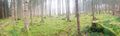
Panorama from the hash
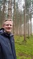
Me at the hash
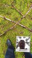
"X" marks the spot
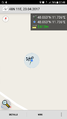
Logproof


