Difference between revisions of "2017-04-29 47 11"
imported>Claralucia9 (→Participants) |
m (Username changed) |
||
| (6 intermediate revisions by 3 users not shown) | |||
| Line 22: | Line 22: | ||
== Participants == | == Participants == | ||
| − | Claralucia9 | + | [[User:Clearlucid9|Claralucia9]] ([[User talk:Clearlucid9|talk]]) |
== Plans == | == Plans == | ||
| Line 28: | Line 28: | ||
== Expedition == | == Expedition == | ||
| − | + | Another geohash that's not too far from home - just right for an early Saturday morning excursion I thought. On my way there by car I had to realize that the motorway exit of Holzkirchen was closed due to construction so I had to take the next exit and return. Anyway - I stopped to pick up a TB at a geocache and then headed for the hash. I had to follow a very narrow road and was lucky not to encounter any traffic in the opposite direction. Beautiful views of the rising sun over a foggy snowfield. As if the hash hat been chosen by purpose :-) | |
| + | I got within less then a meter from the given coordinated, marked it with a "X" in the snow, took my pictures (7:53 am) and then headed back for a family breakfast. | ||
| − | |||
| − | |||
== Tracklog == | == Tracklog == | ||
<!-- if your GPS device keeps a log, you may post a link here --> | <!-- if your GPS device keeps a log, you may post a link here --> | ||
== Photos == | == Photos == | ||
| − | |||
| − | |||
| − | |||
<gallery perrow="5"> | <gallery perrow="5"> | ||
| + | Image:2017-04-29 07.57.37.jpg|hash location | ||
| + | Image:2017-04-29 07.54.01-2.jpg|panorama from the hash | ||
| + | Image:2017-04-29 07.53.21.jpg|me at the cache | ||
| + | Image:2017-04-29 07.50.49.jpg|road to the hash | ||
| + | Image:2017-04-29 07.48.41.jpg|sunrise over fog | ||
| + | Image:2017-04-29 05.56.27.png|Logproof | ||
</gallery> | </gallery> | ||
| Line 46: | Line 48: | ||
<!-- Add any achievement ribbons you earned below, or remove this section --> | <!-- Add any achievement ribbons you earned below, or remove this section --> | ||
| − | |||
| − | |||
| − | |||
| − | |||
| − | |||
| − | |||
| − | |||
| − | |||
| − | |||
| − | |||
| − | |||
| − | |||
| − | |||
| − | |||
[[Category:Expeditions]] | [[Category:Expeditions]] | ||
| − | |||
[[Category:Expeditions with photos]] | [[Category:Expeditions with photos]] | ||
| − | |||
| − | |||
| − | |||
| − | |||
| − | |||
[[Category:Coordinates reached]] | [[Category:Coordinates reached]] | ||
| − | + | {{location|DE|BY|MB}} | |
| − | |||
| − | |||
| − | |||
| − | |||
| − | |||
| − | |||
| − | |||
| − | |||
| − | |||
| − | |||
| − | |||
| − | |||
| − | |||
| − | |||
| − | |||
| − | |||
| − | |||
Latest revision as of 12:33, 31 October 2021
| Sat 29 Apr 2017 in 47,11: 47.8447441, 11.6541750 geohashing.info google osm bing/os kml crox |
Location
Close to the roadside just outside of Kleinhatpenning, south of Munich
Participants
Plans
Expedition
Another geohash that's not too far from home - just right for an early Saturday morning excursion I thought. On my way there by car I had to realize that the motorway exit of Holzkirchen was closed due to construction so I had to take the next exit and return. Anyway - I stopped to pick up a TB at a geocache and then headed for the hash. I had to follow a very narrow road and was lucky not to encounter any traffic in the opposite direction. Beautiful views of the rising sun over a foggy snowfield. As if the hash hat been chosen by purpose :-) I got within less then a meter from the given coordinated, marked it with a "X" in the snow, took my pictures (7:53 am) and then headed back for a family breakfast.
Tracklog
Photos
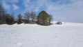
hash location
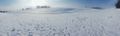
panorama from the hash
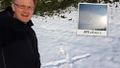
me at the cache
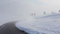
road to the hash
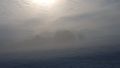
sunrise over fog
Logproof


