Difference between revisions of "2017-12-17 48 11"
From Geohashing
imported>Claralucia9 ([live picture]X marks the spot) |
m (Username changed) |
||
| (9 intermediate revisions by 4 users not shown) | |||
| Line 22: | Line 22: | ||
== Participants == | == Participants == | ||
| − | + | [[User:Clearlucid9|Claralucia9]] ([[User talk:Clearlucid9|talk]]) | |
| − | |||
== Plans == | == Plans == | ||
| Line 30: | Line 29: | ||
== Expedition == | == Expedition == | ||
<!-- how it all turned out. your narrative goes here. --> | <!-- how it all turned out. your narrative goes here. --> | ||
| + | I had planed to go to this Geohash today, but owernight snow took me by surprise a bit. But hey - that won't stop me in my expedition. So I drove slowly along the icy roads until I got reasonable close. Parking the car at a forest road, leading into the woods I set path with just a flashlight (just before dusk) and my GPS (well: actually my mobile phone...). With all the trees covered in snow the GPS didn't really want to settle on the precise coordinates so it took me quite a bit of moving forth and back till the app and I were satisfied. Screenshot, photos, marking the spot and back to the car to go and find an Opencache nearby... | ||
| + | *Reached at 7.25 am -- [[User:Clearlucid9|Claralucia9]] ([[User talk:Clearlucid9|talk]]) 07:36, 17 December 2017 (GMT+01:00) | ||
| − | |||
== Tracklog == | == Tracklog == | ||
<!-- if your GPS device keeps a log, you may post a link here --> | <!-- if your GPS device keeps a log, you may post a link here --> | ||
| Line 42: | Line 42: | ||
<gallery perrow="5"> | <gallery perrow="5"> | ||
| − | Image:2017-12-17_48_11_Claralucia9_1513492613109.jpg| | + | Image:2017-12-17_48_11_Claralucia9_1513492613109.jpg|Me at the hashpoint |
Image:2017-12-17_48_11_Claralucia9_1513492641460.jpg|Logproof | Image:2017-12-17_48_11_Claralucia9_1513492641460.jpg|Logproof | ||
Image:2017-12-17_48_11_Claralucia9_1513492680687.jpg|X marks the spot | Image:2017-12-17_48_11_Claralucia9_1513492680687.jpg|X marks the spot | ||
| + | |||
| + | Image:2017-12-17_48_11_Claralucia9_1513509672032.jpg|The woods at dusk | ||
</gallery> | </gallery> | ||
| Line 53: | Line 55: | ||
<!-- Add any achievement ribbons you earned below, or remove this section --> | <!-- Add any achievement ribbons you earned below, or remove this section --> | ||
| − | <!-- =============== USEFUL CATEGORIES FOLLOW ================ | + | <!-- =============== USEFUL CATEGORIES FOLLOW ================ --> |
| − | |||
| − | |||
| − | |||
| − | |||
| − | |||
| − | |||
| − | |||
| − | |||
| − | |||
| − | |||
| − | |||
| − | |||
| − | |||
[[Category:Expeditions]] | [[Category:Expeditions]] | ||
| − | |||
[[Category:Expeditions with photos]] | [[Category:Expeditions with photos]] | ||
| − | |||
| − | |||
| − | |||
| − | |||
| − | |||
[[Category:Coordinates reached]] | [[Category:Coordinates reached]] | ||
| − | + | {{location|DE|BY|EBE}} | |
| − | |||
| − | |||
| − | |||
| − | |||
| − | |||
| − | |||
| − | |||
| − | |||
| − | |||
| − | |||
| − | |||
| − | |||
| − | |||
| − | |||
| − | |||
| − | |||
| − | |||
Latest revision as of 12:35, 31 October 2021
| Sun 17 Dec 2017 in 48,11: 48.0008385, 11.8250286 geohashing.info google osm bing/os kml crox |
Location
Participants
Plans
Expedition
I had planed to go to this Geohash today, but owernight snow took me by surprise a bit. But hey - that won't stop me in my expedition. So I drove slowly along the icy roads until I got reasonable close. Parking the car at a forest road, leading into the woods I set path with just a flashlight (just before dusk) and my GPS (well: actually my mobile phone...). With all the trees covered in snow the GPS didn't really want to settle on the precise coordinates so it took me quite a bit of moving forth and back till the app and I were satisfied. Screenshot, photos, marking the spot and back to the car to go and find an Opencache nearby...
- Reached at 7.25 am -- Claralucia9 (talk) 07:36, 17 December 2017 (GMT+01:00)
Tracklog
Photos
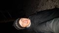
Me at the hashpoint

Logproof
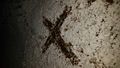
X marks the spot
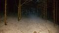
The woods at dusk


