Difference between revisions of "2017-12-30 47 11"
imported>Claralucia9 (→Photos) |
m (Username changed) |
||
| (12 intermediate revisions by 3 users not shown) | |||
| Line 19: | Line 19: | ||
== Location == | == Location == | ||
| − | + | on a hill between Dietramszell and Geretsried, south of Munich | |
== Participants == | == Participants == | ||
| − | + | [[User:Clearlucid9|Claralucia9]] ([[User talk:Clearlucid9|talk]]) | |
| − | |||
== Plans == | == Plans == | ||
| Line 29: | Line 28: | ||
== Expedition == | == Expedition == | ||
| − | + | Yeah - one more hash "close" to home before the end of the year! | |
| + | I left home early in the morning when it was still dark outside. The closer I got the smaller the roads and the more snow and ice on the road I encountered. | ||
| + | Parking wasn't easy with all dirt roads blocked by snow, so I had to improvise and park in a small lay-by that had been cleared of the snow. Luckily I had put on my winter boots so that I had no major difficulty making my way through the deep snow. After a view minutes of walking I got within less than one meter to the coordinates. Pictures taken, I went back to the car and went on to find some geocaches in the area. | ||
| + | Reached at 8:04 -- [[User:Clearlucid9|Claralucia9]] ([[User talk:Clearlucid9|talk]]) [http://www.openstreetmap.org/?lat=47.86088740&lon=11.54371690&zoom=16&layers=B000FTF @47.8609,11.5437] 08:04, 30 December 2017 (GMT+01:00) | ||
| − | |||
== Tracklog == | == Tracklog == | ||
<!-- if your GPS device keeps a log, you may post a link here --> | <!-- if your GPS device keeps a log, you may post a link here --> | ||
| Line 52: | Line 53: | ||
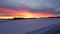
Image:2017-12-30_47_11_Claralucia9_1514617754015.jpg|Panorama | Image:2017-12-30_47_11_Claralucia9_1514617754015.jpg|Panorama | ||
| − | Image:2017-12-30_47_11_Claralucia9_1514618338951.jpg| | + | Image:2017-12-30_47_11_Claralucia9_1514618338951.jpg|Through the snow... |
| − | Image:Frosen_hash.jpeg| | + | Image:Frosen_hash.jpeg|frozen hash |
| Line 59: | Line 60: | ||
== Achievements == | == Achievements == | ||
| − | |||
| − | |||
| − | |||
| − | |||
| − | |||
| − | |||
| − | |||
| − | |||
| − | |||
| − | |||
| − | |||
| − | |||
| − | |||
| − | + | {{Frozen Geohash | |
| + | | latitude = 47 | ||
| + | | longitude = 11 | ||
| + | | date = 2017-12-30 | ||
| + | | temperature = -1°C | ||
| + | | name = claralucia9 | ||
| + | | image = Frosen_hash.jpeg | ||
| + | }} | ||
| − | |||
[[Category:Expeditions]] | [[Category:Expeditions]] | ||
| − | |||
[[Category:Expeditions with photos]] | [[Category:Expeditions with photos]] | ||
| − | |||
| − | |||
| − | |||
| − | |||
| − | |||
[[Category:Coordinates reached]] | [[Category:Coordinates reached]] | ||
| − | + | {{location|DE|BY|TÖL}} | |
| − | |||
| − | |||
| − | |||
| − | |||
| − | |||
| − | |||
| − | |||
| − | |||
| − | |||
| − | |||
| − | |||
| − | |||
| − | |||
| − | |||
| − | |||
| − | |||
| − | |||
Latest revision as of 12:35, 31 October 2021
| Sat 30 Dec 2017 in 47,11: 47.8608989, 11.5437437 geohashing.info google osm bing/os kml crox |
Location
on a hill between Dietramszell and Geretsried, south of Munich
Participants
Plans
Expedition
Yeah - one more hash "close" to home before the end of the year! I left home early in the morning when it was still dark outside. The closer I got the smaller the roads and the more snow and ice on the road I encountered. Parking wasn't easy with all dirt roads blocked by snow, so I had to improvise and park in a small lay-by that had been cleared of the snow. Luckily I had put on my winter boots so that I had no major difficulty making my way through the deep snow. After a view minutes of walking I got within less than one meter to the coordinates. Pictures taken, I went back to the car and went on to find some geocaches in the area.
Reached at 8:04 -- Claralucia9 (talk) @47.8609,11.5437 08:04, 30 December 2017 (GMT+01:00)
Tracklog
Photos
Logproof
Aproaching the hash

X marks the spot
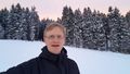
Me at today's geohash

Panorama
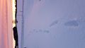
Through the snow...
frozen hash


Achievements
claralucia9 earned the Frozen Geohash Achievement
|