Difference between revisions of "2021-10-23 -38 146"
From Geohashing
m (Location) |
|||
| Line 56: | Line 56: | ||
[[Category:Expeditions with photos]] | [[Category:Expeditions with photos]] | ||
[[Category:Coordinates reached]] | [[Category:Coordinates reached]] | ||
| + | {{location|AU|VIC|LA}} | ||
Latest revision as of 19:42, 14 November 2021
| Sat 23 Oct 2021 in -38,146: -38.2063380, 146.2300434 geohashing.info google osm bing/os kml crox |
Location
By a creek in a pine forest.
Participants
Plans
Expedition
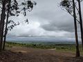
Thought this one would be better with my mountain bike. I was not wrong. Rain had eased, but the mud remained, necessitating several stints of hike-a-bike even with my mountain bike.
I was fearing a bit of troublesome bush-bashing to get to the hash, which was several metres off the path, but luckily the bush had thinned out enough that it was a simple matter to scramble down the embankment and find the coordinates.
Tracklog
Photos

At the hash
Proof!
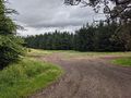
Pine forest
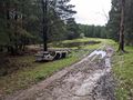
Car graveyard
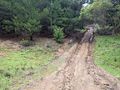
Mud mud mud
Emerging to the cleared area


