Difference between revisions of "2008-07-12 55 13"
From Geohashing
(First attempt at 080712 55 13) |
imported>FippeBot m (Location) |
||
| (2 intermediate revisions by 2 users not shown) | |||
| Line 12: | Line 12: | ||
GPS: (55.612896°, 13.260491°) | GPS: (55.612896°, 13.260491°) | ||
| + | |||
| + | == Photos == | ||
| + | <gallery caption="Photo Gallery" widths="200px" heights="200px" perrow="2"> | ||
| + | Image:20080712_55_13_01.jpg|The spot, just in front of those trees. | ||
| + | Image:20080712_55_13_02.jpg|Wheat field just beside the spot. | ||
| + | </gallery> | ||
| + | |||
| + | [[Category:Expeditions]] | ||
| + | [[Category:Expeditions with photos]] | ||
| + | [[Category:Coordinates reached]] | ||
| + | {{location|SE|M}} | ||
Latest revision as of 05:53, 7 August 2019
| Sat 12 Jul 2008 in 55,13: 55.6128965, 13.2604917 geohashing.info google osm bing/os kml crox |
About
This hash in the Malmö, Sweden graticule was located 200m off road 108 a couple of clicks south of Staffanstorp. It's categorized the vegetation as "forrest", even though it was just 20 trees in a meadow.
HannesL and David went there at 1600 hours. Didn't see any other Geohashers, even though there was a German car that stopped at the information parking just 500 meters away.
GPS: (55.612896°, 13.260491°)
Photos
- Photo Gallery
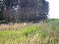
The spot, just in front of those trees.
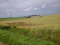
Wheat field just beside the spot.

