Difference between revisions of "2019-07-17 54 13"
imported>SastRe.O (Created page with "{{meetup graticule | lat=54 | lon=13 | date=2019-07-17 | graticule_name = Greifswald, Germany | graticule_link=54,13 }} == Location == In between fields south of...") |
m (User categories) |
||
| Line 1: | Line 1: | ||
| + | __NOTOC__ | ||
{{meetup graticule | {{meetup graticule | ||
| lat=54 | | lat=54 | ||
| Line 60: | Line 61: | ||
{{Location|DE|MV|VG}} | {{Location|DE|MV|VG}} | ||
| + | {{user categories|user=SastRe.O|bike=53.9}} | ||
[[Category:Expeditions]] | [[Category:Expeditions]] | ||
[[Category:Expeditions with photos]] | [[Category:Expeditions with photos]] | ||
[[Category:Coordinates reached]] | [[Category:Coordinates reached]] | ||
Latest revision as of 13:00, 2 March 2022
| Wed 17 Jul 2019 in Greifswald, Germany: 54.0882427, 13.7119193 geohashing.info google osm bing/os kml crox |
Location
In between fields south of Rubenow, MV, Germany.
Participants
Plans
I was not quite sure if I would have time to do this one. Eventually my schedule cleared and went for this hash. Go somewhen in the late morning, and try to reach it in 2 hours. Then come back. If in the mood, find a few caches on the way back.
Expedition
As I said, I wasn't quite sure I would have time today for this hash. It is not exactly close, but it has more or less direct and fast paths towards it. I calculated that in maybe two hours I could reach it. And today it is not so warm (21ºC), and not really windy, so good weather to ride my bike.
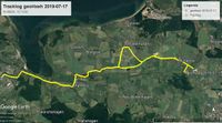
Well, I ended up having free time today, so I went after it. I grabbed Winterbuche at... 13:00, and brought some lunch with me (this may be a solid proof that I am not really German but south-european since I hadn't had lunch, yet, at 13 ;) ). The first part until Kemnitz is very well known. I take this path many many times, but right after Kemnitz, in Neuendorf, I took some new roads, turning east. Here I passed by some little settlements, Stiltow, Gustbein, Pritzwald and reaching Rubenow. Actually, in Gustbein I took the wrong road (well, not the one I had in mind) and it can bee seen in the Tracklog how I pass by Wusterhusen. Luckily I corrected it fast enough ¿^^.
In Rubenow I found some confusing signs (Hauptstraße pointing everywhere), but taking the main road was what I needed. And suddenly turn left (south). Here I was in between fields and luckily enough this path leaded me directly towards the hash. It fell in the middle of some hay bale storage area. It took 1:30, better as planed :) And here I had finally something to eat. It is probably the lamest picnic you can imagine, see picture, but that is all I gathered quickly at home. I also didn't to bring too much weight. The bag makes me sweat enough as it is...
After that I still had energy for some caches (well, I had to have energy to ride back home). First I went by a funny location. A Cow-Milk-Filling Station. Like a Gas Station but instead of Gas, you buy Milk. Directly from the... cow farm. You can't get it more pure ;)
After that, I went to search for a last cache, and took the same path home. Well, the path I planned, correcting the error I made going here. I loaded some podcasts on my phone and heard them while I approached Kemnitz and Greifswald again, reaching home at... 17h. Nice expedition.
Tracklog
Photos
Achievements
SastRe.O earned the Land geohash achievement
|
SastRe.O with Winterbuche earned the Bicycle geohash achievement
|
SastRe.O earned the Picnic achievement
|
Other Geohashing Expeditions and Plans on This Day
Expeditions and Plans
| 2019-07-17 | ||
|---|---|---|
| Casa Grande, Arizona | Wulfram | In the desert near Marana. |
| Pforzheim, Germany | RecentlyChanged | In a forest near Aldingen. |
| Frankfurt am Main, Germany | GeorgDerReisende | The hash lay under a tree in something round in a children's playground at ... |
| Dresden, Germany | Danatar | in the backyard of a building in Dresden-Trachau. Country: Germany; state:... |
| Stralsund, Germany | SastRe.O | In between fields south of Rubenow, MV, Germany. |


