Difference between revisions of "2010-05-22 42 -85"
imported>Retupmoca (Created page with '{{meetup graticule | lat=42 | lon=-85 | date=2010-05-22 | graticule_name=Grand Rapids | graticule_link=Grand Rapids, Michigan }} __NOTOC__ == Location == On the bittersweet ski …') |
m |
||
| (3 intermediate revisions by 2 users not shown) | |||
| Line 12: | Line 12: | ||
== Participants == | == Participants == | ||
| − | retupmoca and fellow adventurer. | + | [[User:Retupmoca|retupmoca]] and fellow adventurer. |
== Plans == | == Plans == | ||
| Line 21: | Line 21: | ||
== Photos == | == Photos == | ||
| − | + | <gallery perrow="4"> | |
| + | Image:2010-04-22_42_-85_GOTO.JPG|GPS set to goto. | ||
| + | Image:2010-04-22_42_-85_WAYPOINT.JPG|GPS showing current location | ||
| + | Image:2010-04-22_42_-85_smiling.JPG|Us at the hash | ||
| + | Image:2010-04-22_42_-85_hill_back.JPG|Hash location from the top of the hill | ||
| + | Image:2010-04-22_42_-85_hill_front.JPG|ski side of the hill | ||
| + | Image:2010-04-22_42_-85_party.JPG|Festivities at the bottom of the hill | ||
| + | </gallery> | ||
===Achievements Unlocked!=== | ===Achievements Unlocked!=== | ||
| Line 48: | Line 55: | ||
[[Category:Expeditions]] | [[Category:Expeditions]] | ||
[[Category:Coordinates reached]] | [[Category:Coordinates reached]] | ||
| + | {{location|US|MI|AL}} | ||
Latest revision as of 19:30, 18 March 2022
| Sat 22 May 2010 in Grand Rapids: 42.4635260, -85.7646015 geohashing.info google osm bing/os kml crox |
Location
On the bittersweet ski hill.
Participants
retupmoca and fellow adventurer.
Plans
Get on the motorcycle, ride to bittersweet, and take a picture from the gate unless it just happened to be open.
Expedition
After getting somewhat confused and riding down a road that made a turn every mile or so, I made it to the bittersweet main gate - which was open! As it turns out, there was a free, open to the public event going on (Apparently called Harry Fest: [[1]]). In any case, we received permission to climb the hill, so up we went. We ended up climbing all the way to the top of the hill while following the all-knowing GPS arrow - and then the arrow pointed over the edge, so we went partway down the side of the hill (where I started complaining about having just climbed *up* the hill), and got to the hash on fairly level ground. Mission accomplished!
Photos
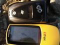
GPS set to goto.
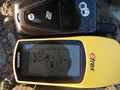
GPS showing current location
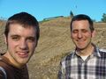
Us at the hash
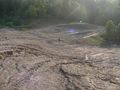
Hash location from the top of the hill
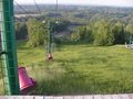
ski side of the hill
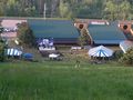
Festivities at the bottom of the hill


Achievements Unlocked!
retupmoca earned the Land geohash achievement
|
retupmoca earned the Drag-along achievement
|
retupmoca earned the 2010 Mouse Over Day achievement
|