Difference between revisions of "2009-07-29 42 -83"
imported>Billsquared |
m |
||
| (4 intermediate revisions by 4 users not shown) | |||
| Line 7: | Line 7: | ||
== About == | == About == | ||
| − | Today's hash location | + | Today's hash location appears to be right on the divider between Troy Athens HS and St. Petka Serbian Orthodox Church in Troy. |
| + | |||
| + | == Plan == | ||
| + | |||
| + | '''[[User:Billsquared|Bill^2]]:''' I'm going for the gusto this evening. The list of achievements I hope to attach to this expedition: | ||
| + | * Bicycle Geohash (will be riding from my house ~4mi NW of hash location) | ||
| + | * Drag-Along Geohash (will be literally towing my son behind in the Burley) | ||
| + | * Holy hash achievement (hash is on the grounds of the aforementioned church) | ||
| + | * Tron achievement (will document via handlebar-mounted camera on 6-second interval shooting, Google Pedometer map to be posted. | ||
| + | |||
| + | We'll plan to be there around 6:30pm. Hope to see others as well! | ||
== Expedition == | == Expedition == | ||
| − | Bill and son Brayden left home | + | Success! |
| + | |||
| + | Bill and son Brayden left home by bicycle at 6:30. After traversing sidewalks south and then east, we arrived at the hash location, which turned out to be just inside a walled-off gully between Troy Athens High School and St. Petka Serbian Orthodox Church. After locating as close as we could to the hash location, we got pictures of us with the church in the background, a picture of the high school beyond the wall, and our conveyance. | ||
| + | |||
| + | Continuing on the road we arrived on, we made our way back north and west (bypassing a possible Geosquishy Achievement on the way at a 7-Eleven a mile north of the hash location), through neighborhoods and to a local grocery. Supplies in hand (and eventually in the back of the Burley), we returned home. Map of our [http://www.mapmyride.com/route/us/mi/troy/157124891648966151 path] can be found at MapMyRide.com for validation of Tron achievement. | ||
| + | |||
| + | I also used [http://chdk.wikia.com/wiki/CHDK CHDK] and the Ultra Intervalometer to shoot one image every 5 seconds during our expedition. Stop-motion video is now [http://www.youtube.com/watch?v=zEcFy2X715k posted] to YouTube. | ||
| + | |||
| + | Video annotation for Tron Achievement: | ||
| + | |||
| + | 0:00: Lesdale Dr. | ||
| + | |||
| + | 0:02: Donaldson Dr. | ||
| + | |||
| + | 0:05: Ottawa St. | ||
| + | |||
| + | 0:09: Rochester Rd. | ||
| + | |||
| + | 0:27: Wattles Rd. | ||
| + | |||
| + | 0:33: Adams School Dr. | ||
| + | |||
| + | 0:38: Hash Location! (A bit of noodling around to find the closest spot to park.) | ||
| + | |||
| + | 0:39: Back on Adams School Dr. | ||
| + | |||
| + | 0:42: John R Rd. | ||
| + | |||
| + | 1:02: Lyster Ln. | ||
| + | |||
| + | 1:04: Northpoint Dr. | ||
| + | |||
| + | 1:08: (Connecting foot/bike path) | ||
| + | |||
| + | 1:10: Hollins Hall Ln. | ||
| + | |||
| + | 1:11: Alameda Blvd. | ||
| + | |||
| + | 1:12: Rochester Rd. | ||
| + | |||
| + | 1:16: Nino Salvaggio parking lot | ||
| + | |||
| + | 1:19: South Blvd. | ||
| + | |||
| + | 1:22: Norton Dr. | ||
| + | |||
| + | 1:24: Lovell Dr. | ||
| − | + | 1:25: Lesdale Dr. | |
== Pictures == | == Pictures == | ||
<gallery> | <gallery> | ||
| − | Image: | + | Image:2009-07-29_42_-83_gps.jpg | GPS fix as close as I could get to the hash location |
| − | Image: | + | Image:2009-07-29_42_-83_billbraydenchurch.jpg | Our stupidly grinning faces with the church in the background |
| − | Image: | + | Image:2009-07-29_42_-83_wallschool.jpg | Wall separating the church grounds from the school grounds. |
| + | Image:2009-07-29_42_-83_braydenburley.jpg | Brayden in his Burley | ||
</gallery> | </gallery> | ||
| − | {{ | + | {{holy hash | latitude = 42 | longitude = -83 | date = 2009-07-29 | name = Billsquared and Brayden | description = In front of St. Petka Serbian Orthodox Church | image = 2009-07-29_42_-83_billbraydenchurch.jpg }} |
| + | {{Bicycle geohash | latitude = 42 | longitude = -83 | date = 2009-07-29 | name = Billsquared | distance = 10.3mi | image = 2009-07-29_42_-83_braydenburley.jpg }} | ||
| + | {{Tron | ||
| − | | latitude = 42 | + | | latitude = 42 |
| − | | longitude = -83 | + | | longitude = -83 |
| − | | date = 2009- | + | | date = 2009-07-29 |
| − | | | + | | tracklog = http://www.mapmyride.com/route/us/mi/troy/157124891648966151 |
| − | | | + | | possessive = his |
| − | | | + | | name = Billsquared |
}} | }} | ||
| + | {{drag-along | ||
| + | | latitude = 42 | ||
| + | | longitude = -83 | ||
| + | | date = 2009-07-29 | ||
| + | | partner = Brayden | ||
| + | | name = Billsquared | ||
| + | | image = 2009-07-29_42_-83_braydenburley.jpg | ||
| + | }} | ||
| − | [[Category: Meetup on 2009- | + | [[Category: Expeditions]] |
| + | [[Category: Meetup on 2009-07-29]] | ||
[[Category: Meetup in 42 -83]] | [[Category: Meetup in 42 -83]] | ||
| + | [[Category:Expeditions with photos]] | ||
| + | [[Category:Coordinates reached]] | ||
| + | {{location|US|MI|OD}} | ||
Latest revision as of 23:04, 18 March 2022
| Wed 29 Jul 2009 in 42,-83: 42.5804344, -83.1123241 geohashing.info google osm bing/os kml crox |
Contents
About
Today's hash location appears to be right on the divider between Troy Athens HS and St. Petka Serbian Orthodox Church in Troy.
Plan
Bill^2: I'm going for the gusto this evening. The list of achievements I hope to attach to this expedition:
- Bicycle Geohash (will be riding from my house ~4mi NW of hash location)
- Drag-Along Geohash (will be literally towing my son behind in the Burley)
- Holy hash achievement (hash is on the grounds of the aforementioned church)
- Tron achievement (will document via handlebar-mounted camera on 6-second interval shooting, Google Pedometer map to be posted.
We'll plan to be there around 6:30pm. Hope to see others as well!
Expedition
Success!
Bill and son Brayden left home by bicycle at 6:30. After traversing sidewalks south and then east, we arrived at the hash location, which turned out to be just inside a walled-off gully between Troy Athens High School and St. Petka Serbian Orthodox Church. After locating as close as we could to the hash location, we got pictures of us with the church in the background, a picture of the high school beyond the wall, and our conveyance.
Continuing on the road we arrived on, we made our way back north and west (bypassing a possible Geosquishy Achievement on the way at a 7-Eleven a mile north of the hash location), through neighborhoods and to a local grocery. Supplies in hand (and eventually in the back of the Burley), we returned home. Map of our path can be found at MapMyRide.com for validation of Tron achievement.
I also used CHDK and the Ultra Intervalometer to shoot one image every 5 seconds during our expedition. Stop-motion video is now posted to YouTube.
Video annotation for Tron Achievement:
0:00: Lesdale Dr.
0:02: Donaldson Dr.
0:05: Ottawa St.
0:09: Rochester Rd.
0:27: Wattles Rd.
0:33: Adams School Dr.
0:38: Hash Location! (A bit of noodling around to find the closest spot to park.)
0:39: Back on Adams School Dr.
0:42: John R Rd.
1:02: Lyster Ln.
1:04: Northpoint Dr.
1:08: (Connecting foot/bike path)
1:10: Hollins Hall Ln.
1:11: Alameda Blvd.
1:12: Rochester Rd.
1:16: Nino Salvaggio parking lot
1:19: South Blvd.
1:22: Norton Dr.
1:24: Lovell Dr.
1:25: Lesdale Dr.
Pictures
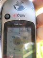
GPS fix as close as I could get to the hash location
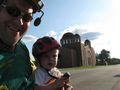
Our stupidly grinning faces with the church in the background
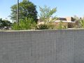
Wall separating the church grounds from the school grounds.
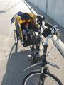
Brayden in his Burley


Billsquared and Brayden earned the Holy hash achievement
|
Billsquared earned the Bicycle geohash achievement
|
Billsquared earned the Tron achievement
|
Billsquared earned the Drag-along achievement
|