Difference between revisions of "2008-08-02 45 -122"
From Geohashing
imported>Jhon (New page: {{meetup graticule | map=<map lat="45" lon="-122" date="2008-08-02" /> | lat=45 | lon=-122 | date=2008-08-02 }} <gallery perrow="4"> Image:2008-08-02_45_-122_theLocation.jpg|The location i...) |
m |
||
| (3 intermediate revisions by 3 users not shown) | |||
| Line 5: | Line 5: | ||
| date=2008-08-02 | | date=2008-08-02 | ||
}} | }} | ||
| + | =Planning= | ||
| + | |||
| + | ((Local information taken from the e-mail list, so credit goes to [[User:Wil|Wil]] for this.)) | ||
| + | |||
| + | The location is [http://maps.google.com/maps?f=q&hl=en&geocode=18108259276590435138,45.233042,-122.877019&q=45.233043++-122.877020&ie=UTF8&t=p&z=15&iwloc=addr Here] for those that want to Google Map it. As stated by Wil, it actually has a street view. Odd. Looks to be a field right off of I-5. | ||
| + | |||
| + | Locally, it is a mile away from [http://www.oregonstateparks.org/park_113.php Champoeg State Park] and the nearest town is Woodburn. | ||
| + | |||
| + | [[User:Maravi|Maravi]] will be there, and this will be his virgin Geohash. Yay! | ||
| + | |||
| + | [[User:MrBeatdown|Tim Ferrell]] is gonna make it. 1st timer. | ||
| + | |||
| + | [[User:Maggie|Maggie]]: I will probably be there with a friend. It sort of depends on what ends up happening for the rest of the day. | ||
| + | =Participants= | ||
| + | *[[User:Wil|Wil]] | ||
| + | *[[User:Maravi|Maravi]] | ||
| + | *[[User:MrBeatdown|Tim Ferrell]] | ||
| + | *[[User:Maggie|Maggie]] | ||
| + | *[[User:Jhon|Jhon]] | ||
| + | |||
| + | =Pictures= | ||
<gallery perrow="4"> | <gallery perrow="4"> | ||
Image:2008-08-02_45_-122_theLocation.jpg|The location is about 80 feet... that way! | Image:2008-08-02_45_-122_theLocation.jpg|The location is about 80 feet... that way! | ||
| Line 11: | Line 32: | ||
Image:2008-08-02_45_-122_theGroup.jpg|Strike a pose! | Image:2008-08-02_45_-122_theGroup.jpg|Strike a pose! | ||
</gallery> | </gallery> | ||
| + | |||
| + | [[Category:Expeditions]] | ||
| + | [[Category:Expeditions with photos]] | ||
| + | [[Category:Coordinates reached]] | ||
| + | {{location|US|OR|MR}} | ||
Latest revision as of 12:46, 19 March 2022
| Sat 2 Aug 2008 in 45,-122: 45.2330430, -122.8770202 geohashing.info google osm bing/os kml crox |
Planning
((Local information taken from the e-mail list, so credit goes to Wil for this.))
The location is Here for those that want to Google Map it. As stated by Wil, it actually has a street view. Odd. Looks to be a field right off of I-5.
Locally, it is a mile away from Champoeg State Park and the nearest town is Woodburn.
Maravi will be there, and this will be his virgin Geohash. Yay!
Tim Ferrell is gonna make it. 1st timer.
Maggie: I will probably be there with a friend. It sort of depends on what ends up happening for the rest of the day.
Participants
Pictures
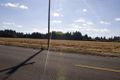
The location is about 80 feet... that way!

An unknown person unintentionally completed their first geohash!
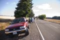
Believe it or not, there are four cars here... not that you can see them...
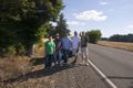
Strike a pose!


