Difference between revisions of "2015-11-21 52 1"
imported>Sourcerer m (→Achievements) |
m |
||
| (5 intermediate revisions by 2 users not shown) | |||
| Line 3: | Line 3: | ||
| lon=1 | | lon=1 | ||
| date=2015-11-21 | | date=2015-11-21 | ||
| + | | graticule_name=Norwich, UK | ||
| + | | graticule_link=Norwich, United Kingdom | ||
}} | }} | ||
__NOTOC__ | __NOTOC__ | ||
| Line 16: | Line 18: | ||
== Plans == | == Plans == | ||
| − | + | I opted to attempt this earlier as more bad weather is predicted overnight. | |
| − | |||
| − | |||
| + | == Expedition - Fail == | ||
| + | My closest approach (160 metres) was at 16:25. After parking at the recreation ground, there was a 10 minute walk to a gate leading into a meadow with grazing sheep. Mostly I avoid disturbing livestock. In addition, it was cold (4 C), very windy and wet; all demoralising factors so I gave up that route. There was some woodland along one field margin. Sometimes there's a dog walker's path which would have been ideal but not today. This was wet woodland with a stream running through and probably very soggy ground close by. | ||
== Photos == | == Photos == | ||
<gallery> | <gallery> | ||
| + | Image:2015-11-21 52 1 Sourcerer.jpg | Google Earth Track | ||
</gallery> | </gallery> | ||
| Line 36: | Line 39: | ||
}} | }} | ||
| − | |||
| − | |||
[[Category:Expeditions]] | [[Category:Expeditions]] | ||
[[Category:Expeditions with photos]] | [[Category:Expeditions with photos]] | ||
| − | [[Category:Coordinates reached]] | + | [[Category:Coordinates not reached]] |
| − | - | + | [[Category:Not reached - Mother Nature]] |
| + | {{location|GB|ENG|SFK}} | ||
Latest revision as of 09:24, 28 March 2022
| Sat 21 Nov 2015 in Norwich, UK: 52.3473599, 1.6691979 geohashing.info google osm bing/os kml crox |
Location
In a meadow north of Reydon Smear, Suffolk, UK.
Participants
Plans
I opted to attempt this earlier as more bad weather is predicted overnight.
Expedition - Fail
My closest approach (160 metres) was at 16:25. After parking at the recreation ground, there was a 10 minute walk to a gate leading into a meadow with grazing sheep. Mostly I avoid disturbing livestock. In addition, it was cold (4 C), very windy and wet; all demoralising factors so I gave up that route. There was some woodland along one field margin. Sometimes there's a dog walker's path which would have been ideal but not today. This was wet woodland with a stream running through and probably very soggy ground close by.
Photos
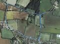
Google Earth Track

Achievements
Expeditions and Plans
| 2015-11-21 | ||
|---|---|---|
| Renfrew, Ontario | Someone went | Testing -- Jlam (talk) @45.6090,-76.4855 23:27, 21 November 2015 (EST) *T... |
| Kassel, Germany | GeorgDerReisende | The hash lay on a meadow north of Staufenberg-Nienhagen. |
| Norwich, United Kingdom | Sourcerer | In a meadow north of Reydon Smear, Suffolk, UK. |
Sourcerer's Expedition Links
2015-11-20 52 1 - 2015-11-21 52 1 - 2015-11-22 52 1 - KML file download of Sourcerer's expeditions for use with Google Earth.