Difference between revisions of "2015-08-31 52 1"
From Geohashing
imported>Sourcerer m (→Expedition) |
m |
||
| (2 intermediate revisions by 2 users not shown) | |||
| Line 3: | Line 3: | ||
| lon=1 | | lon=1 | ||
| date=2015-08-31 | | date=2015-08-31 | ||
| + | | graticule_name=Norwich, UK | ||
| + | | graticule_link=Norwich, United Kingdom | ||
}} | }} | ||
__NOTOC__ | __NOTOC__ | ||
| Line 46: | Line 48: | ||
[[Category:Expeditions with photos]] | [[Category:Expeditions with photos]] | ||
[[Category:Coordinates not reached]] | [[Category:Coordinates not reached]] | ||
| + | [[Category:Not reached - No public access]] | ||
| + | {{location|GB|ENG|NFK}} | ||
Latest revision as of 09:29, 28 March 2022
| Mon 31 Aug 2015 in Norwich, UK: 52.5314237, 1.6239763 geohashing.info google osm bing/os kml crox |
Location
In a field close to the river Waveney at Saint Olaves, Norfolk, UK.
Participants
Plans
Expedition two of two spanning midnight - 2015-08-30 52 1 - 2015-08-31 52 1 - ETA 00:00.
This might not be reachable. The river side properties are a bit "up-market" with fences, security lights and dogs. There might be access via a disused railway or from one of the boatyards.
Expedition - Fail
- Fail. Private grounds. -- Sourcerer (talk) @52.5345,1.6243 00:12, 31 August 2015 (GMT+01:00)
As expected there was no access without doing a blatant trespass. It might have been possible by boat.
Photos
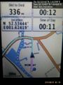
Proof of fail. @52.5345,1.6243
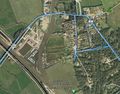
Track in Google Earth


Achievements
Expeditions and Plans
| 2015-08-31 | ||
|---|---|---|
| Christchurch, New Zealand | Quaternary | Christchurch Botanical Gardens, Hagley Park, Christchurch, New Zealand |
| Norwich, United Kingdom | Sourcerer | In a field close to the river Waveney at Saint Olaves, Norfolk, UK. |
Sourcerer's Expedition Links
2015-08-30 52 1 - 2015-08-31 52 1 - 2015-09-01 52 1 - KML file download of Sourcerer's expeditions for use with Google Earth.