2015-09-01 52 1
| Tue 1 Sep 2015 in Norwich, UK: 52.5097360, 1.5743122 geohashing.info google osm bing/os kml crox |
Location
In a field north east of Maypole Green, Norfolk, UK at sunflower.survive.model
Participants
Plans
Often I pair points spanning midnight but today it made more sense to do this one in daylight.
Expedition
- Arrived. -- Sourcerer (talk) @52.5097,1.5743 15:56, 1 September 2015 (GMT+01:00)
There was a very good footpath close to Saint Mary's church in Haddiscoe. After two or three hundred metres (a dog walk) the path deteriorated and there was little evidence for it later. It was easier to walk in the crop stubble than on the choked path. I had to fight my way through tall nettles to get out at the other end and the Bridle Way sign post was missing. There also appeared to be a deliberate attempt to block the path but I was not stopped. This path did not go close to the hashpoint so I returned by another route (anticlockwise on the track log). This started well but also faded into nothing. Missing paths have one advantage. Once you are lost and trackless, you can attempt to navigate as best you can by whatever route seems best. Today my missing path led right to the hashpoint. What a coincidence! It was in a field of stubble.
Photos
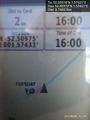
Proof. @52.5097,1.5743
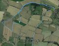
Track Log in Google Earth
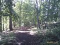
Nice beech woods near Haddiscoe.


Achievements
Sourcerer earned the OpenStreetMap achievement
|
Expeditions and Plans
| 2015-09-01 | ||
|---|---|---|
| Seattle, Washington | boomzilla | Strip mall is south Everett. |
| Norwich, United Kingdom | Sourcerer | In a field north east of Maypole Green, Norfolk, UK at sunflower.survive.model... |
Sourcerer's Expedition Links
2015-08-31 52 1 - 2015-09-01 52 1 - 2015-09-02 52 1 - KML file download of Sourcerer's expeditions for use with Google Earth.