2015-09-02 52 1
From Geohashing
| Wed 2 Sep 2015 in Norwich, UK: 52.2429722, 1.4587756 geohashing.info google osm bing/os kml crox |
Location
likes.sandbags.cubes - West of the A12 near Kelsale, a bit north of Saxmundham, Suffolk, UK. This is 440 metres from 2015-04-17 52 1.
Participants
Plans
Expedition one of two spanning midnight - 2015-09-02 52 1 - 2015-09-03 52 1 - ETA 22:35.
Expedition
- Arrived. -- Sourcerer (talk) @52.2430,1.4588 22:21, 2 September 2015 (GMT+01:00)
There was torrential rain and I'd forgotten my umbrella and water proofs. Luckily this eased off to a slight drizzle with lightning flashes in the distance. There was a parking place in the field entrance. The hashpoint was about 220 metres across harvested oil seed rape stubble. I only got slightly damp.
Photos
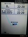
Proof. @52.2430,1.4588
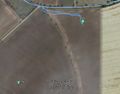
Track in Google Earth


Achievements
Expeditions and Plans
| 2015-09-02 | ||
|---|---|---|
| Portland, Oregon | Jim | A Hillsboro townhouse near the Orenco Station MAX station |
| Wien, Austria | Patrizius, B2c | In a field behind the the train tracks at business park Stadlau. |
| Mannheim, Germany | DODO | At the bank of lake Freyersee near Philippsburg (maybe with view to the nuc... |
| Kassel, Germany | GeorgDerReisende | The hash lay in the forest between Rengershausen and Guntershausen. |
| Norwich, United Kingdom | Sourcerer | likes.sandbags.cubes - West of the A12 near Kelsale, a bit north of Saxmund... |
| Amsterdam, Netherlands | Palmpje | On a path in a flower field in Noordwijkerhout, exactly PI kilometers from ... |
Sourcerer's Expedition Links
2015-09-01 52 1 - 2015-09-02 52 1 - 2015-09-03 52 1 - KML file download of Sourcerer's expeditions for use with Google Earth.