Difference between revisions of "2009-09-13 -37 145"
(planning) |
|||
| (21 intermediate revisions by 10 users not shown) | |||
| Line 7: | Line 7: | ||
| lon=145 | | lon=145 | ||
| date=2009-09-13 | | date=2009-09-13 | ||
| + | | graticule_name=Melbourne, East | ||
| + | | graticule_link=Melbourne East, Australia | ||
}} | }} | ||
<!-- edit as necessary --> | <!-- edit as necessary --> | ||
== Location == | == Location == | ||
| − | on a street in | + | on a street in Camberwell |
== Participants == | == Participants == | ||
| − | [[User:MykaDragonBlue|myka]] - and maybe a drag-along | + | [[User:MykaDragonBlue|myka]] - and maybe a drag-along :: no iea what time it will be though |
| + | |||
| + | [[User:Felix Dance|Felix Dance]] - Arrived just after 1pm, then just before 2pm, then about 6pm | ||
| + | |||
| + | Mitchell - About 1pm | ||
| + | |||
| + | [[User:tblundy|tblundy]] - Just before 2pm | ||
| + | |||
| + | [[User:Sashazeg|Sasha]] - About 3pm | ||
| + | |||
| + | [[User:Urcher|Urcher, Bilby and Doomhammer]] - Arrived at about 3:30 | ||
== Plans == | == Plans == | ||
| − | + | == Expeditions == | |
| − | == | + | |
| + | === Felix Dance === | ||
| + | |||
| + | This was a super-easy geohash for me - I was already going to ride from Port Melbourne out to Tempelstowe for a family do, and this geohash was pretty much right on the way. | ||
| + | |||
| + | I headed out at around 12:30 into the wind and pretty soon got to Camberwell. I got a call from Mitch just as I was arriving saying he was already there (by car), and I spent the next 20 minutes foolishly trying to navigate with my GPS and getting it wrong. | ||
| + | |||
| + | Taking some photos, I sped off to get to my family thing in Templestow, but who should I see right on Burke Road but my good friend Tim Blundy, who was returning from the same party I had just missed him at the previous night (coincidentally), so I went back and redid the hash with him, he not having done one before. | ||
| + | |||
| + | After the trip to Tempelstowe, I came back via the same route and took another couple of photos at the hash point - a three visit geohash, like my [[2009-05-25 -37 144]] expeditions. | ||
| + | |||
| + | [http://maps.google.com.au/maps?f=d&source=s_d&saddr=395+Bay+St,+Port+Melbourne+VIC+3207,+Australia+(Home,+Paint+and+Wallpaper)&daddr=-37.827595%C2%B0,+145.059713%C2%B0+to:-37.767865,145.103474+to:Mahoney+St,+Templestowe+VIC+3106+to:-37.827595%C2%B0,+145.059713%C2%B0+to:395+Bay+St,+Port+Melbourne+VIC+3207,+Australia&hl=en&geocode=%3BFfXLvv0dgW-lCA%3B%3B%3BFfXLvv0dgW-lCA%3B&mra=dpe&mrcr=1&mrsp=2&sz=13&via=2&dirflg=ht&sll=-37.776685,145.077553&sspn=0.102304,0.154324&ie=UTF8&ll=-37.795542,145.062962&spn=0.102278,0.154324&z=13 Here's] a map of my route. | ||
| + | |||
| + | === Urcher, Bilby and Doomhammer === | ||
| + | |||
| + | Drove to Tottenham station, trains to Camberwell, short walk to the hashpoint. | ||
| + | |||
| + | {{Youngest geohasher | ||
| + | | latitude = -37 | ||
| + | | longitude = 145 | ||
| + | | date = 2009-09-13 | ||
| + | | name = [[User:Urcher|Urcher]] | ||
| + | | name2 = Doomhammer | ||
| + | | years = 0 | ||
| + | | months = 0 | ||
| + | | days = 28 | ||
| + | | image = 2009 09 13 -37 144 doomhammer.jpg | ||
| + | |||
| + | }} | ||
| + | |||
| + | {{Meet-up | ||
| + | | latitude = -37 | ||
| + | | longitude = 145 | ||
| + | | date = 2009-09-13 | ||
| + | | name = [[User:Urcher|Urcher, Bilby and Doomhammer]] | ||
| + | | other = [[User:MykaDragonBlue|Myka]] | ||
| + | | image = 2009 09 13 -37 144 group.jpg | ||
| + | }} | ||
| + | {{Easy_geohash | ||
| − | == | + | | latitude = -37 |
| + | | longitude = 145 | ||
| + | | date = 2009-09-13 | ||
| + | | name = [[User:Felix Dance|Felix Dance]] | ||
| + | | image = Geohash 2009 09 13 -37 145 View to the North.jpg | ||
| + | }} | ||
== Photos == | == Photos == | ||
| − | |||
| − | |||
| − | |||
| − | |||
| − | |||
| − | |||
| − | |||
| + | === Felix Dance === | ||
| + | |||
| + | <gallery perrow="4"> | ||
| + | Image:Geohash 2009 09 13 -37 145 GPS.jpg|GPS - we made it! | ||
| + | Image:Geohash 2009 09 13 -37 145 View to the North.jpg|View north towards the station | ||
| + | Image:Geohash 2009 09 13 -37 145 View to the South.jpg|View south | ||
| + | Image:Geohash 2009 09 13 -37 145 Felix and Mitch.jpg|Felix and Mitch | ||
| + | Image:Geohash 2009 09 13 -37 145 Felix and Tim.jpg|Tim and Felix, second visit | ||
| + | Image:Geohash 2009 09 13 -37 145 View of the city from Bulleen.jpg|The city from Bulleen | ||
| + | Image:Geohash 2009 09 13 -37 145 Sunset from near the hash point.jpg|Sunset from near the hash | ||
| + | Image:Geohash 2009 09 13 -37 145 Felix at the hash point for the third time.jpg|Felix at his third hash visit | ||
</gallery> | </gallery> | ||
| + | === Urcher, Bilby and Doomhammer === | ||
| − | < | + | <gallery perrow="4"> |
| + | Image:2009 09 13 -37 144 tottenham.jpg | Urcher, Bilby and Doomhammer begin their journey at Tottenham train station | ||
| + | Image:2009 09 13 -37 144 train.jpg | Urcher, Bilby and Doomhammer journeying to the hashpoint by train. Doomhammer's first train ride | ||
| + | Image:2009 09 13 -37 144 doomhammer.jpg | Doomhammer at the hashpoint | ||
| + | Image:2009 09 13 -37 144 bilby.jpg | Bilby at the nearest intersection, for context | ||
| + | Image:2009 09 13 -37 144 group.jpg | Urcher, Bilby and Doomhammer meet up with Myka | ||
| + | Image:2009 09 13 -37 144 brunettis.jpg | Cafe around the corner for arvo tea, with Myka's mascot | ||
| + | Image:2009 09 13 -37 144 camberwell.jpg | Back to Camberwell station for the train home | ||
| + | </gallery> | ||
| − | |||
| + | === myka === | ||
| + | (choosing not to basically repeat any of the above photos) | ||
| + | <gallery perrow="4"> | ||
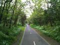
| + | Image:2009-09-13_-37_145_mdb_0005.jpg | The Outer Circle Rail Trail - looking forward | ||
| + | Image:2009-09-13_-37_145_mdb_0006.jpg | The Outer Circle Rail Trail - looking back | ||
| + | Image:2009-09-13_-37_145_mdb_0007.jpg | The Outer Circle Rail Trail - going under a road bridge. | ||
| + | Image:2009-09-13_-37_145_mdb_0012.jpg | [[User:MykaDragonBlue/Hashscot|possibly Fergus]] and my bike at the hash point. | ||
| + | Image:2009-09-13_-37_145_mdb_0022.jpg | The Outer Circle Rail Trail - one of the nicer sections on the way home. | ||
| + | </gallery> | ||
| − | |||
[[Category:Expeditions]] | [[Category:Expeditions]] | ||
| − | + | [[Category:Expeditions with photos]] | |
| − | [[Category:Expeditions with photos]] | ||
| − | |||
| − | |||
| − | |||
| − | |||
| − | |||
[[Category:Coordinates reached]] | [[Category:Coordinates reached]] | ||
| − | + | {{location|AU|VIC|BO}} | |
| − | |||
| − | |||
| − | |||
| − | |||
| − | |||
| − | |||
| − | |||
| − | |||
| − | |||
Latest revision as of 07:23, 29 March 2022
| Sun 13 Sep 2009 in Melbourne, East: -37.8275947, 145.0597134 geohashing.info google osm bing/os kml crox |
Contents
Location
on a street in Camberwell
Participants
myka - and maybe a drag-along :: no iea what time it will be though
Felix Dance - Arrived just after 1pm, then just before 2pm, then about 6pm
Mitchell - About 1pm
tblundy - Just before 2pm
Sasha - About 3pm
Urcher, Bilby and Doomhammer - Arrived at about 3:30
Plans
Expeditions
Felix Dance
This was a super-easy geohash for me - I was already going to ride from Port Melbourne out to Tempelstowe for a family do, and this geohash was pretty much right on the way.
I headed out at around 12:30 into the wind and pretty soon got to Camberwell. I got a call from Mitch just as I was arriving saying he was already there (by car), and I spent the next 20 minutes foolishly trying to navigate with my GPS and getting it wrong.
Taking some photos, I sped off to get to my family thing in Templestow, but who should I see right on Burke Road but my good friend Tim Blundy, who was returning from the same party I had just missed him at the previous night (coincidentally), so I went back and redid the hash with him, he not having done one before.
After the trip to Tempelstowe, I came back via the same route and took another couple of photos at the hash point - a three visit geohash, like my 2009-05-25 -37 144 expeditions.
Here's a map of my route.
Urcher, Bilby and Doomhammer
Drove to Tottenham station, trains to Camberwell, short walk to the hashpoint.
Urcher earned the Youngest Geohash Achievement
|
Urcher, Bilby and Doomhammer earned the Meet-up achievement
|
Felix Dance has visited an Easy Geohash
|
Photos
Felix Dance
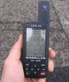
GPS - we made it!
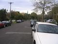
View north towards the station
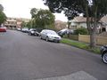
View south
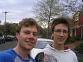
Felix and Mitch
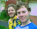
Tim and Felix, second visit
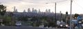
The city from Bulleen
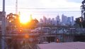
Sunset from near the hash

Felix at his third hash visit


Urcher, Bilby and Doomhammer
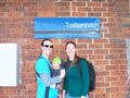
Urcher, Bilby and Doomhammer begin their journey at Tottenham train station

Urcher, Bilby and Doomhammer journeying to the hashpoint by train. Doomhammer's first train ride
Doomhammer at the hashpoint
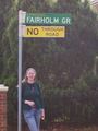
Bilby at the nearest intersection, for context
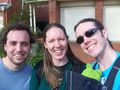
Urcher, Bilby and Doomhammer meet up with Myka

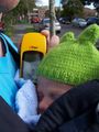
Cafe around the corner for arvo tea, with Myka's mascot
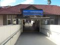
Back to Camberwell station for the train home


myka
(choosing not to basically repeat any of the above photos)
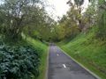
The Outer Circle Rail Trail - looking forward
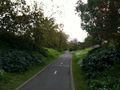
The Outer Circle Rail Trail - looking back
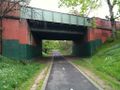
The Outer Circle Rail Trail - going under a road bridge.
possibly Fergus and my bike at the hash point.
The Outer Circle Rail Trail - one of the nicer sections on the way home.


