Difference between revisions of "2022-04-27 48 14"
m (→Achievements: fix link to track log) |
|||
| Line 68: | Line 68: | ||
| longitude = 14 | | longitude = 14 | ||
| date = 2022-04-27 | | date = 2022-04-27 | ||
| − | | tracklog = https://geohashing.site/geohashing/2022-04- | + | | tracklog = https://geohashing.site/geohashing/File:2022-04-27_48_14_pah_tracklog.gpx |
| possessive = his | | possessive = his | ||
| name = [[User:Pah|pah]] [[File:U+110DB.png|middle|6px|link=User:Pah]] | | name = [[User:Pah|pah]] [[File:U+110DB.png|middle|6px|link=User:Pah]] | ||
Revision as of 19:32, 28 April 2022
| Wed 27 Apr 2022 in 48,14: 48.2614654, 14.2865496 geohashing.info google osm bing/os kml crox |
Location
On a field in Linz-Bergern.
Participants
Plans
Take the first attempt towards a Tron achievement by bicycle after work unless it‘s raining too hard.
Expedition
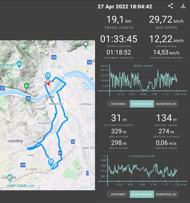
The hash was only some convenient 6.5 km away from pah‘s home ![]() , which is way to close not to go on an expedition after work, especially as it stopped raining throughout the day. Moreover, this looked like the perfect opportunity to strive for a Tron achievement — much nicer than the Drowned Rat Geohash that would have been achieved when going during lunch break. So pah prepared his
, which is way to close not to go on an expedition after work, especially as it stopped raining throughout the day. Moreover, this looked like the perfect opportunity to strive for a Tron achievement — much nicer than the Drowned Rat Geohash that would have been achieved when going during lunch break. So pah prepared his bicycle Light Cycle and started the tracklog without much upfront planning of the trip other than deliberately taking a very specific street towards the bridge over the Danube river. As a result, he had to do frequent stops on the way to do the planning as he progressed.
After around half the distance, pah had to cross railroad tracks and almost screwed his plans by crashing into his own walls when taking the circular ramp leading to the railroad underpass! phew, fortunately there was a small path straight ahead parallel to the track, so he decided to take his first detour. Google‘s navigation kept insisting that he should take a U turn and go back, but this was not an option due to his glowing walls behind him…
After about one kilometer, pah reached the next underpass to cross the railroad tracks and could continue in the direction of the hash. The remainder of the approach went well until the end of Google‘s navigation. He arrived in a park close to a „Hundefreilaufzone“ (dog park), where he then had to leave the paths. From there on, pah had to push his Light Cycle through some muddy trails in a forest, until he reached the open field with the hash. From there on, he tried to slowly and carefully approach the hash in order to avoid the need for a hash dance[1] . The second challenge were the small crops already growing on the field, which pah didn‘t want to trample. But GPS coordinates kept closing in and he managed to catch some proof reported well within GPS accuracy, therefore pah declares success nonetheless!
pah took some pictures of the surroundings (and forgot to capture his grin) and prepared for his trip home after a few minutes. He carefully took a wide circle back towards the muddy forest patch between the field and any paved roads. The tires of his Light Cycle had no grip at all and are not really designed for any kind of off-road usage. He still managed to return to a different street than he arrived on and started cycling home again. Soon he reached the a street which he already used before. Oh no, what now? Fortunately, there was a small trail on the side of a field next to the road which seems to go in the right general direction. He quickly checked the map, if there might be an exit on the other side and indeed, it seemed to lead towards paved territory after a short distance.
During this extra detour — again very muddy, but fortunately less steep — he passed by an archery field where some people were practicing. pah carefully tried to stay out of their shooting direction, because one never know how much practice they already had. One of the archers told him, where the shortest path to a paved street was and from there on, it was a smooth ride back home apart from continuously ignoring directions from Google maps to take the short, but already „walled“ path. A „Tron“ mode for Google maps would have been a nice feature here!
Right before reaching home again, pah took a final detour around the block to really make sure not to cross the starting point prematurely and finished this nice evening with indeed not crossing his own tracks. Success!
Tracklog
Photos
Achievements
pah
|
pah
|
- ↑ pah didn’t know until the writing of this report, that temporarily parking the light cycle in the vicinity of the hash and doing the regular hash dance wouldn’t void the Tron achievement… :-(


