Difference between revisions of "2022-05-27 -38 144"
([live picture]GPS proof) |
m (Location) |
||
| (7 intermediate revisions by one other user not shown) | |||
| Line 1: | Line 1: | ||
| − | + | {{meetup graticule | |
| − | |||
| − | |||
| − | |||
| − | |||
| − | |||
| − | |||
| − | |||
| − | |||
| lat=-38 | | lat=-38 | ||
| lon=144 | | lon=144 | ||
| date=2022-05-27 | | date=2022-05-27 | ||
| − | }} | + | }} |
__NOTOC__ | __NOTOC__ | ||
== Location == | == Location == | ||
| − | + | On the foreshore at Torquay | |
== Participants == | == Participants == | ||
| − | + | [[User:Johnwrw|John]] | |
| − | + | ||
| + | == Expedition == | ||
| + | The location for this one looked very appealing, on the grass in central Torquay just by the beach. I could get a Geelong train from Footscray to Marshall station and then ride from there, about 16km each way. | ||
| + | |||
| + | My laptop was being repaired at a shop in Footscray, and I was due to pick it up later that afternoon. Since I had to travel to Footscray anyway, and while I was without my computer I couldn't have done any work even if I wanted to, it was a very easy decision to make to add a journey to Torquay on top of my trip to Footscray. | ||
| + | |||
| + | I headed off from my new residence in Ascot Vale just before midday, and caught the 12:18 Geelong train from Footscray without any dramas. I was a bit unsure why the board didn't list any stations beyond Geelong, when google maps had told me it was running all the way through to Waurn Ponds, but I put it from my mind. | ||
| + | |||
| + | On the train I read a bit of Scott Ludlam's book, and after a while we were arriving at Geelong. An announcement came over the PA informing us that the train was indeed terminating at Geelong, and that the service through to Waurn Ponds was by way of a bus. Not very helpful for me with my bike. Now I had to ride in and out of downtown Geelong instead of from Marshall station, and the 16km each way to Torquay had now become more like 23km. | ||
| + | |||
| + | This was no big deal, but it meant that time was going to be a more pressing factor than I had hoped. There was a particular train I needed to get in order to be back in Footscray by 5 to pick up my laptop. But it was nice to see a bit of downtown Geelong. I rode south, passing Kardinia Park, and reached a stretch with significant roadworks which was very bicycle unfriendly, but I made it through and got onto a nicer road, Bailey St, to continue south. I crossed the train line just beyond my original intended alighting point of Marshall station, and continued south on Barwarre Rd. | ||
| + | |||
| + | This took me up to the Geelong Memorial Park and Crematorium, another cemetery after having visited Fawkner just [[2022-05-25 -37 144|a couple of days before]]. Turning left onto Burvilles Rd, I met and disturbed a flock of parrots. Fortunately, having been disturbed they went flying down the road in the direction that I was riding, so I kept up with them for several moments. This gave me a good opportunity to observe them, and judging from the amount of blue on their wings, I am confident in identifying them as blue-winged parrots. | ||
| + | |||
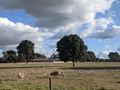
| + | Turning right, I joined Horseshoe Bend Rd, and followed this all the way into Torquay. It was a nice rural road to ride along, with little traffic, at least at that time of day and year. I passed horses and cows and sheep with little lambs, I went around the distinctive eponymous horseshoe bend in the road, and before I knew it I was approaching the hash. When I hit the coast, I followed the path into central Torquay, and then before me lay the reserve in which the hash was to be found. I traversed a little bit of grass and located the hash with minimal difficulty. After snapping a couple of pics, I locked up my bike and visited the cafe that can be seen above my left shoulder in the photo, and bought myself for lunch a delicious takeaway mushroom and goat's cheese and red pesto toastie. | ||
| + | |||
| + | With the time until my train left Geelong ticking down, I regrettably had little time to spend in Torquay, but while eating my toastie I was able to briefly pop down to the beach itself and greet the ocean. But then I had to move on. Sandwich consumed, I remounted my bike and began the return journey. I would have liked to have taken it at a slightly more relaxed pace, as I was beginning to get a little tired, but I had no choice but to press on. | ||
| − | + | I passed in a paddock an enormous flock of straw-necked ibises, which I could identify immediately having worked out what they were while on the [[2022-04-18 -37 145|Bundoora]] expedition the previous month. | |
| − | |||
| − | + | I drew closer to Geelong, my timing looking tight, but okay. The roadworky bit was just as yucky coming this way, but once again I survived. I eventually got to the station with a comfortable but not excessive 8 minutes to spare. The extra riding never really put me in danger of missing the train, it just meant that I had a fair bit less time available to enjoy Torquay/to allow me to stop anywhere that might have otherwise interested me. | |
| − | |||
| − | + | The most notable aspects of the train journey back was working out that Tarneit is an anagram of 'I natter', and falling asleep for a little nap immediately afterwards. I retrieved my computer from the shop, now excitingly with all the keys working on the keyboard. I stopped off briefly at the family home to do some animal feeding, before moving on and eventually getting back home to Ascot Vale just before 5.30. | |
| − | |||
== Photos == | == Photos == | ||
| − | + | ||
| − | |||
| − | |||
<gallery perrow="5"> | <gallery perrow="5"> | ||
| Line 38: | Line 41: | ||
Image:2022-05-27_-38_144_Johnwrw_1653635385033.jpg|GPS proof | Image:2022-05-27_-38_144_Johnwrw_1653635385033.jpg|GPS proof | ||
| + | |||
| + | Image:2022-05-27_-38_144_Johnwrw_1653747860098.jpg|Hash, different angle | ||
| + | |||
| + | Image:2022-05-27_-38_144_Johnwrw_1653747879265.jpg|Torquay beach | ||
| + | |||
| + | Image:2022-05-27_-38_144_Johnwrw_1653747908869.jpg|Sheep and lambs | ||
</gallery> | </gallery> | ||
== Achievements == | == Achievements == | ||
{{#vardefine:ribbonwidth|800px}} | {{#vardefine:ribbonwidth|800px}} | ||
| − | |||
| − | |||
| − | |||
| − | |||
| − | |||
| − | |||
| − | |||
| − | |||
| − | |||
| − | |||
| − | |||
[[Category:Expeditions]] | [[Category:Expeditions]] | ||
| − | + | ||
[[Category:Expeditions with photos]] | [[Category:Expeditions with photos]] | ||
| − | |||
| − | |||
| − | |||
| − | |||
| − | |||
| − | |||
| − | + | [[Category:Coordinates reached]] | |
| − | [[Category:Coordinates | + | {{location|AU|VIC|SC}} |
| − | |||
| − | |||
| − | |||
| − | |||
| − | |||
| − | |||
| − | |||
| − | |||
| − | |||
| − | |||
| − | |||
| − | |||
| − | |||
| − | |||
Latest revision as of 14:42, 28 May 2022
| Fri 27 May 2022 in -38,144: -38.3321144, 144.3267583 geohashing.info google osm bing/os kml crox |
Location
On the foreshore at Torquay
Participants
Expedition
The location for this one looked very appealing, on the grass in central Torquay just by the beach. I could get a Geelong train from Footscray to Marshall station and then ride from there, about 16km each way.
My laptop was being repaired at a shop in Footscray, and I was due to pick it up later that afternoon. Since I had to travel to Footscray anyway, and while I was without my computer I couldn't have done any work even if I wanted to, it was a very easy decision to make to add a journey to Torquay on top of my trip to Footscray.
I headed off from my new residence in Ascot Vale just before midday, and caught the 12:18 Geelong train from Footscray without any dramas. I was a bit unsure why the board didn't list any stations beyond Geelong, when google maps had told me it was running all the way through to Waurn Ponds, but I put it from my mind.
On the train I read a bit of Scott Ludlam's book, and after a while we were arriving at Geelong. An announcement came over the PA informing us that the train was indeed terminating at Geelong, and that the service through to Waurn Ponds was by way of a bus. Not very helpful for me with my bike. Now I had to ride in and out of downtown Geelong instead of from Marshall station, and the 16km each way to Torquay had now become more like 23km.
This was no big deal, but it meant that time was going to be a more pressing factor than I had hoped. There was a particular train I needed to get in order to be back in Footscray by 5 to pick up my laptop. But it was nice to see a bit of downtown Geelong. I rode south, passing Kardinia Park, and reached a stretch with significant roadworks which was very bicycle unfriendly, but I made it through and got onto a nicer road, Bailey St, to continue south. I crossed the train line just beyond my original intended alighting point of Marshall station, and continued south on Barwarre Rd.
This took me up to the Geelong Memorial Park and Crematorium, another cemetery after having visited Fawkner just a couple of days before. Turning left onto Burvilles Rd, I met and disturbed a flock of parrots. Fortunately, having been disturbed they went flying down the road in the direction that I was riding, so I kept up with them for several moments. This gave me a good opportunity to observe them, and judging from the amount of blue on their wings, I am confident in identifying them as blue-winged parrots.
Turning right, I joined Horseshoe Bend Rd, and followed this all the way into Torquay. It was a nice rural road to ride along, with little traffic, at least at that time of day and year. I passed horses and cows and sheep with little lambs, I went around the distinctive eponymous horseshoe bend in the road, and before I knew it I was approaching the hash. When I hit the coast, I followed the path into central Torquay, and then before me lay the reserve in which the hash was to be found. I traversed a little bit of grass and located the hash with minimal difficulty. After snapping a couple of pics, I locked up my bike and visited the cafe that can be seen above my left shoulder in the photo, and bought myself for lunch a delicious takeaway mushroom and goat's cheese and red pesto toastie.
With the time until my train left Geelong ticking down, I regrettably had little time to spend in Torquay, but while eating my toastie I was able to briefly pop down to the beach itself and greet the ocean. But then I had to move on. Sandwich consumed, I remounted my bike and began the return journey. I would have liked to have taken it at a slightly more relaxed pace, as I was beginning to get a little tired, but I had no choice but to press on.
I passed in a paddock an enormous flock of straw-necked ibises, which I could identify immediately having worked out what they were while on the Bundoora expedition the previous month.
I drew closer to Geelong, my timing looking tight, but okay. The roadworky bit was just as yucky coming this way, but once again I survived. I eventually got to the station with a comfortable but not excessive 8 minutes to spare. The extra riding never really put me in danger of missing the train, it just meant that I had a fair bit less time available to enjoy Torquay/to allow me to stop anywhere that might have otherwise interested me.
The most notable aspects of the train journey back was working out that Tarneit is an anagram of 'I natter', and falling asleep for a little nap immediately afterwards. I retrieved my computer from the shop, now excitingly with all the keys working on the keyboard. I stopped off briefly at the family home to do some animal feeding, before moving on and eventually getting back home to Ascot Vale just before 5.30.
Photos
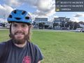
The cafe over my shoulder did me a decent toastie for lunch @-38.3321,144.3268
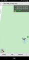
GPS proof
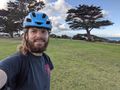
Hash, different angle
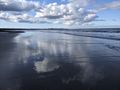
Torquay beach
Sheep and lambs


