Difference between revisions of "2022-08-30 51 10"
(expedition report for Clausthal-Zellerfeld) |
m (Location) |
||
| Line 46: | Line 46: | ||
[[Category:Coordinates reached]] | [[Category:Coordinates reached]] | ||
| + | {{location|DE|NI|GS}} | ||
Latest revision as of 07:42, 31 August 2022
| Tue 30 Aug 2022 in 51,10: 51.8078228, 10.3625086 geohashing.info google osm bing/os kml crox |
Location
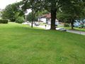
The hash lay between the houses Tannenhöhe 23 and 27 in Clausthal-Zellerfeld-Clausthal.
Participants
Plans
The plan was to travel by train and by bus to the bus stop Clausthal Jugendherberge and a short walk to the hash, then a long walk through the city.
Expedition
I arrived with the bus in Clausthal Kronenplatz and while the bus approached the bus stop I saw the connection bus to the place of the former youth hostel. I stepped out of the first bus, turned around, and the other bus was gone. This meant a four kilometer walk to the hash, the distance by air was 1.9 kilometer. The time for this need I missed later on my walk in the city. Because the hash lay between the houses, I did not dance around to find the exact coordinates.
Tracklog
Photos
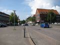
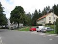
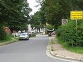
at the other bus stop, in the background, some seconds before, was my connection bus
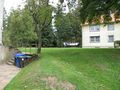
there, somewhere on the grass, was the hash
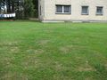
three meters ahead

proof
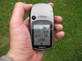
proof
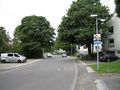
looking from the hash to the street
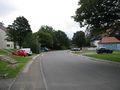
the street Tannenhöhe to the left
the street Tannenhöhe to the right

the geohasher
looking from the street to the hash
been in Clausthal-Zellerfeld


