Difference between revisions of "2022-08-03 58 5"
From Geohashing
(→Participants) |
(→Achievements) |
||
| (23 intermediate revisions by 3 users not shown) | |||
| Line 15: | Line 15: | ||
== Location == | == Location == | ||
<!-- where you've surveyed the hash to be --> | <!-- where you've surveyed the hash to be --> | ||
| − | Bore | + | Bore, Klepp, Norway |
== Participants == | == Participants == | ||
| Line 27: | Line 27: | ||
== Expedition == | == Expedition == | ||
<!-- how it all turned out. your narrative goes here. --> | <!-- how it all turned out. your narrative goes here. --> | ||
| + | It was a nice day for a trip, about 20° C and the wind was 6 m/s from the SW. The car park was about 1.2 km from the hash and there was no problem finding the right place. On the way from the hash back to the car, I walked a little closer to the sea so I got a nice view of Bore beach. There weren't many people out for a walk. | ||
== Tracklog == | == Tracklog == | ||
<!-- if your GPS device keeps a log, you may use Template:Tracklog, post a link here, or both --> | <!-- if your GPS device keeps a log, you may use Template:Tracklog, post a link here, or both --> | ||
| + | |||
| + | {{tracklog |Activity 9329235771.gpx}} | ||
== Photos == | == Photos == | ||
| Line 36: | Line 39: | ||
--> | --> | ||
<gallery perrow="5"> | <gallery perrow="5"> | ||
| − | + | Image:Screenshot 20220803-134248 Geohash Droid.jpg|Bore [https://openstreetmap.org/?mlat=58.79078200&mlon=5.55028180&zoom=16 @58.7908,5.5503] | |
| − | Image: | + | Image:20220803 58 5 1.jpg|On the way to the hash. |
| + | Image:20220803 58 5 2.jpg|View from the hash to the north. | ||
| + | Image:20220803 58 5 3.jpg|View from the hash to the east. | ||
| + | Image:20220803 58 5 4.jpg|View from the hash to the south. | ||
| + | Image:20220803 58 5 5.jpg|Bore beach. | ||
</gallery> | </gallery> | ||
| Line 44: | Line 51: | ||
<!-- Add any achievement ribbons you earned below, or remove this section --> | <!-- Add any achievement ribbons you earned below, or remove this section --> | ||
| − | + | {{land geohash |name=[[User:Pica42|Pica42]] |date=2022-08-03 |latitude=58 |longitude=5 }} | |
| − | |||
| − | [[ | ||
| − | |||
| − | |||
| − | |||
| − | |||
| − | |||
| − | |||
| − | |||
| − | |||
| − | |||
| − | |||
[[Category:Expeditions]] | [[Category:Expeditions]] | ||
| − | |||
[[Category:Expeditions with photos]] | [[Category:Expeditions with photos]] | ||
| − | |||
| − | |||
| − | |||
| − | |||
| − | |||
[[Category:Coordinates reached]] | [[Category:Coordinates reached]] | ||
| − | + | {{location|NO|11}} | |
| − | |||
| − | |||
| − | |||
| − | |||
| − | |||
| − | |||
| − | |||
| − | |||
| − | |||
| − | |||
| − | |||
| − | |||
| − | |||
| − | |||
| − | |||
| − | |||
| − | |||
Latest revision as of 12:34, 25 November 2022
| Wed 3 Aug 2022 in 58,5: 58.7907703, 5.5502631 geohashing.info google osm bing/os kml crox |
Location
Bore, Klepp, Norway
Participants
Plans
Expedition
It was a nice day for a trip, about 20° C and the wind was 6 m/s from the SW. The car park was about 1.2 km from the hash and there was no problem finding the right place. On the way from the hash back to the car, I walked a little closer to the sea so I got a nice view of Bore beach. There weren't many people out for a walk.
Tracklog
Photos

Bore @58.7908,5.5503
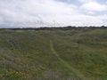
On the way to the hash.
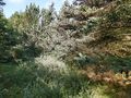
View from the hash to the north.
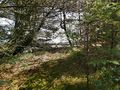
View from the hash to the east.
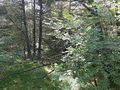
View from the hash to the south.
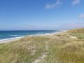
Bore beach.


Achievements
Pica42 earned the Land geohash achievement
|