Difference between revisions of "2022-12-17 58 5"
From Geohashing
(→Achievements) |
|||
| (3 intermediate revisions by the same user not shown) | |||
| Line 29: | Line 29: | ||
== Expedition == | == Expedition == | ||
<!-- how it all turned out. your narrative goes here. --> | <!-- how it all turned out. your narrative goes here. --> | ||
| + | |||
| + | Today's hash was only about 4 km from where I live, and I decided to go for a morning walk. Arriving at the hash, I found that there were many horses walking around and that a man with a tractor was spreading gravel on the ice on the road. I therefore decided to make another attempt after dark. Then there were no horses or people out so everything went well. | ||
== Tracklog == | == Tracklog == | ||
| Line 50: | Line 52: | ||
<!-- Add any achievement ribbons you earned below, or remove this section --> | <!-- Add any achievement ribbons you earned below, or remove this section --> | ||
| − | + | {{land geohash |name=[[User:Pica42|Pica42]] |date=2022-12-17 |latitude=58 |longitude=5 }} | |
| − | |||
| − | |||
| − | [[ | ||
| − | |||
| − | |||
| − | |||
| − | |||
| − | |||
| − | |||
| − | |||
| − | |||
| − | |||
| − | |||
| − | |||
[[Category:Expeditions]] | [[Category:Expeditions]] | ||
| − | |||
[[Category:Expeditions with photos]] | [[Category:Expeditions with photos]] | ||
| − | |||
| − | |||
| − | |||
| − | |||
| − | |||
[[Category:Coordinates reached]] | [[Category:Coordinates reached]] | ||
| + | {{location|NO|11}} | ||
| − | + | __NOTOC__ | |
| − | |||
| − | |||
| − | |||
| − | |||
| − | |||
| − | |||
| − | |||
| − | |||
| − | |||
| − | |||
| − | |||
| − | |||
| − | |||
| − | |||
| − | |||
| − | |||
Latest revision as of 19:20, 17 December 2022
| Sat 17 Dec 2022 in 58,5: 58.7987024, 5.6709891 geohashing.info google osm bing/os kml crox |

Location
In a paddock for horses on Øksnevad, Klepp, Norway
Participants
Plans
Expedition
Today's hash was only about 4 km from where I live, and I decided to go for a morning walk. Arriving at the hash, I found that there were many horses walking around and that a man with a tractor was spreading gravel on the ice on the road. I therefore decided to make another attempt after dark. Then there were no horses or people out so everything went well.
Tracklog
Photos

Øksnevad @58.7988,5.6710
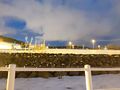
View to the north.
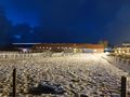
View to the west.
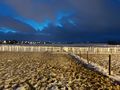
View to the south.
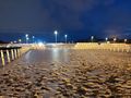
View to the east.


Achievements
Pica42 earned the Land geohash achievement
|