Difference between revisions of "2022-12-26 58 5"
From Geohashing
([live picture]Eike [https://openstreetmap.org/?mlat=58.73412240&mlon=5.82438340&zoom=16 @58.7341,5.8244]) |
(→Achievements) |
||
| (8 intermediate revisions by the same user not shown) | |||
| Line 14: | Line 14: | ||
== Location == | == Location == | ||
<!-- where you've surveyed the hash to be --> | <!-- where you've surveyed the hash to be --> | ||
| + | At the edge of a cultivated field/cow pasture at Eikeland, Time, Norway | ||
== Participants == | == Participants == | ||
<!-- who attended: If you link to your wiki user name in this section, your expedition will be picked up by the various statistics generated for geohashing. You may use three tildes ~ as a shortcut to automatically insert the user signature of the account you are editing with. | <!-- who attended: If you link to your wiki user name in this section, your expedition will be picked up by the various statistics generated for geohashing. You may use three tildes ~ as a shortcut to automatically insert the user signature of the account you are editing with. | ||
--> | --> | ||
| + | *[[User:Pica42|Pica42]] | ||
== Plans == | == Plans == | ||
| Line 24: | Line 26: | ||
== Expedition == | == Expedition == | ||
<!-- how it all turned out. your narrative goes here. --> | <!-- how it all turned out. your narrative goes here. --> | ||
| + | |||
| + | This was a hash trip early in the morning and before sunrise. I left home before 08:00 and was at the hash at 08:45. It was only a short walk from the parking lot to the hash. | ||
== Tracklog == | == Tracklog == | ||
<!-- if your GPS device keeps a log, you may use Template:Tracklog, post a link here, or both --> | <!-- if your GPS device keeps a log, you may use Template:Tracklog, post a link here, or both --> | ||
| + | |||
| + | {{tracklog |Activity 10187136789xx.gpx}} | ||
== Photos == | == Photos == | ||
| Line 35: | Line 41: | ||
Image:2022-12-26_58_5_Pica42_1672044559554.jpg|Eikeland [https://openstreetmap.org/?mlat=58.73414480&mlon=5.82434960&zoom=16 @58.7341,5.8243] | Image:2022-12-26_58_5_Pica42_1672044559554.jpg|Eikeland [https://openstreetmap.org/?mlat=58.73414480&mlon=5.82434960&zoom=16 @58.7341,5.8243] | ||
| − | |||
Image:2022-12-26_58_5_Pica42_1672044559560.jpg|Eikeland [https://openstreetmap.org/?mlat=58.73412150&mlon=5.82434900&zoom=16 @58.7341,5.8243] | Image:2022-12-26_58_5_Pica42_1672044559560.jpg|Eikeland [https://openstreetmap.org/?mlat=58.73412150&mlon=5.82434900&zoom=16 @58.7341,5.8243] | ||
| − | + | Image:20221226 084742.jpg|thumb|Photo taken in the direction of the hash. | |
| − | Image: | ||
</gallery> | </gallery> | ||
| Line 45: | Line 49: | ||
<!-- Add any achievement ribbons you earned below, or remove this section --> | <!-- Add any achievement ribbons you earned below, or remove this section --> | ||
| − | + | {{land geohash |name=[[User:Pica42|Pica42]] |date=2022-12-26 |latitude=58 |longitude=5 }} | |
| − | |||
| − | |||
| − | [[ | ||
| − | |||
| − | |||
| − | |||
| − | |||
| − | |||
| − | |||
| − | |||
| − | |||
| − | |||
| − | |||
| − | |||
[[Category:Expeditions]] | [[Category:Expeditions]] | ||
| − | |||
[[Category:Expeditions with photos]] | [[Category:Expeditions with photos]] | ||
| − | |||
| − | |||
| − | |||
| − | |||
| − | |||
[[Category:Coordinates reached]] | [[Category:Coordinates reached]] | ||
| + | {{location|NO|11}} | ||
| − | + | __NOTOC__ | |
| − | |||
| − | |||
| − | |||
| − | |||
| − | |||
| − | |||
| − | |||
| − | |||
| − | |||
| − | |||
| − | |||
| − | |||
| − | |||
| − | |||
| − | |||
Latest revision as of 10:24, 26 December 2022
| Mon 26 Dec 2022 in 58,5: 58.7341209, 5.8243329 geohashing.info google osm bing/os kml crox |
Location
At the edge of a cultivated field/cow pasture at Eikeland, Time, Norway
Participants
Plans
Expedition
This was a hash trip early in the morning and before sunrise. I left home before 08:00 and was at the hash at 08:45. It was only a short walk from the parking lot to the hash.
Tracklog
Photos
Eikeland @58.7341,5.8243

Eikeland @58.7341,5.8243
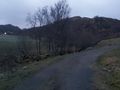
Photo taken in the direction of the hash.


Achievements
Pica42 earned the Land geohash achievement
|