Difference between revisions of "2022-12-22 58 5"
From Geohashing
(→Photos) |
(→Achievements) |
||
| (9 intermediate revisions by the same user not shown) | |||
| Line 26: | Line 26: | ||
== Expedition == | == Expedition == | ||
<!-- how it all turned out. your narrative goes here. --> | <!-- how it all turned out. your narrative goes here. --> | ||
| + | Today's hash trip was a car trip of about 42 km each way. In addition, it was a walk of just over a kilometer. | ||
| + | On my way to the hash, I passed a farmer who was out feeding his sheeps. I stopped and talked to him about sheeps, tractors, windmills, politics and other things. It was a very nice farmer. | ||
| + | Arriving at the hash point I found that it was very wet but I found the right point. | ||
== Tracklog == | == Tracklog == | ||
<!-- if your GPS device keeps a log, you may use Template:Tracklog, post a link here, or both --> | <!-- if your GPS device keeps a log, you may use Template:Tracklog, post a link here, or both --> | ||
| + | |||
| + | {{tracklog |Activity 10171174932.gpx}} | ||
== Photos == | == Photos == | ||
| Line 36: | Line 41: | ||
<gallery perrow="5"> | <gallery perrow="5"> | ||
Image:Screenshot 20221222-151646 Geohash Droid.jpg|thumb|Geohash | Image:Screenshot 20221222-151646 Geohash Droid.jpg|thumb|Geohash | ||
| − | Image:20221222 .jpg|thumb| | + | Image:20221222 .jpg|thumb|A farmer and his sheeps. |
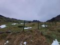
| − | Image:20221222 58 5 NW.jpg|thumb | + | Image:20221222 58 5 NW.jpg|thumb|View to the northwest. |
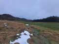
Image:20221222 58 5 W.jpg|thumb|View to the west. | Image:20221222 58 5 W.jpg|thumb|View to the west. | ||
Image:20221222 58 5 E.jpg|thumb|View to the east. | Image:20221222 58 5 E.jpg|thumb|View to the east. | ||
Image:20221222 58 5 NE.jpg|thumb|View to the northeast. | Image:20221222 58 5 NE.jpg|thumb|View to the northeast. | ||
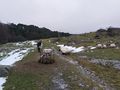
Image:20221222 151617.jpg|thumb|It was wet at the hash point. | Image:20221222 151617.jpg|thumb|It was wet at the hash point. | ||
| + | Image:20221222 58 5 Retur home.jpg|thumb|Swans. | ||
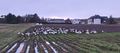
| + | Image:2022-12-22_58_5_Pica42_1672044559545.jpg|Matningsdsl | ||
</gallery> | </gallery> | ||
| Line 49: | Line 56: | ||
<!-- Add any achievement ribbons you earned below, or remove this section --> | <!-- Add any achievement ribbons you earned below, or remove this section --> | ||
| − | + | {{land geohash |name=[[User:Pica42|Pica42]] |date=2022-12-22 |latitude=58 |longitude=5 }} | |
| − | |||
| − | |||
| − | [[ | ||
| − | |||
| − | |||
| − | |||
| − | |||
| − | |||
| − | |||
| − | |||
| − | |||
| − | |||
| − | |||
| − | |||
[[Category:Expeditions]] | [[Category:Expeditions]] | ||
| − | |||
[[Category:Expeditions with photos]] | [[Category:Expeditions with photos]] | ||
| − | |||
| − | |||
| − | |||
| − | |||
| − | |||
[[Category:Coordinates reached]] | [[Category:Coordinates reached]] | ||
| + | {{location|NO|11}} | ||
| + | {{Last man standing | ||
| + | | latitude = 58 | ||
| + | | longitude = 5 | ||
| + | | date = 2022-12-22 | ||
| + | | gender = man | ||
| + | | name = [[User:Pica42|Pica42]] | ||
| + | }} | ||
| − | + | __NOTOC__ | |
| − | |||
| − | |||
| − | |||
| − | |||
| − | |||
| − | |||
| − | |||
| − | |||
| − | |||
| − | |||
| − | |||
| − | |||
| − | |||
| − | |||
| − | |||
Latest revision as of 10:49, 26 December 2022
| Thu 22 Dec 2022 in 58,5: 58.5913156, 5.8356739 geohashing.info google osm bing/os kml crox |
Location
On a farm in Matningsdal, Hå, Norway
Participants
Plans
Expedition
Today's hash trip was a car trip of about 42 km each way. In addition, it was a walk of just over a kilometer. On my way to the hash, I passed a farmer who was out feeding his sheeps. I stopped and talked to him about sheeps, tractors, windmills, politics and other things. It was a very nice farmer. Arriving at the hash point I found that it was very wet but I found the right point.
Tracklog
Photos

Geohash
A farmer and his sheeps.
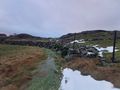
View to the northwest.
View to the west.
View to the east.
View to the northeast.
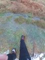
It was wet at the hash point.
Swans.

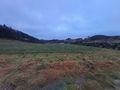
Matningsdsl


Achievements
Pica42 earned the Land geohash achievement
|
Pica42 earned the Last man standing achievement
|