Difference between revisions of "2022-09-28 50 9"
From Geohashing
(expedition report for Langenselbold) |
(+ regional geohashing achievement) |
||
| (One intermediate revision by one other user not shown) | |||
| Line 36: | Line 36: | ||
File:2022-09-28 50 9 GeorgDerReisende 6360.jpg | the geohasher | File:2022-09-28 50 9 GeorgDerReisende 6360.jpg | the geohasher | ||
</gallery> | </gallery> | ||
| + | |||
| + | == Achievements == | ||
| + | {{#vardefine:ribbonwidth|100%}} | ||
| + | <!-- Add any achievement ribbons you earned below, or remove this section --> | ||
| + | |||
| + | {{Regional geohashing | name = GeorgDerReisende | region = Main-Kinzig-Kreis | count = 2 }} | ||
[[Category:Expeditions]] | [[Category:Expeditions]] | ||
| Line 42: | Line 48: | ||
[[Category:Coordinates reached]] | [[Category:Coordinates reached]] | ||
| + | {{location|DE|HE|MKK}} | ||
Latest revision as of 00:17, 14 January 2023
| Wed 28 Sep 2022 in 50,9: 50.1886483, 9.0429393 geohashing.info google osm bing/os kml crox |
Location
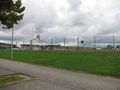
On the car parking of the sports area of Langenselbold at the Niedergründauer Straße.
Participants
Plans
I came from 2022-09-28 51 10, traveled to Langenselbold and wanted to walk straight to the hash.
Expedition
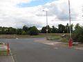
I took the bus to the Lindenplatz and when the bus stop was announced, I pushed the stopbutton, but the bus didn't stop there and I had a short stop at Hüttengesäß. After taking the bus to the Lindenplatz I walked to the sports area and made it to the hash. Afterwards I walked around the village, and I traveled home.
Photos
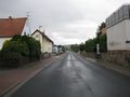
a street with two bus stops in Hüttengesäß
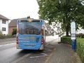
arrived at the Lindenplatz
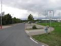
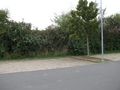
the hash area
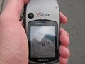
proof 1
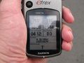
proof 2
looking north
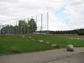
east
south
west

the geohasher


Achievements
GeorgDerReisende earned the Regional geohashing achievement
|