Difference between revisions of "2023-02-19 58 5"
From Geohashing
(→Location) |
|||
| (8 intermediate revisions by the same user not shown) | |||
| Line 19: | Line 19: | ||
<!-- who attended: If you link to your wiki user name in this section, your expedition will be picked up by the various statistics generated for geohashing. You may use three tildes ~ as a shortcut to automatically insert the user signature of the account you are editing with. | <!-- who attended: If you link to your wiki user name in this section, your expedition will be picked up by the various statistics generated for geohashing. You may use three tildes ~ as a shortcut to automatically insert the user signature of the account you are editing with. | ||
--> | --> | ||
| + | *[[User:Pica42|Pica42]] | ||
== Plans == | == Plans == | ||
| Line 25: | Line 26: | ||
== Expedition == | == Expedition == | ||
<!-- how it all turned out. your narrative goes here. --> | <!-- how it all turned out. your narrative goes here. --> | ||
| + | |||
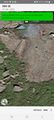
| + | On the trip to find today's hash, I was unsure where it was allowed to park, so I asked my wife to drive me to a place quite close to the hash. Then I went on a dirt road and on a path in the terrain to the hash. I found the zero point in a steep cliff that was too steep to climb without climbing gear. I therefore went as close as I could without taking a great risk of falling. The zero point is marked with a red X on one image | ||
== Tracklog == | == Tracklog == | ||
| Line 35: | Line 38: | ||
<gallery perrow="5"> | <gallery perrow="5"> | ||
| − | Image:2023-02-19_58_5_Pica42_1676797067276.jpg| | + | Image:2023-02-19_58_5_Pica42_1676797067276.jpg|Vatnamot |
| + | Image:Screenshot 20230219-095144 Geohash Droid.jpg|thumb|Vatnamot | ||
| + | Image:20230219 100634.jpg|thumb|On the way to the hash. | ||
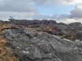
| + | Image:20230219 S.jpg|thumb|View to the south. | ||
| + | Image:20230219 E2.jpg|thumb|View to the east. | ||
| + | Image:20230219 X.jpg|thumb|The red cross shows the hash point. | ||
</gallery> | </gallery> | ||
| Line 42: | Line 50: | ||
<!-- Add any achievement ribbons you earned below, or remove this section --> | <!-- Add any achievement ribbons you earned below, or remove this section --> | ||
| − | |||
| − | |||
| − | |||
| − | |||
| − | |||
| − | |||
| − | |||
| − | |||
| − | |||
| − | |||
| − | |||
| − | |||
| − | |||
| − | + | {{land geohash |name=[[User:Pica42|Pica42]] |date=2023-02-19 |latitude=58 |longitude=5 }} | |
[[Category:Expeditions]] | [[Category:Expeditions]] | ||
| − | |||
[[Category:Expeditions with photos]] | [[Category:Expeditions with photos]] | ||
| − | |||
| − | |||
| − | |||
| − | |||
| − | |||
[[Category:Coordinates reached]] | [[Category:Coordinates reached]] | ||
| − | + | {{location|NO|11}} | |
| − | |||
| − | |||
| − | |||
| − | |||
| − | |||
| − | |||
| − | |||
| − | |||
| − | |||
| − | |||
| − | |||
| − | |||
| − | |||
| − | |||
| − | |||
| − | |||
| − | |||
Latest revision as of 11:39, 19 February 2023
| Sun 19 Feb 2023 in 58,5: 58.4963914, 5.8446142 geohashing.info google osm bing/os kml crox |
Location
A little way into the heath at Vatnamot, Hå, Norway
Participants
Plans
Expedition
On the trip to find today's hash, I was unsure where it was allowed to park, so I asked my wife to drive me to a place quite close to the hash. Then I went on a dirt road and on a path in the terrain to the hash. I found the zero point in a steep cliff that was too steep to climb without climbing gear. I therefore went as close as I could without taking a great risk of falling. The zero point is marked with a red X on one image
Tracklog
Photos
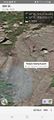
Vatnamot
Vatnamot
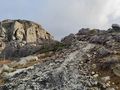
On the way to the hash.
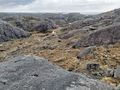
View to the south.
View to the east.
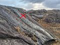
The red cross shows the hash point.


Achievements
Pica42 earned the Land geohash achievement
|