Difference between revisions of "2023-02-23 58 5"
(→Photos) |
(→Achievements) |
||
| (7 intermediate revisions by the same user not shown) | |||
| Line 12: | Line 12: | ||
| date=2023-02-23 | | date=2023-02-23 | ||
}}<!-- edit as necessary --> | }}<!-- edit as necessary --> | ||
| − | [[Image: | + | [[Image:20230223_58_5.jpg|thumb|left]] |
== Location == | == Location == | ||
<!-- where you've surveyed the hash to be --> | <!-- where you've surveyed the hash to be --> | ||
| Line 27: | Line 27: | ||
== Expedition == | == Expedition == | ||
<!-- how it all turned out. your narrative goes here. --> | <!-- how it all turned out. your narrative goes here. --> | ||
| + | |||
| + | Today's trip to a hash was the most strenuous hash trip I've had. I had planned the trip quite carefully, but at the start of the trail there was a closed gate with a notice that the trail was closed and was no longer accessible to hikers. I therefore drove about 15 km to another place to park there. The path that went from this place was not good, see the pictures. | ||
| + | The trip from the start of the trail to the hash and back to where I had parked the car took almost 3 hours. The trip was cold and in some places there was ice on the path. It was still a great trip, the view from the mountain was beautiful. | ||
== Tracklog == | == Tracklog == | ||
<!-- if your GPS device keeps a log, you may use Template:Tracklog, post a link here, or both --> | <!-- if your GPS device keeps a log, you may use Template:Tracklog, post a link here, or both --> | ||
| + | |||
| + | {{tracklog |activity_10568290157.gpx}} | ||
== Photos == | == Photos == | ||
| Line 38: | Line 43: | ||
Image:2023-02-23_58_5_Pica42_1677149887832.jpg|Øykjafjellet [https://openstreetmap.org/?mlat=58.86035410&mlon=5.88710800&zoom=16 @58.8604,5.8871] | Image:2023-02-23_58_5_Pica42_1677149887832.jpg|Øykjafjellet [https://openstreetmap.org/?mlat=58.86035410&mlon=5.88710800&zoom=16 @58.8604,5.8871] | ||
| − | + | Image:20230223 58-5- This is the path immediately after the start of the trip.jpg|thumb|This is the path immediately after the start of the trip. | |
| − | + | Image:20230223 58 5-Part of the path.jpg|thumb|Part of the path. | |
| − | + | Image:20230223 The path went on the rock shelf to the left of the picture..jpg|thumb|The path went on the rock shelf to the left of the picture. | |
| + | Image:20230223 58 5-W.jpg|thumb|View to the west from the hash. | ||
| + | Image:20230223 S.jpg|thumb|View to the south from the hash. | ||
| + | Image:20230223 Part of the path.jpg|thumb|Part of the path. | ||
</gallery> | </gallery> | ||
| Line 47: | Line 55: | ||
<!-- Add any achievement ribbons you earned below, or remove this section --> | <!-- Add any achievement ribbons you earned below, or remove this section --> | ||
| − | + | {{land geohash |name=[[User:Pica42|Pica42]] |date=2023-02-23 |latitude=58 |longitude=5 }} | |
| − | |||
| − | |||
| − | [[ | ||
| − | |||
| − | |||
| − | |||
| − | |||
| − | |||
| − | |||
| − | |||
| − | |||
| − | |||
| − | |||
| − | |||
[[Category:Expeditions]] | [[Category:Expeditions]] | ||
| − | |||
[[Category:Expeditions with photos]] | [[Category:Expeditions with photos]] | ||
| − | |||
| − | |||
| − | |||
| − | |||
| − | |||
[[Category:Coordinates reached]] | [[Category:Coordinates reached]] | ||
| + | {{location|NO|11}} | ||
| − | |||
| − | |||
| − | |||
| − | |||
| − | |||
| − | |||
| − | |||
| − | |||
| − | + | __NOTOC__ | |
| − | |||
| − | |||
| − | |||
| − | |||
| − | |||
| − | |||
Latest revision as of 12:52, 24 February 2023
| Thu 23 Feb 2023 in 58,5: 58.8603301, 5.8871427 geohashing.info google osm bing/os kml crox |

Location
Øykjafjellet, Noredalen, Sandnes, Norway
Participants
Plans
Expedition
Today's trip to a hash was the most strenuous hash trip I've had. I had planned the trip quite carefully, but at the start of the trail there was a closed gate with a notice that the trail was closed and was no longer accessible to hikers. I therefore drove about 15 km to another place to park there. The path that went from this place was not good, see the pictures. The trip from the start of the trail to the hash and back to where I had parked the car took almost 3 hours. The trip was cold and in some places there was ice on the path. It was still a great trip, the view from the mountain was beautiful.
Tracklog
Photos

Øykjafjellet @58.8604,5.8871
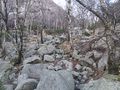
This is the path immediately after the start of the trip.
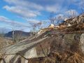
Part of the path.
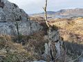
The path went on the rock shelf to the left of the picture.
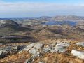
View to the west from the hash.
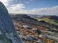
View to the south from the hash.
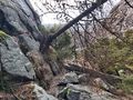
Part of the path.


Achievements
Pica42 earned the Land geohash achievement
|